Going to California
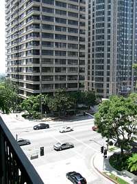
![Wilshire]() Wilshire from our balcony
Wilshire from our balcony
Ah…Cali; the Babylonical object that is paradise personified in the minds of many a man and woman…especially those not from or already in California.
We had a little more than a week in the state. Wednesday June 17th Brian, Dan and I left work to board a redeye flight out of Logan Airport in Boston, arriving around midnight, Pacific Time, at LAX. We stayed at Brian’s brother’s place in Westwood, on Wilshire Blvd, and hung around there and Santa Monica, seeing the beaches in the day and the bars at night. Friday all of us braved the weekend traffic to drive down to San Diego. We arrived late afternoon at our Marriot, right next door to Petco Park. We had a weekend there, and the plan was to hit up a Padres game, the beaches, and the bars at PB and Gaslamp. We accomplished all of the above with the exception of the beaches, as the weather Saturday did not cooperate. Instead, we drove around the city deliberating on what to do. The famed San Diego Zoo was a short drive away, and we had already parked and walked up to the entrance gate before deciding to turn back, the two main reasons for doing so being that a) we did not want to pay 40 bucks each to go to a zoo, and b) having to pay 40 bucks, we didn’t really want to spend the next three or four hours in a zoo just so we could get our money’s worth. Brian, however, took a picture in front of the zoo as proof that he’d been there.
![San Diego Zoo!]() Misleading picture at the SD Zoo
Misleading picture at the SD Zoo
We discussed for awhile whether or not to stay in SD for Sunday, the prospect of another night out at the bars and the Hard Rock Café Pool Party beckoning to us, but we ultimately decided to head back to LA, as some parties in our group were much hungover from the night before, and though we stopped to check out Laguna Beach on the journey back, we also stopped at a few parking lots in San Clemente for puke breaks. That night we were all too exhausted to do anything except check out, appropriately enough, The Hangover, at a nearby theatre. It was very hilarious.
Planning to Summit
We discussed for awhile whether or not to stay in SD for Sunday, the prospect of another night out at the bars and the Hard Rock Café Pool Party beckoning to us, but we ultimately decided to head back to LA, as some parties in our group were much hungover from the night before, and though we stopped to check out Laguna Beach on the journey back, we also stopped at a few parking lots in San Clemente for puke breaks. That night we were all too exhausted to do anything except check out, appropriately enough, The Hangover, at a nearby theatre. It was very funny and fitting.
![Rockies and Angels conversing]() Angels chilling with Rockies
Angels chilling with Rockies![Angels Stadium]() At Angels Stadium
At Angels Stadium
We had wanted to watch a ballgame at each one of the Southern Cal ballparks. However, due to scheduling issues and poor foresight, we did not have a chance to watch the Dodgers, which was a shame since they have a pretty classic venue. Monday was our chance to head down to Anaheim after a day at the beaches. They were playing the Rockies, and were getting shelled by the time we left around the 4th or 5th inning.
We decided to get a few more beers in the area before heading back to Westwood. It wasn’t our fault that Hooters was the first place we saw.
In looking through Google Maps to find a nearby car rental agency, I found and noted that the Playboy Mansion was only a few minutes away from Sean’s place. After driving through Anaheim, bottoming out on a few curbs, and having quite a thrilling dance party in the car, I did my best to remember what the street layout looked like and we took a detour to check out the place before getting back pretty late to Sean’s place.
I was exhausted, we all were, having run up a pretty significant sleep deficit from the last few nights. The plan was to hit up Mt. San Antonio the next morning. To avoid traffic, I thought that we best get going by 6 AM, maybe even 5. Dan and Brian were not looking forward to this part. They, not being avid peakbaggers, had only agreed to accompany me on the mountain because I had whipped Brian for 3 consecutive weeks in Beirut prior to Cali, and for a few of the games I set Baldy as part of the stakes.
Even though they were obligated through honour and respect for the great sport of Beruit, I still tried to impress upon that Baldy, being 9-12 miles round trip with 4000 ft of elevation gain, was not an easy walk in the part. This did not sink in until late Monday night, around 2 AM. After some discussion, it was agreed that instead of going hiking they would check out Santa Barbara, while I borrowed Sean’s car to climb Baldy. I really didn’t care about Beruit honour at that point; all I wanted to do was get to sleep and get some semblance of an early start for tomorrow.
I got up around 6 or 7 AM, later than originally intended, and set off soon afterwards. The traffic wasn’t as bad as I feared, since you were generally headed away from LA. I felt my first twinges of excitement as I pulled onto I-210; looking north into the San Gabriels, I saw the sun, for the first time today, peeking through the smog and burning it off. I got to Upland in about an hour, where I stocked up on some protein bars. Then it was up the surprisingly steep Mt. Baldy Road (but I suppose it shouldn’t have been a surprise, since you gain about 5000 ft in 10 or so miles).
![Greater LA from trailhead]() LA from Trailhead
LA from Trailhead
Beaches and bars are nice, but as an Easterner who craves the magnificence of the American West, it was so tantalizing to be in California and still stuck in the city all the time. My excitement perked even when we drove by some hills in Laguna or Malibu and I was drooling at the dirt ridges. The drive to the Baldy trailhead was, henceforth, an amazingly refreshing douse of fresh air; more refreshing, even, than the prospect of a watermelon slushee after a day at the beach (I say prospect because California beach vendors do not sell slushees. This appears to be rather exclusive to New England). The clear morning air, the open desert fields, the classic canyons, the expansive views to the mountains above and around, and to the metropolis of suburbia below, made my heart shiver for the first time this trip, knowing that I was truly now back in the West. Looking back down at the smog cover below, rending greater LA invisible to the eye, I did not regret forsaking another day of beaches and beers in Santa Barbara.
![San Antonio Falls]() San Antonio Falls San Antonio Falls |
![Trail Split]() The Trail Split The Trail Split |
The road, for some reason, reminded me at parts to the road headed up to the Snowy Range, near Laramie, Wyoming. I soon found the parking lot, packed up my backpack, laced up my boots, and walked up the dirt road to the left which led to the San Antonio Falls. The dirt road switchbacks and takes a hard right at the falls, and I only got a somewhat distant view of them. I made breakneck pace on the road, and afterwards, after I found the trail turn-off on the left towards Baldy. My plan that day was to ascend the Baldy Bowl Route, and, if I made good time, descend via the Devil’s Backbone. Soon after the trail turnoff the views opened up towards the namesake Bowl. I spied the hut in the distance. It seemed fairly close, but I knew that it was still a few miles away, and probably about 2000 ft above where I was. The trail was great, following along one side of a canyon as the two sides merged into Mt. San Antone. The morning air was crisp, and I especially loved the sparse evergreen forest, somewhat similar to what I had grown up with 800 miles away in Flagstaff, AZ.
![Walking into Baldy Bowl]() into the Baldy Bowl into the Baldy Bowl |
![Along the Baldy Bowl trail]() Along the Baldy Bowl Trail Along the Baldy Bowl Trail |
![Cool Ridges on Baldy South Ridge]() South Ridge of Baldy South Ridge of Baldy |
![San Gabriels along Baldy Bowl Trail]() San Gabriel Mountains San Gabriel Mountains |
I had hiked a few summits before, climbed local summits in New England, done 14ers and other mountains out west, some difficult ones too, but on those occasions, being extremely out of shape each time (I probably could not jog 15 feet before running out of breath), I had to force my way step by step up the mountain. This was my first time taking on a peak out west since going to the gym and getting in shape, and I wanted to see how much I could push my body. I didn’t really get tired until probably a hundred feet below the ski hut, so I took a break there and took down one of my cliff bars.
I would come to have several miscommunications with the mountain on this day. The first one was Baldy itself. The summit is pretty obvious once you’re on the trail, and it stares at you the entire time, even as you drive up the road to the trailhead. However, I had convinced myself that this was a false summit, West Baldy, perhaps, and that the true summit was higher and hiding behind this false summit and the connecting saddle.
![The actual Baldy Bowl]() crossing the Baldy Bowl to gain the ridge crossing the Baldy Bowl to gain the ridge |
![Looking south from Ridge]() looking back down from ridge looking back down from ridge |
Another minor misunderstanding was the route itself. I had only skimmed the SP description of it and, now looking at the false, but what I thought to be true, summit, I assumed that the trail ascended to the top via the hut side of the canyon/bowl (east side). Soon after leaving the hut the trail crossed a boulderfield in the middle of the Baldy Bowl, to the other side of the canyon, and began to gain the crest of the ridge on the west. This caused me some apprehension for some time; I was not sure if I was on the right trail, but didn’t want to retrace my steps. In this case it was my assumptions that were incorrect, not my route, and I was soon reassured by signs higher up indicating that this was still the Baldy Bowl trail.
I have climbed to higher elevations before, including 14ers. As Baldy was barely above 10K, I did not worry too much about the elevation at all. What I failed to note was that, even though I had climbed 14ers my first day in Colorado, I had at least spent the previous night in one of the mountain towns probably between 7000-10000 ft in elevation. This morning I was at sea level. Though I was still pushing my pace, I found myself slowing and running out of breath more often after having gained the ridge.
![landscape on the Baldy Bowl Trail]() landscape higher up landscape higher up |
![Gorgonio and Jacinto]() Gorgonio and Jacinto rising above San Gabriels Gorgonio and Jacinto rising above San Gabriels |
Soon the trees began to really clear up, and I observed some nice meadows on the sides of the trail. I still thought I had a considerable way to go. I still thought that I had a false summit ahead of me, and then a descent, and then a re-ascent to the proper summit. Thus, the top of Baldy completely snuck up on me. I heard some voices from above but could not hear the people speaking them. I was surprised, thinking “why would people be gathering on a false summit?” As I topped out, a couple more details clued me into the fact that I was done climbing. The people, for one. If that didn’t do the trick, the cairns, rockwalls, the fact that there was no higher summit in near sight, and that giant metal sign on the ground did much to shake me out of my delusions. I summitted about two hours and forty minutes after leaving the car and was satisfied with this.
![homestretch on the Baldy Bowl Trail]() last few hundred ft to summit last few hundred ft to summit |
![trees clearing near summit]() Unbeknownst to myself I'm almost at the summit Unbeknownst to myself I'm almost at the summit |
Heaven on top: Summit and West Baldy
![Gorgonio and Jacinto]() San Gorgonio and San Jacinto San Gorgonio and San Jacinto |
![South towards the OC]() OC and Santa Ana Mtns OC and Santa Ana Mtns |
![San Gabriels and Mt. Baden Powell]() Baden Powell Baden Powell |
I was awestruck by the views. They were among the best I’d ever seen, even when compared to Colorado and other states. Despite their proximity to LA the San Gabriels have a lot of character. The views to Gorgonio and Jacinto were especially breathtaking, with low waves of clouds and/or smog fighting to entrench themselves in their lower foothills. On the other side of the range I saw I-15 snaking its way past the San Gabriels on its way to Vegas, into the giant expanse of the Mojave. Somewhere out there too, I knew, were the unseen, and personally, untread wonders of the Sierra Nevada. There was still a thin smog cover over the city, but it had burned off enough to allow visibility of some roads and houses. Having driving through and around LA and the OC the last few days, it was pretty amazing to note the same features from above, and then looking beyond them towards the Pacific. The Santa Ana Range, near Irvine, which had looked pretty big when you’re on the highway, now looked like toy mountains.
![West Baldy from Baldy]() West Baldy from Baldy West Baldy from Baldy |
![West Baldy from Saddle]() West Baldy from saddle West Baldy from saddle |
After a little bit of chatting, relaxing, and eating, I made my way down to the saddle and up to the top of West Baldy. I enjoyed this different perspective for awhile, then returned back to the saddle and the Baldy summit. After some more pictures and chatting I continued east, following the signs for the Devil’s Backbone route. I was reluctant to leave. I think I could have spent an entire day on top of that mountain.
![West towards the Pacific from West Baldy]() west from W Baldy west from W Baldy |
![Baldy from West Baldy]() Baldy from W Baldy Baldy from W Baldy |
![Gorgonio and Jacinto]() Gorgonio and Jacinto from W Baldy Gorgonio and Jacinto from W Baldy |
![Near W Baldy/Baldy Saddle]() Downed trees on subsummit Downed trees on subsummit |
![Summit Shot]() Summit shot Summit shot |
![Summit Shot]() Summit shot Summit shot |
Hell on the way down
![Mt. Harwood]() Traverse around Harwood Traverse around Harwood |
![Baldy from Devil s Backbone Trail]() Baldy on the descent Baldy on the descent |
The trail descended pretty steeply from the Baldy summit, traversing around the side of neighboring Mt. Harwood. The first part of this descent was one of the most enjoyable I’d ever experienced, since the entire time you are staring into the massive massifs of San Gorgonio and San Jacinto, their visages increasing slightly as you inch ever closer in their direction. The Backbone itself was pretty unique, the rocks and dirt in the area before it odd colored, and there were some pretty cool trees lining up either side of the trail. Then, as I got close to the ski area I descended a grassy ski run (Turkey Ridge or Turkey Run, I think).
![Windblown trees]() windblown trees on Harwood slope windblown trees on Harwood slope |
![Devil s Backbone]() Devil's Backbone Devil's Backbone |
Here is where things began to turn ugly for me. I had talked to some people on the summit about the Devil’s Backbone route. Among the things they told me was the advice that I should head towards the Ski Hut/Office once I got to the ski area. This I did…somewhat. I walked beside it. I think the proper route would have been to take the dirt road behind it, all the way back down to the trailhead. I say I think because I did not, still do not, know where that dirt road intersected the ski area. I continued straight, assuming it was in that direction. I walked past what appeared to be an empty parking lot. I continue to go straight, descending. After a few more minutes, I walked by a few ski lifts. Then, the dirt road I was on headed into slightly thicker tree cover. A sign told me I was leaving the ski area, and that this area was unpatrolled. I soon found myself in a canyon. I passed what appeared to be the remnants of some old mines or quarries. As the dirt road turned into a trail, then into nothing, I realized that I was off-route. Not wanting the hassle of having to retrace my steps, and reascend all that I had just descended, I continued down the canyon.
![Side Canyon]() in the wrong side canyon
in the wrong side canyon
I figured at this point that I had walked too far. The correct canyon was to my right (west). I figured that these two canyons would eventually join up, as all canyons usually do. The problem was, as I continued to walk down through the canyon, was that, not having a map, I did not know where these two canyons would meet up. I feared that it would be past the trailhead, and I didn’t want to have to hitchhike my way back up the Baldy Road. And there was also the outside shot that this side canyon was going to continue on until I walked myself back onto I-210. I did not like that possibility either.
![Climbing up side canyon slope]() climbing up canyon slope climbing up canyon slope |
![scree gully on Baldy]() descending scree descending scree |
Weighing all this I decided to leave the side canyon. Instead of retreating the way I came, back to the ski area, I decided to traverse up over the canyon slope on my right and directly back into the correct canyon. I climbed a few hundred feet of loose dirt before I crested over the slope and saw Manker Canyon, the correct canyon of the Devil’s Backbone Route. To my chagrin the road was on the opposite slope of the canyon. To meet it would require going all the way down and then reclimbing a lot of loose dirt. After downclimbing some more, I was able to ascertain the trailhead directly ahead of me, and decided to straight-shoot my way there.
It was starting to get pretty hot now, and I was starting to get pretty tired. I still had a decent amount of water in my backpack, but held my thirst as much as possible, just in case. As I continued to descend towards the trailhead I realized that the terrain was getting looser, rockier, and steeper. Between me and the car was a scree gully, which emptied out into a bigger scree/talus gully where the side canyon I had been in joined Manker Canyon. I tried to descend along the side of the scree. I went down some class 3/4 rock ledges, then cliffed out. By now, an impassably thick thicket of trees and shrub stood between me and the scree. I had no choice but to force my way through it. It wasn’t fun. Fortunately, my habit of wearing long sleeve pants on the mountain paid off here.
I found myself continuing down the scree. The stuff was extremely unstable. I was constantly slipping and sliding. There were some bigger rocks too. They soon found themselves sliding as well, a few hundred feet down, thanks to yours truly. I wondered if any of the forest rangers in the area heard the rockslides.
One slip at a time, I made my way down the scree and talus. I had picked up a walking stick, and I’m sure without it it would’ve been much worse. The road and the parking lot was within sight the entire time, but looked so small and far away. At some point on this descent I became aware that the back of my pants were now torn to shreads. I was angry. I really liked these pants.
The rocks at bigger the lower I got. The terrain improved too, after I had descended the steepest parts of the gully. I struggled the last few hundred feet through a few boulderfields and minor talus and breathed a huge sign of relief upon reaching the road.
There were a few people at the trailhead, none whom I had seen on the way up or on top of the mountain. I wondered what they thought of me as I walked nonchalantly through the brush to the car, boxers hanging out of the back of what used to be a very serviceable pair of pants.
I dusted off my backpack. I dusted off myself. I drank some water. I drove back to Westwood. Brian Dan and Sean were still on their way back from Santa Barbara. They had the keys to the apartment. With boxers still hanging out I got some gas, did some shopping at Target, and got some fast food. I was beyond caring at this point.
It had been a rough day on the mountain. We were all tired, so we just relaxed and had a low key night at one of the bars in the Westwood/Santa Monica area. As I drank I reflected over my routefinding skills, long known to myself to be atrocious. I had underestimated this mountain, being so close to LA and the suburbs. Perhaps I had not done my due diligence, researched the area and the routes more. Perhaps I was too stubborn about my refusal to ever retrace my steps (this trait would resurface to my detriment less than a month later). Whatever happened on the mountain though, I was still grateful for its good tidings. It had been such a great day before hell broke loose, and I would not have traded the latter at the price of the former.


 San Antonio Falls
 The Trail Split
 into the Baldy Bowl
 Along the Baldy Bowl Trail
 South Ridge of Baldy
 San Gabriel Mountains
 crossing the Baldy Bowl to gain the ridge
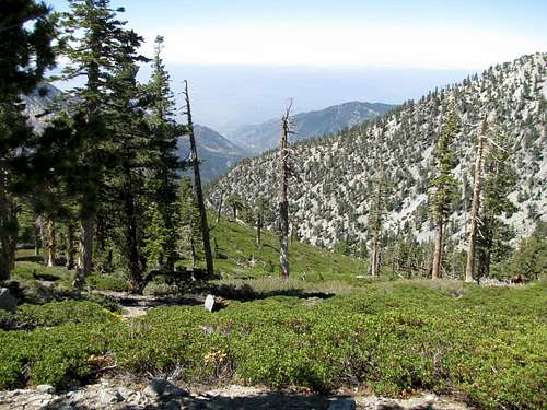 looking back down from ridge
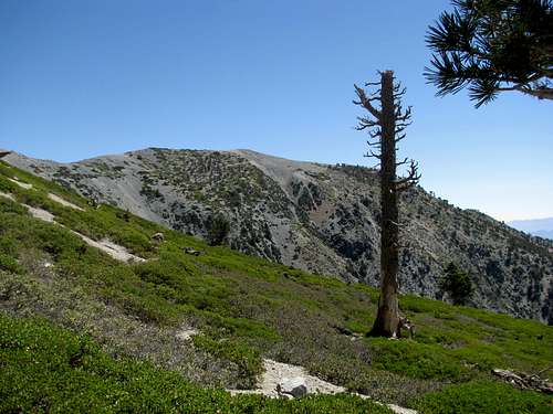 landscape higher up
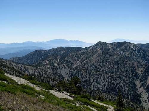 Gorgonio and Jacinto rising above San Gabriels
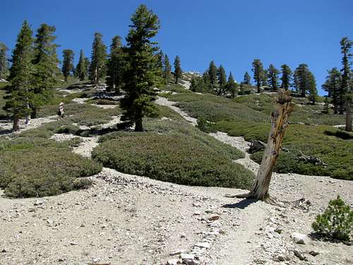 last few hundred ft to summit
 Unbeknownst to myself I'm almost at the summit
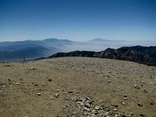 San Gorgonio and San Jacinto
 OC and Santa Ana Mtns
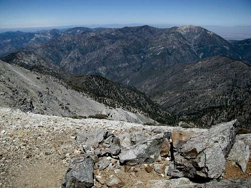 Baden Powell
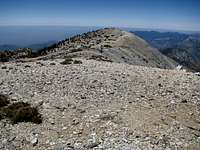 West Baldy from Baldy
 West Baldy from saddle
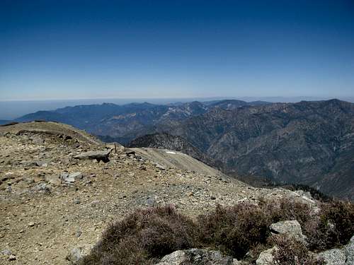 west from W Baldy
 Baldy from W Baldy
 Gorgonio and Jacinto from W Baldy
 Downed trees on subsummit
 Summit shot
 Summit shot
 Traverse around Harwood
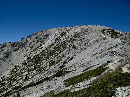 Baldy on the descent
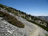 windblown trees on Harwood slope
 Devil's Backbone
 climbing up canyon slope
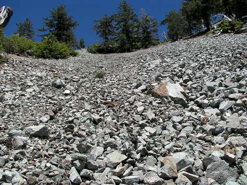 descending scree