

-
 40687 Hits
-
 81.17% Score
-
 14 Votes
|
|
Route |
|---|---|
|
|
40.77650°N / 110.3723°W |
|
|
Hike ~ Scramble |
|
|
One to two days |
|
|
Class 2 |
|
|
Approach
See getting there (Henry's Fork trailhead)
Route Description
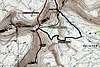
The trailhead elevation is approximately 9440’ with a summit elevation of 13,512. The total trail (contour slope) is 12.2± miles one-way, with 5252’ of elevation gain. The trail heads in a Southerly direction on a gradual rise. After about 2.9± miles and 430’ of elevation gain you will intersect with the Alligator lake trail that heads off to the right. Continue straight for another 2.4± miles and about 455’ of elevation gain you will come across a sign for the Elkhorn stream crossing to the left or the stream fording crossing straight. At this point turn left or East and cross via a log bridge. After crossing continue heading in a Southerly direction for another 2.4± miles and another 500’ of elevation gain. This should get you opposite Dollar Lake, this is a good spot to camp or continue on and setup camp closer to the peaks. Continue on the main trail for another 1.25 miles to a point where leaving the trail and heading south to Anderson Pass chute is feasible. Staying on the main trail will take you over Gunsight Pass, the typical route to King's Peak, Contour around the west side of Gunsight Pass Peak for another 1.5 miles to the base of the chute. If snow covered, crampon up and hit it up the throat, if rock, just pick your way up through the scree, watch for rocks slides. The chute gains about 1,000’ of elevation in 0.25 of a mile. After reaching Anderson Pass start the scramble to Kings Peak, after one mile and another 900 of elevation you will have arrived on top of the world (Utah's anyway).
The trip can be accomplish in a one long day outing, but is usually done in two to three days.
 |  |  |
Essential Gear
Summer - Typical summer camping gear, be aware that the Uintas can receive snow at almost any time of the year.
Winter - Skis, crampons and ice axe for the Anderson Pass chute.
Miscellaneous Info
If you have information about this route that doesn't pertain to any of the other sections, please add it here.
Littlebeef2 - Sep 18, 2010 1:07 pm - Hasn't voted
Contour after GunsightNoooooooooooooooooooooooo. I tried that. REALLY LARGE boulders that are NOT firmly situated. Very dangerous and very time consuming. My son descended into Painters and walked to the other side of the boulders and beat us by 30 minutes. I'm thankful my daughter was not hurt as we "contoured" around the west side of the hump. Don't do this. Take the HIGH trail from Gunsight (the "new Trail" over the top) or descend into Painters and then up to Anderson from Painters Basin. This is a fine option and very safe and pretty.
dan_3lliott - Oct 29, 2020 5:47 pm - Hasn't voted
Re: Contour after GunsightOdd that you found the contour sketchy - I've done it as well as the descent and ascent into painter's basin and I found the contour much easier and faster.
sunkissed4011 - Sep 25, 2014 12:37 pm - Hasn't voted
Trail Markers w/ mileageI brought my Garmin on the approach to Dollar Lake/Henry's Fork Lake. At ~3 miles I did not see a sign for Alligator Lake, just a great spot to take a break by a stream. At ~5.3 I came to a stream crossing and the log bridge, however the trail sign said Bear Lake, not Elkhorn. From here it's ~2.8 miles to Dollar Lake, although there is a sign that says no camp fires with 1000ft of Dollar Lake, the actual lake is at about 1 mile from here. Continue and you will see a sign for Henry's Fork Lake...break trail and find some fantastic camping to the S/SW or right off the trail to the east. At the top of Gunsight Pass there are 2 very distinct sets of carins; one straight(south) or right(west). I went right and was pleased with the number of carins and the directness of the trail. It is definitely a scramble to the summit once you pass Anderson Pass.