
-
 369131 Hits
-
 99.49% Score
-
 114 Votes
|
|
Mountain/Rock |
|---|---|
|
|
40.77639°N / 110.37293°W |
|
|
Hiking, Mountaineering, Skiing |
|
|
Spring, Summer, Fall, Winter |
|
|
13528 ft / 4123 m |
|
|
Under New Ownership
This page was transferred to me by Bob Bolton. I am very thankful to be able to adopt and continue to provide lots of information about this wonderful peak here on SummitPost. Some of the text below was written by Bob.
 Kings Peak and South Kings Peak
Overview
Kings Peak is the highpoint of Utah, and of Duchesne County. It is the seventh highest of the U.S. State Highpoints and located approximately 42 miles north of Duchesne in the High Uintas Wilderness Area of the Ashley and Wasatch National Forests. The mountain was named after Clarence King, who was the first director of the US Geological Survey. The standard hiking route is a 28.8 mile round trip trek, so the peak is usually climbed as part of a backpacking trip.
The present-day Kings Peak wasn't known to be the highest point in Utah before the mid 1960s. The USGS hadn't determined whether the current Kings Peak or South Kings Peak was the highest of the two summits prior to satellite measurements taken in 1966. Prior to this discovery, the USGS had marked South Kings Peak as the highest peak in Utah. Any hikers going to Utah's highest peak prior to 1966 would have scaled South Kings Peak instead of the now official Kings Peak.
Kings Peak's topographic prominence is 6,348 feet and ranks 19th in the contiguous 48 states. It is one of 57 so-called "Ultra" prominence peaks, those with more than 5,000 feet of prominence. For the complete list of Ultras, see this page.
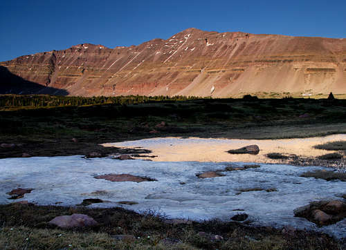
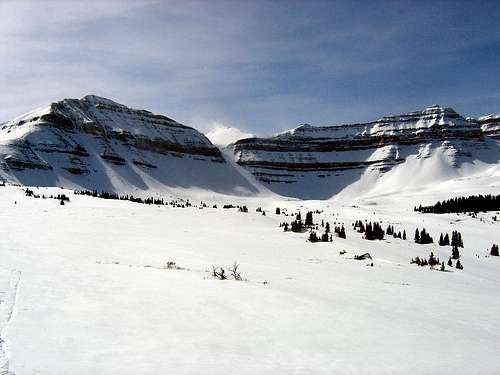
 Kings Peak Kings Peak |
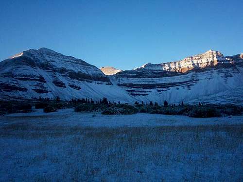
 Kings Peak at sunset Kings Peak at sunset |
 Kings Peak Kings Peak |
Trailheads
Henry's Fork Trailhead
This trailhead is on the north side of the range. Take exit 39 off Interstate 80 on Wyoming and turn south on State Route 414. Go 6 miles to Mountain View, WY where route 414 turns west through Mountain View and becomes Route 410 as the road turns south at the west end of town. Drive Route 410 for 6.7 miles toward Robertson, WY to the point where it turns west. From this point, drive Uinta County Road 283 (also named Forest Road 072) south toward Grahams Reservoir and Bridger Lake for 12.1 miles to Forest Road 017. Turn left on Forest Road 017 and continue south 6.8 miles to Forest Road 077. Drive south on Forest Road 077 for 2.8 miles, and turn right on the road to Henry's Fork Campground and the Henry's Fork Trailhead. This is the trailhead most people use for a climb of Kings Peak. The hike is beautiful but expect crowds in July and August.
Yellowstone Creek (Swift Creek) Trailhead
This trailhead is on the south side of the range and although not quite as scenic as the hike from Henry's Fork, it offers a very mellow hike up the long Yellowstone Creek Trail. If you're coming from the east in Roosevelt, Utah, continue south through town on US Highway 40 / 191. Don't head onto UT 121. Follow Highway 40 as it turns back to the southwest and after 5.6 miles, turn right on UT 87 (AKA Ioka Lane) and follow this paved highway for 16.5 miles to the town of Altamont. A quarter-mile west of this town, turn right (north) onto 16,000 West and continue another 4 miles. Turn left onto 8,000 North, then right again on 17,000 West which then curves left and turns into 9,000 North and then into Yellow Stone Road. Cross the Yellow Stone River and continue 5.5 miles on the now gravel road to the forest boundary where the road turns into FR 119. Continue down the hill and pass the Yellowstone Group Campground and Bridge Campground, crossing the river again back to its east side. 4 miles past the Bridge Campground, reach the Swift Creek Campground at the end of the road and park at the trailhead marked by a large sign.
Or, if you are coming from the west in Duchene, turn north onto State Highway 87. Follow State Highway 87 until it joins with State Highway 134 (this is where state Highway 87 heads due east instead of continuing north) between milepost 15 and 16. Follow State Highway 134 (21,000 West) north to the little town of Mountain Home. Where State Highway 134 begins to head due east at Mountain Home, Continue north on 21,000 West and turn right on 20,780 West at the T junction 0.7 miles north of town. Continue on 20,780 West for 4 miles, heading down the hill and turning right onto a short road which crosses the Lake Fork River. After crossing the bridge, turn left (north) on Yellowstone River Road and follow the road to the trailhead at the Swift Creek Campground as described above.
Uinta River Trailhead
This trailhead is also on the south side of the range and provides a longer, more scenic approach than the Yellowstone Creek route. From the intersection of Highway 121 and Highway 40 in the town of Roosevelt in the Uinta Basin, drive west on 200 North (Highway 121). Stay on Highway 121 as it quickly bends to the north. Most junctions are marked with signs, but they are very hard to read in the dark. At mile 9.9, just after the actual mile marker 10 at a stop sign, at the hamlet of Neola go straight towards Uintah Canyon. At mile 16.7 continue straight. At mile 18, turn right to Uintah Canyon. At mile 21.9 turn right. At mile 22.2 turn left just after the bridge. Park at the trailhead at mile 25.6.
Approaches
This approach avoids the crowds of the Henry's Fork approach. From the trailhead (see above) hike about a half mile up the Yellowstone Creek Trail to a junction where you have two choices. You can either continue straight up the Yellowstone Creek Trail for 17 uneventful miles to Anderson Pass. This avoids the ups and downs and makes for easy route-finding but the hike through the Yellowstone Creek valley is in the forest nearly the whole way. Only the last couple miles are in the nice alpine meadows above treeline. Yellowstone Creek does form a narrow, deep gorge that you'll pass by through the trees which may make the boring hike a little more interesting.
The other option is to turn right shortly after the trailhead and hike the Swift Creek trail to Milk Lake. This trail is much more scenic as it hikes on a ridge crest for a while and passes by a few large beaver ponds before reaching Deer Lake, which is at 10,200 feet and 6 miles from the trailhead. After Deer Lake, continue on the trail and after 0.75 miles, you will come to a junction. Turn left and follow the trail past Farmers Lake and over Bluebell Pass, and then descend to Milk Lake. From Milk Lake, follow the base of the ridge to the east all the way to Anderson Pass. The route passes through many spectacular and beautiful alpine meadows full of wildflowers. There is no trail after Milk Lake, but the cross-country route is easy to find since there are open views and travel is not difficult.
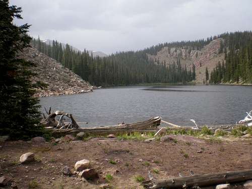 Deer Lake
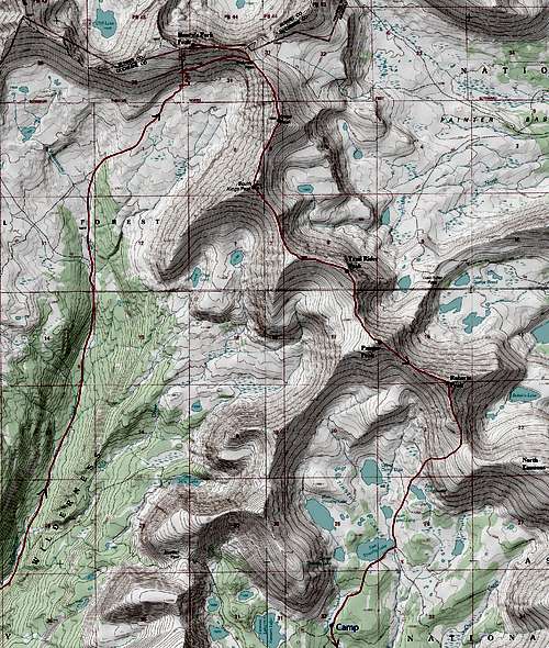
This is the most popular approach for Kings Peak coming from the north side of the range. The trail heads in a Southerly direction on a gradual rise. After about 3 miles and 430 feet of elevation gain, you will intersect with the Alligator Lake trail that heads off to the right. Continue straight for another 2.4 miles where you will come across a sign for the Elkhorn stream crossing to the left. At this point turn left (east) and cross via a log bridge. After crossing continue heading in a southerly direction for another couple miles where you reach Dollar Lake. This is a good spot to camp or you can continue on and setup camp closer to Gunsight Pass. Continue on the main trail to Gunsight Pass and hike the ridge over Gunsight Pass Peak and continue down to Anderson Pass where the North Ridge Route of Kings Peak takes off.
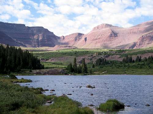 Henry's Fork Lake
This approach starts on the south side of the range but approaches Kings Peak from the east. This route is very long tough and rarely done. Allow 2-4 days for this 50 mile round-trip hike. From the trailhead at 7800 feet elevation, follow the trail north along the Uinta River. After about 3.6 miles, you will reach a junction where you turn left and cross Sheep Bridge and onto the Chain Lakes Trail. Follow this steep trail to the Chain Lakes Basin. Lower Chain Lake is about 9.2 miles from the trailhead and at 10,580 feet elevation. The 4th Chain Lake is 1.8 miles beyond at 10,900 feet elevation. Any of these lakes make a fine campsite. From the upper Chain Lake, take the trail over Roberts Pass to the Lake Atwood Basin, and then over Trail Rider Pass to Painter Basin. You could follow the trail all the way to Anderson Pass, but the shortest way is to climb the east face of Kings directly and moot the north ridge. There is a lot of boulder hopping but doesn't exceed Class 2.
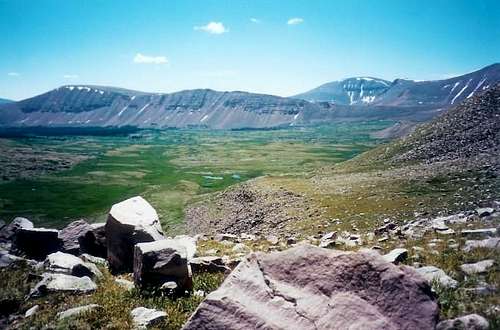 Painter Basin
North Ridge Standard Route - Class 1+
This is the standard route on Kings Peak and regardless on which approach you take (with the possible exception of the Uinta River Trail), the route begins at Anderson Pass. From the pass, hike south on the ridge to the summit. It's actually pretty simple and only takes about an hour from Anderson Pass and there is a worn boot path most of the way.
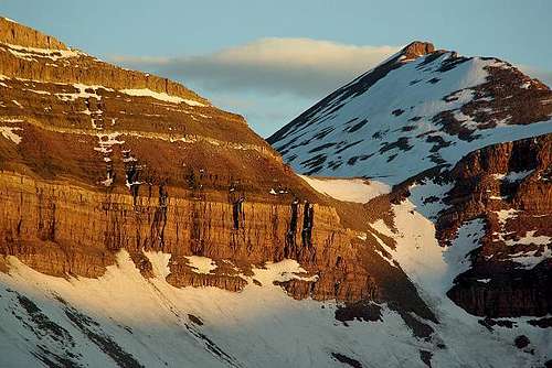
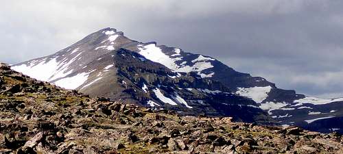 Kings Peak's North Ridge on the right skyline
Kings-Emmons Ridge Run
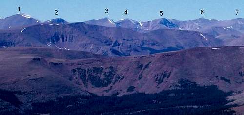
The Kings to Emmons ridge-run is arguably the highest sustained ridge-crest in the entire Rocky Mountain chain outside of Colorado. It provides a fantastic peak-bagging adventure and endurance test as you will pass over seven 13ers if you complete the ridge. For climbers wanting to try this long hike, the best place to start is the Yellowstone/Swift Creek trailhead and make a huge loop out of the ridge. When I did it, I hiked all the way up to Anderson Pass on the Yellowstone Creek Trail all night long, then headed south on the ridge getting the first five of the peaks before tiring out and bailing down into the upper Timothy Lakes basin and hiking out the Swift Creek Trail. You can get all 7 peaks before descending Swift Creek but make sure there is no chance for thunderstorms to develop as you will be way above treeline for many hours. Other nearby 13ers like "Henry's Fork Peak" and Gunsight Peak can also be tagged. The loop can also be done in the opposite direction. The peaks on the ridge from north to south are as follows:
| Name | Elevation (ft) | Prominence (ft) |
| Kings Peak | 13,528 | 6,358 |
| South Kings Peak | 13,512 | 372 |
| "Trail Rider Peak" | 13,247 | 362 |
| "Painter Peak" | 13,387 | 329 |
| "Roberts Peak" | 13,287 | 543 |
| "North Emmons" | 13,068 | 481 |
| Mount Emmons | 13,440 | 930 |
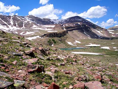
 Kings-Emmons Ridge...North (Mount Emmons) is to the left Kings-Emmons Ridge...North (Mount Emmons) is to the left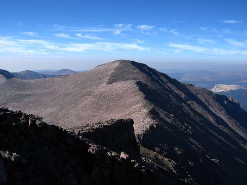 Looking south to South Kings Peak Looking south to South Kings Peak |
 Map showing the Kings-Emmons ridge-run loop (first 5 peaks). North Emmons and Emmons are just off to the east Map showing the Kings-Emmons ridge-run loop (first 5 peaks). North Emmons and Emmons are just off to the east |
Map
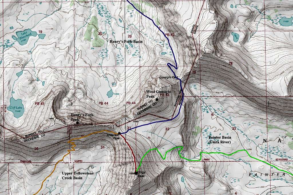
ORANGE: Yellowstone Creek Approach - Class 1
BLUE: Henry's Fork Approach via Gunsight Pass - Class 1
GREEN: Uinta River Approach and East Slopes Route - Class 2
RED: North Ridge Standard Route - Class 1+
When To Climb
Generally the best conditions for climbing Kings Peak occur from June through September, depending on snow and weather conditions. It is certainly climbable any time of year however mid-winter ascents will require skis, lots of warm clothing, a liberal dose of spare time and a love for sub-zero temperatures and hurricane force winds!
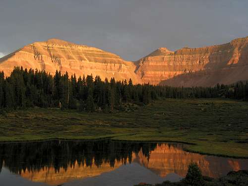
 Kings in Winter Kings in Winter |
 Kings in Summer Kings in Summer |
 Kings in Fall Kings in Fall |
Camping/Red Tape
Camping can be found at any of the trailheads without charge and there is no red tape. Camping is also available at any of the lakes on the flanks of the peak. Water can be found in abundance in all the basins on all sides of the mountain. Many people camp at one of the many ponds and tarns north of Gunsight Pass on the Henry's Fork approach or around treeline on the Yellowstone Creek approach. Practice Leave No Trace policies!
Mountain Conditions
Information regarding the conditions for climbing Kings Peak can be obtained from:
Wasatch-Cache National Forest 8236 Federal Bldg. 125 S. State Street Salt Lake City, UT 84128 (801)524-3900
Scott - Jan 5, 2006 2:04 pm - Voted 10/10
Untitled CommentThe register comes and goes. It wasn't there on my visits, but has been on other's visits.
woodstrider - Jan 19, 2006 3:31 pm - Hasn't voted
Untitled CommentThanks Scott for the information. I don't feel so dumb now- it may not have been there in that time frame. I had a great visit regardless.
Dmitry Pruss - Jan 28, 2006 2:24 pm - Voted 10/10
Untitled CommentIt' s the forest service which is charged with removing registers from up there. Ever year there is something different, sometimes a few registers, sometimes none. There used to be a Highpoint plaque in late 90s, and a geocache around 2002-2004, and a fallen officer plaque in 2005, but all of them end up being removed from the top as unapproved in the designated wilderness. I guess the latest plaque actually has been approved, but by a wrong office of the FS, so it had to go in the end.
POWERJL - Aug 4, 2005 2:52 pm - Hasn't voted
Untitled CommentThe majority of folks heading up TR 117 (Henry's Fork Trail) are camping at Dollar Lake, and when we were there recently (7/29), there were over 200 people at Dollar lake alone. Due to heavy use the USFS has placed a no camping restriction within 1000' of both Dollar and Henry's Fork lakes.
FOR SMALL PARTIES ONLY! (1, 2 or 3 people) I would recomend continuing past Dollar lake and camping closer to Gunsight Pass. There is a small pond approx. 100m to the sw of the trail at around 11,000' which have a couple good spots to pitch a tent, and a larger pond / small lake at about 11,630' , approx. 5km ssw from the trail. These are small areas and will NOT support the large groups the BSA likes to bring in.
Be aware that the USFS (as they should) are enforcing the no camping closer than 200' from trails or water sources.
If your really up to it, go on over Gunsight pass into the basin on the other side. Although its above tree-line there are a lot of places to camp, running water, and a lot of solitude.
One final note. In addition to speaking with a very frustrated USFS Ranger who was cleaing campsites, there is a lot of trash in the area.
Please, if you pack in, pack it out!
woodstrider - Jan 5, 2006 1:39 pm - Hasn't voted
Untitled CommentThere seems to be a summit register on Kings Peak. I discovered this, after I had been there, when I saw a photo of it in the Highpointers magazine. It is bright red. I wish I had known about it so that I could have signed it. Well, I guess another trip is warranted.
ClimbingRandy - May 25, 2013 3:05 pm - Hasn't voted
Mountain Bikes?The approach from Henry's Fork doesn't appear to increase in elevation too quickly and also covers what appears to be open plains. Has anyone ridden a mountain bike the majority of the way to Gunsight pass? Is it permitted by USFS?
McCannster - Jun 14, 2013 11:40 am - Voted 10/10
Re: Mountain Bikes?Bikes aren't allowed on that trail, as it enters a wilderness area very quickly and wheeled vehicles aren't permitted in wilderness areas.
Dmitry Pruss - Jun 4, 2014 1:45 pm - Voted 10/10
SeasonsMatt, may I add a correction re: "Generally the best conditions for climbing Kings Peak occur from June through September, depending on snow and weather conditions. It is certainly climbable any time of year however winter ascents will require skis, lots of warm clothing, a liberal dose of spare time and a love for self inflicted torture!" June climbs may be plagued by softened snowfields. And it is certainly quite unwise to call skiing a "love of torture". Springtime skiing typically has mild temperatures, and in good conditions, glide back from the upper basins to the trailhead may take mere couple hours and little effort, making daytrips to the peak a cherished tradition. No rain or mud, no insects or unstable boulders, no horsesh*t or noisy gangs of scouts, just what kind of a "turture" is it? And of course snowshoeing is fairly popular too.
Matt Lemke - Jun 4, 2014 1:48 pm - Hasn't voted
Re: SeasonsI am referring to midwinter ascents with that comment...not springtime :) It was meant as humerous and to be taken as as joke lol. However I will also say that skiing is impossible ;)
Dmitry Pruss - Jun 10, 2014 1:31 pm - Voted 10/10
Re: SeasonsOh, I understand that you were trying to be funny. Humor is appreciated. Of course trip reports and picture captions, being more personal accounts, may be better places for jokes than mountain pages (which are generally written to provide useful information). At the very least, if you are compelled to be funny, please don't do it "at the expense of factual truth"
raquelspeaking - Sep 21, 2016 11:43 am - Hasn't voted
Re: Seasons(specifically winteer)Have you sent it during the winter? Do you have any advice? I've done summer/fall ascensions but never a winter one and I'll be in Utah this December (26-28) and plan on attempting it. Any assistance in this quest would be appreciated.
Bark Eater - Jul 7, 2014 12:36 pm - Voted 10/10
West Gunsight Peak VariationWe didn't find the herd path from Gunsight Pass around West Gunsight Peak, instead dropping down into Painter Basin. A lower herd path allowed us to cut off a bit from the "official" trail junction, but down on the flats. Apparently one has to climb directly up from Gunsight Pass in order to stay above the cliff band and large talus slope. Fun mountain all the same!
hansendp - Sep 17, 2014 3:30 pm - Hasn't voted
Saturday before Labor Day 2014Having climbed Kings 10 years ago I had forgotton how long this climb really is. When we finally reached Anderson Pass there was snow and icy wind blowing as well as black clouds everywhere. Terrible conditions. Most people were turning back and so did we. We made the mistake of hiking back to Dollar Lake to our camp and then hiking back to the trail head in the dark. What a mistake! Stumbling along the trail from Elk Horn crossing to the parking lot was brutal especially with how totally spent we were and then having to use head lamps. Anwyay we made it to the truck around 11:30 pm.
Greg_BKN - May 25, 2015 6:40 pm - Hasn't voted
Current conditionsHas anyone been on the normal route to Kings Peak recently? What are conditions like? Are crampons/ or snow shoes needed?
jstodda - Jun 15, 2015 10:25 pm - Voted 10/10
Awesome HikePlanning my second trip to Kings for Fathers day. It was a great hike, I chose to camp at the base of the chute and take that first thing in the morning. Its like climbing an escalator the wrong way, but it wasn't impossible (I was alone so I didn't worry about falling rocks). From there it was up to meet the trail and onto glory. Was a beautiful day at the top and a great climb. I hike purely in Vibram Five Fingers so it was a bit rocky but not really tough. One of my all time favorites.
S Brumund - Aug 15, 2016 8:39 pm - Hasn't voted
Short routeCompleted the peak early august 2016 and took the short cut route. From Gun site pass take trail to west along ridge. There is a short scramble through the a rock band which comes up to a high bench. Follow cairns along contour until last large cairn. Do not proceed directly toward Anderson pass, this route looses to much altitude. Continue contouring around the peak to the saddle finally joining the established trail from the south below Anderson pass. If done right this is a 6.8 instead of 9 mile roundtrip and you avoid dropping and climbing 600' into the valley twice. The key is contouring around the peak instead of going up and down. From the Peak you can see the optimal route as green patches on the opposite slope that avoids the bolder fields. When following the cairns spread out so as not to create a trail. Correct route goes below snow field NE of Anderson pass. There are stone tent several shelters along the way by the show field.
mvanbrocklin - Aug 29, 2016 4:02 pm - Hasn't voted
2nd dayhikeJust completed my second ascent of King's Peak (Labor Day 2013 / August 27, 2016). Both times have been as day hikes from Henry's Fork trailhead. This time our group consisted of three dads, our 12 year old sons and my King Charles Cavalier Spaniel - great hike. The last five miles to the trailhead were a grind, but we all pushed through - amazing kids. We also utilized the 'short cut' after Gun sight Pass to cut some distance and to avoid losing elevation. So many people take this route that there are clear paths through this region. By comparison 31.2 miles (2013) vs 28.9 miles roundtrip (short cut 2016) which is a big deal from a day hike standpoint. It took us 16.5 hours total this time,including an hour at the summit. I love this hike and will do it again next year, but may camp along the way or try it from the south.
Nicholas S - Sep 4, 2017 2:07 pm - Hasn't voted
Great sunrise solo ascent on 9/3/2017Henry's Fork trailhead on the afternoon of 9/2 (Labor Day weekend) was packed to the gills. Departure from parking lot was 13:30. After miles of nonstop hiking with brief picture taking, I settled into Painter's Basin at the very bottom of the traditional trail leading to Anderson's Pass at approximately 17:00. At 4:40 I popped out of the tent and headed up, using both a headlamp and flashlight to make my way to the north ridge (Anderson's Pass area). I had a light pack with water, some food, and I used it later for storage to strip off layers after the sun started to heat things up. The hardest part for me was knowing if I was on the trail or not, because it gets spotty at times, especially in the dark. But still, if one gets off trail, I don't think you can go wrong by simply hiking straight toward the north ridge (the right side of the huge mountain. The rest was rather simple scrambling (plenty of families with kids summitted on this day). Staying on the east side (side facing Painter's Basin) is what I'd advise to anyone since the other side is basically a cliff face. It was true privilege to not only be the first on top that morning at 6:30, but to also see an awesome sunrise over these high Uintas! Got back to Henry's Fork trailhead by 16:30 on 9/3, so a 12-hour day of being on the move, but well worth it. I'll probably make a summit report on this one since I have some cool pics. Happy hiking, and thanks Matt for this page.