A little background...
This in intended to be the first of several trip reports documenting my entry into the world of hiking and mountaineering through the pursuit of highpointing.
Inspiration
“I want to climb mountains”. Casey had declared this many years ago while explaining why he did not want to marry his girlfriend. I understood what he meant, and wanted to climb mountains as well. At that time we both just added climbing mountains to our lists of things to do some day. I still remembered Casey’s declaration nearly ten years later when, inspired by watching the first season of “Everest – Beyond the Limit” on the Discovery Channel, I finally decided that some day had arrived. I did not want to climb Everest. What should I climb? Without some specific goal, I would probably never really do anything. Sticking with the “highest” theme, I decided climbing to the highest point in every state would be a good goal. I certainly didn’t think this was an original idea, but I had no idea how popular it already was. At least that made finding information easy. Now I just needed a partner. I called Casey and explained my plan. He was in. While planning our first trip, I was a bit disappointed to learn that fewer than half of the states had mountains over 5,000 feet tall, and many of the highpoints required hiking little or no distance with little or no elevation gain. Only a few required any technical ability. We would try it anyway.
Black Mesa
Living in Texas, we decided to start with Guadalupe Peak. However, by the time we began our trip toward Salt Flat on Memorial Day weekend 2007, thunderstorms were forecast for that area. With my aversion to being struck by lightning, I had brought information on all of the central state highpoints. As I drove out of town, Casey selected Black Mesa, Oklahoma and Wheeler Peak, New Mexico as our new destinations. He navigated our new course as I continued driving through a heavy downpour.
We stopped for dinner and gas in Wichita Falls. After giving some cash and some gas to a guy with a hard luck story on his way to Denton, we headed northwest once again on highway 287. We stopped twice more near Dumas for gas and last minute supplies and then seemed to leave the world behind.
We finally passed through Kenton after three in the morning, and into the darkness toward Black Mesa along a narrow road surrounded by rabbits. After a few missed turns and some unintentional control of the rabbit population, we made it to the Black Mesa trailhead. The incredible darkness provided a view of the stars and the galaxy that I had not seen since I was a kid in the Arizona desert. We slept in the truck for a few hours and woke just before sunrise. It felt good to be out of the truck.
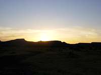
![Black Mesa sunrise]() Sunrise at Black Mesa
Sunrise at Black Mesa
We were the first people on the trail at 7:35, looking out for snakes but finding only deer and coyote tracks and droppings. The nearly flat trail curved back and forth through a valley between mesas, and we were unsure for some time which mesa was the one. What appeared to be the highest point in sight was actually in New Mexico. The trail finally turned and climbed toward the left side of a hill and then spiraled up to the right. We expected the highpoint to be right at the top, but learned that we had another mile to walk on top of the mesa before arriving at the actual highpoint. We reached the granite monument at the highpoint two hours after leaving the trailhead. We rested, took pictures, signed the log, enjoyed the view, and wondered if a tall peak we could see to the west was Wheeler Peak.
![Black Mesa ascent]() Black Mesa Ascent
Black Mesa Ascent![Valley beneath Black Mesa highpoint]() Valley Below Black Mesa
Valley Below Black Mesa
Half an hour later, we began the return hike. On the trail spiraling back down the hill, we could see some people approaching, and shortly thereafter encountered a couple hiking with another guy, their baby, and a Rottweiler. I believe they were from Norman, Oklahoma. We passed another couple on their way to the highpoint later, but did not stop to talk. We completed the 8.6 mile roundtrip at 11:44, taking slightly over four hours.
Capulin Volcano, then Wheeler Peak
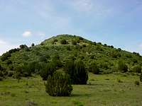
Back at the trailhead, we ate lunch, cleaned up, then looked over the maps and information for the highpoints of nearby states. We briefly considered going to Kansas first, but decided to go directly to New Mexico. We did not reutrn to the main highway. We drove west along 456, which was dirt for much of the way, and enjoyed the scenery. We came upon Capulin Volcano National Monument and decided to stop. It was a worthwhile stop. Capulin is a dormant cinder cone with a steep, narrow road spiraling up to its rim and a walking path from the rim into the crater. From the rim, there are excellent views of the valley below, other dormant volcanoes rising out of the valley, and the Sangre de Cristo Mountains to the west. We left Capulin along highway 64 to Raton and then to Taos. We saw hundreds of people on motorcycles along the way. The bikers seemed to have taken over everything from Cimarron to Taos.
![Volcanoes near Capulin]() Extinct Volcanoes Near Capulin
Extinct Volcanoes Near Capulin
We reached Taos around dinnertime and ate at a Mexican restaurant on the square where the food was not good and the service was worse. With the sun going down, we drove up the mountain toward Taos Ski Valley to search for a campsite. We found the Williams Lake trailhead beyond the ski resort and spoke with a young couple who were about to hike to Williams Lake to camp. They told us there was no camping at the trailhead, so we retreated back downhill. Luckily, there were still open spots in the Carson National Forest campground next to the ski resort. Setting up camp at 9200 feet left us out of breath, but the work kept us warm as the temperature dropped.
I slept very little that night due to the altitude. I gave up on sleeping at first light and was anxious to start hiking to Wheeler Peak. Casey apparently had no trouble sleeping though. By the time he emerged from his tent and we ate and readied our packs, it was after ten. We returned to the Williams Lake trailhead, where a hiker told us she had given up on the hike to the lake due to deep snow. We had doubts about reaching the summit, but began hiking anyway at about 10:40.
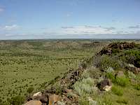
We immediately lost the trail and walked in a big circle around the trailhead parking lot. Trying again, we found the right direction and soon passed the Bavarian restaurant and a ski lift. Before long, we joined a line of other hikers on their way to Williams Lake. With knee-deep snow along the trail through the woods, we all tried to step in each other’s tracks to keep from sinking. We learned along the way that four others in our group planned to continue to Wheeler Peak. There were three locals – two men and one of their sons – and an older gentleman who we later learned was Bob, who had ridden his motorcycle from Corpus Christi, Texas. We reached Williams Lake around noon, rested, and took some pictures.
![Williams Lake]() Williams Lake
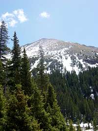
Williams Lake![Wheeler Peak from Williams Lake]() Wheeler Peak from Williams Lake
Wheeler Peak from Williams Lake
It was getting late in the day for a summit attempt at my anticipated slow pace, so I left the lake without waiting for the others. I thought Casey would catch me somewhere near the tree line. I believe that Bob left around the same time, followed by the locals and then Casey. The trail was very steep and I was having difficulty climbing through the deep snow until I managed to find a fallen tree branch that would make a good walking stick. The locals passed me near the tree line and slowly pulled away. Not far above the tree line, I saw the son glissading back down, leaving five for the summit.
The trail was very steep, with bluffs limiting visibility up and down the mountain. A large snowfield covered the fall line to the right, and sometimes crossed the trail, making climbing even more difficult. I followed the locals’ tracks through each snow crossing. A few more people came glissading down from the summit, giving positive reports on summit conditions. The steepness and the altitude forced me to rest every two or three steps and I was surprised that Casey had not caught me yet. I radioed him and found that he was about thirty minutes behind me. I could see a storm approaching and wondered how far I would get before the storm or fatigue forced me to turn back. Another radio call to Casey proved that he was not catching me, but I was not going to slow my pace. Just as I thought I was running out of time and would have to turn back, another hiker returning from the summit told me I was less than thirty minutes from it.
Encouraged, I made a final push for the ridge and reached it in fifteen minutes. The locals had just descended the ridge and congratulated me, as I would clearly reach the summit. Ten minutes later, around 2:50, I was at the summit. I signed the register, took in the incredible view, and called Casey on the radio to tell him I was there. He and Bob were climbing together and had crossed the snowfield to make a more direct ascent. He thought they were twenty minutes away. I took pictures of the view, and lay down in the windbreak to rest until Casey and Bob arrived. Two ravens appeared, hovering over the peak in the wind. One of them swooped down and nearly removed my hat. After twenty minutes, I called Casey again, but he estimated they were still ten or fifteen minutes away.
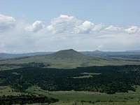
The storm was getting close, so I took pictures of myself with the US flag on the summit in case I had to leave before Casey arrived. Then I saw lightning. I radioed Casey to tell him the storm had reached the summit and I was leaving. He had cached his pack along his alternate route, so had to return the same way and would meet me at the tree line. I ran down the ridge and descended to the snowfield as quickly as I could. I glissaded down the snowfield using my walking stick to steer and brake.
![Storm approaching Wheeler Peak]() Storm Approaching
Storm Approaching
Before long, I saw Casey and Bob across the field. I continued my rapid descent and reached the tree line very quickly. When I radioed Casey to tell him I was there, I was shocked to learn that he and Bob were still climbing. Half an hour later, he called to say they had been hit by a blizzard and had to turn back just shy of the summit. Maybe another hour later, he and Bob finally walked into the woods. We all walked back to Williams Lake together and Bob continued down the trail as I stopped to snap a few more pictures.
Bob must have been moving quickly because Casey and I did not see him again on the trail. As we approached the trailhead, we were happy to see the Bavarian restaurant open with people sitting on the deck drinking beer. We were even happier to see that it was good German beer served by a cute German waitress. After a round of beer on the deck, we moved inside to eat dinner and found Bob already enjoying his. We exchanged contact information so we could later exchange photos, said our farewells, ate a great meal, and ordered dessert to go. Unfortunately, Casey left his sitting on the bed rail of the truck when we left the trailhead parking lot. He at least recovered some of it.
Another night of poor sleep preceded a long drive home through Santa Fe and Amarillo. Stanley Marsh’s Cadillac Ranch and numerous wind farms formed most of the scenery along Interstate 40. After three days without either, it was nice to get home to a shower and a comfortable bed.
Comments
No comments posted yet.