
-
 6076 Hits
-
 85.87% Score
-
 21 Votes
|
|
Mountain/Rock |
|---|---|
|
|
34.47896°N / 119.60252°W |
|
|
Santa Barbara |
|
|
Trad Climbing, Sport Climbing, Toprope |
|
|
Spring, Summer, Fall, Winter |
|
|
3200 ft / 975 m |
|
|
Overview
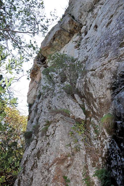
This one hundred and thirty foot formation is located across the road from Crag Full of Dynamite and a few minutes hiking distance down the hill from it. Most climbers aren’t aware that this rock is even there. From the road, all you can see is an insignificant pile of rocks down a sreep slope about a hundred feet away. Those few who have taken the time to go down to the base of Hermit Rock are always been surprised by its magnitude.

It is hard to understand the reasons why Hermit Rock has not captured the attention and imagination of climbers to the extent that it deserves. Several attempts have been made to bring Hermit Rock into the climbing main stream. Unfortunately, these efforts have been fruitless.
The earliest recorded climbing history on Hermit Rock dates back to the 1970s. Then for a number of years it fell into obscurity. In 1991, my friend Steve Tucker, the author of the climbing guide book to the Santa Barbara area, asked me if I would be interested developing a new area. I had never heard of Hermit Rock, and always looking for a new adventure, I agreed. Soon after, the group grew to about five people, and we all showed up with our gloves, scrapers, brushes and goggles.
 |  |  |  |
Climbs of Hermit Rock
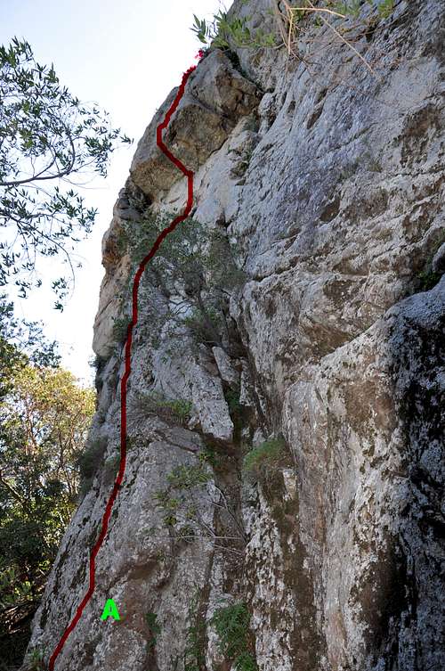
Hermit Rock, left Side showing Chunky Monkey, 11b

Hermit Rock-mid section showing {B- Battle of The Bulge, 10c, and C- The Wind Beneath Her Wings, 5.8}
It took about two weekends to have enough of the rock cleaned and scoped out for three possible routes. After all the prep work was done we started working on our routes.
I named my route “Chunky Monkey” a steep climb marked by a difficult overhang. Without the overhang, the climb would have been 10a. But the cruxy overhang brought the rating up to 11b.
Kevin Steele’s route went straight up the middle of the formation through a prominent bulge.
The bulge was the crux. He named it “Battle of The Bulge” and rated it 10c. The longest and the most modedrate climb was just to the right of Battle of The Bulge and it became Libby’s route. She named it “Wind Beneath Her Wings” rated at 5.8. Libby’s route was the most interesting one, climbing right past a very large abandoned bird nest. I think the only kind of bird that needed such a large nest must have been a Condor.
| A | Chunky Monkey, 11b, 4 bolts, Standard rack up to 2 inches |
| B | Battle of The Bulge, 10c, 4 bolts, and a standard rack up to 2 inches |
| C | The Wind Beneath Her Wings, 5.8, 6 bolts and standard rack up to 2 inches |
| Tabs, 5.6, climbs a slot corner to the right of route A, not fun | |
| The Recluse, 5.7, Combines the easiest parts of Routes B and C and uses a dirty trough to the top. This is the first documented climb of Hermit Rock. It was done by Steve Tucker in the mid seventies. |
Poison Oak

On my last visit to Hermit Rock I noticed some poison oak. I am not a doctor and this is not medical advice, however, a tip from a friend has saved my life many time for the past fifteen years. The tip is that if you rub alcohol where you think you may have come in contact with poison oak the oils will break down before they have time to penetrate the skin. I used to carry a small bottle of rubbing alcohol with me for that exact purpose. I am extremely allergic to Poison Oak, and I have not had any allergic reactions since I started this practice.
Camping
Unfortunately, there are no campgrounds close and convenient to Hermit Rock.
There is, however, one very large and well developed campground at Cachuma Lake, and a few less developed ones along Paradise Road off Highway 154. There are also a few campgrounds along Highway 101 at El Capitan State Park and Refugio State Park.
El Capitan Beach Camping
Refugio State Beach Camping
Cachuma Lake
How to Get There
From Highway 101 take the Las Positas off ramp. For those coming from the south turn right; for those coming from the north turn left. In either case, drive toward the mountains to the north of Santa Barbara. Continue up Las Positas for .85 miles to State Street, where the name of Las Positas changes to San Roque. Continue driving straight toward the mountains until you come to HWY 192 (Foothill Road) in another .5 mile. Turn right at the intersection and continue up Foothill Road for 1.9 miles to its intersection with Mountain Drive. Turn left onto Mountain Drive and drive for .5 mile to its intersection with Gibraltar Road. Gibralatr Rock is about five miles from this point. You will recognize Gibraltar Rock located to the west of the road when you begin to see a large sandstone formation immediately to your right (east side of the road). This formation is “The Bolt Ladder.” Gibraltar Rock is a little further up the road and to your left.
From Gibraltar Rock drive another two miles to its intersection with East Camino Cielo Road. Turn right here and drive six miles to Crag Full of Dynamite. Make a U-turn and park. A part of your car will be on the paved road.
You can drive a bit up or down the road and find a wider turn out, then walk back to the crag. If you look down the hill from Crag Full of Dynamite, you will see an insignificant pile of rocks a hundred feet lower from the road. Not to worry, your climbs are on the north face and you can approach them from the east side of the formation.