
-
 4111 Hits
-
 84.27% Score
-
 18 Votes
|
|
Canyon |
|---|---|
|
|
40.71468°N / 110.9953°W |
|
|
Hiking |
|
|
Overview
 South Rim
It is a strange out-of-the-way place which we've discovered by chance looking for the track of the lost hikers who perished here in 2003. No trails around here, but plenty of rock dropoffs, fissures, little waterfalls, grottos, and deep dry holes.
A little stream draining the hanging valley of Hidden Lake drops 500 ft into Mid Fork Weber River through a cliff-walled canyon which intersects with an array of dry canyons. From top to bottom, I named this side fissures A (on both sides of the stream), B (just to the South), and C (one-sided to the North and canyon-like to the South). There is also a separate dry fissure in the woods further to the North, if you believe the aerials ("X").
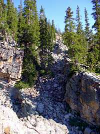 View along "Fissure B"
We still haven't found the location of the lost hikers' last rocky shelter (a grotto in a North-facing cliffs flanked by firs) despite criss-crossing this beautiful and treacherous three times. So far we've covered the main canyon and the entire fissure "A" on both sides of the canyon, most of "B", and the Northern end of "C". The rest of "C", and "X", are the next target of this mini-investigation. The hikers' last three identified photograps are all made at most half mile up the Hidden Stream from here, and the final location was described as a poorly accessible steep spot on the slopes of Mid Fork, at most 300 yards from a horse trail, so the tracks are hot! But we are still empty-handed, and your help is greatly appreciated.
Getting There
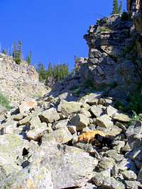 Approaching "Fissure C" from below
From down below (Mid Fork Weber River Trail)
Mid Fork Weber trail splits off the popular Long Lake trail at an unsigned cairned junction on the West side of the little meadow (which also contains a signposted Wir Lake junction at its East side, not 100 yards away). The somewhat indistinct (but throughly cairned and blazed) trail climbs to the NE and crosses Mid Fork divide just East of its lowest point, crosses the creek to its left (West) bank in half-mile, and drops into the floodplain in another half-mile. Along the usual Uinta creekside wetlands, the trail is in most parts to faint to follow as it continues downstream for three more miles to Abes Lake junction. There it becomes more popular and reaches Holiday Park TH in another couple miles. Three Divide lakes at the base of Mt Watson
The impossible-to-miss cliffs of Hidden Stream canyon country, and the stream itself just to the North, is in about two miles from either the Mid Fork Divide at the base of East Long or Abes Lake junction, and between 4 and 5 miles hike from either trailhead.
From up above (Clyde Divide)
A spur trail to Three Divide Lakes splits off trom the popular Clyde-Wall loop trail at the NW corner of Clyde Lake. The terrain is fairly open at this elevation, and as the trails fade shortly, it is easy to continue cross-country to the WNW. All the little streams draining from the divide come together at a long meadow stretching across the valley in a general S to N direction at 10,140 ft el, then rush into the canyon. Deepending on the exact route taken, the distance from Crystal Lake TH is between 4 and 5 miles.The track of lost hikers
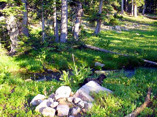
Although the lost hikers' last shelter location remains elusive - if tantalizingly close - we succeeded in locating the final two photographs retrieved from their camera. They have been made a short distance upstream from the canyon, and downstream from the outlet of Hidden Lake where the last of their previously identified photographs has been taken.The two last pictures have been taken from virtually the same spot on the right bank of the stream, near an old campsite on the East edge of a small meadow with the view of distant Long Peak.
"The Campsite": the next to last photo

 The "Campsite" location revealed!
"The Little Meadow": the last photo

 The "Little Meadow" location revealed
Red Tape and Camping
MLH parking permit needs to be purchased for Crystal Lake TH. On weekends the parking lot fills up quickly and tickets are known to be issued to illegally parked cars.Holiday Park is all private land except for the TH lot. Roadside parking prohibited.
The nearest campground is at Crystal Lake TH. For dispersed camping, stay 200 ft away from the lakes and streams, and obey the FS closures in the few more crowded areas such as Long and Clyde lakes.