


 or
or 


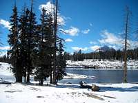

 The differences are too obvious though. The lone fir tree on Island Lake is
  Just as I kept claiming that the key "KSL images #19 and #20" couldn't have been taken at Hidden Lake,


 KSL - no number but according to the uploading order it may have been taken between Hidden Lake and the "Little Meadow".
desainme - Oct 23, 2006 4:02 am - Voted 10/10
Good matchesYou figured it out!

mtn runr - Oct 26, 2006 12:00 am - Voted 10/10
For Whom the Bell TollsAll of us who use this website should be "interested in real-life backcountry mysteries." I know I am. This Custom Object of yours is very compelling. I only wish it was still summer so I could go out looking for the mystery lake.

Dmitry Pruss - Oct 26, 2006 3:39 pm - Hasn't voted
Re: wish it was still summerThanks Grizz! Of course if it was still summer, I'd rather spend some time crisscrossing the beautiful backcountry there searching for clues than morphing the incomplete results into a page. Well, that will have to wait till next summer.

filwould - Oct 29, 2006 6:13 am - Hasn't voted
Mystery Photo 19We too have gotten caught up in the mystery route of these two ladies. After considerable time and evaluation my wife and I believe this mystery photo #19 (as you term it) is Hidden Lake. We analyzed 17 key position factors and land marks and feel very confident this is the place.
Dmitry Pruss - Oct 29, 2006 4:14 pm - Hasn't voted
Re: Mystery Photo 19Thanks for your comment. It was my "working hypothesis" too. But when we visited the lake two weeks back, we circled all around it and nothing was even close. South bank is kind of slow-slung and North Bank is a meadow. The only big wooded slope was on the East, and still nothing has any similarity. Most importantly, no peninsulas at all.
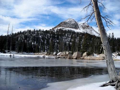
The one picture we took at Hidden Lake is the "title" image of my report BTW:

brendon - Oct 30, 2006 10:31 am - Voted 10/10
Re: Mystery Photo 19I would say that it is from the far west thumb of Hidden Lake looking northeast (basically corner to corner in this aerial photo. If you have the right position the following might line up: the lakeshore shape, stand of trees that touches the shore, thick timber behind, and narrow treeless gully coming off of West Notch.
No way to tell without going there.
Dmitry Pruss - Oct 30, 2006 10:04 pm - Hasn't voted
Re: Mystery Photo 19The aerial looks credible, and yet, I've passed the North shoreline of this little appendix of the lake twice, on the way to Mid Fork Weber and back. Never saw any points like in their picture. And this little outlet of a lake is just way too narrow.
Of course I should have made a photo, doh! But up until that point I was only photographing clear matches. Just didn't care about the guesses and misses yet :/ Hindsight 20/20 as always.
Yesterday I headed up there again to check Island Lake, but we only started noon-ish and just didn't have enough time to get to Hidden Lake again. The valley in the shade of Watson would be slow postholing, and I tried sticking to South-facing slopes instead, Made another picture of Hidden Lake from up the ridge, but it just isn't as informative as I wish...
desainme - Oct 31, 2006 8:22 pm - Voted 10/10
Re: Mystery Photo 19What about Deer Creek Lake? It has a peninsula- the USGS region is the Garfield region. Not so far from Long Lake
Dmitry Pruss - Oct 31, 2006 9:01 pm - Hasn't voted
Garfield? Re: Mystery Photo 19Desainme, the Long Lake you looked up is a different one, up Boulder Mountain in Garfield County, couple hundred miles out of the way to the SSE.
Interestingly, I started this object as a custom-type and then it had its very own coordinates and map links. I changed object type and the geographical info disappeared! My response was to put a few links to maps into the text, but maybe I just need a whole separate subsection with place names and Topozone / Google Satellite links? What do you think?
filwould - Nov 5, 2006 6:40 am - Hasn't voted
Re: Mystery Photo 19I am not sure how to attach the photo we took at Hidden Lake. Our analysis was done primarily with our eyes and the mystery photo #19 in hand. The tree that you see leaning on the right side of the picture in the fore front has since fallen down so that is why you do not see it in our picture. Also, our angle is a little to the right of theirs. But we studied the outcrops of land, the tall skinny pine on the farthest outcrop and the small tree to the left of it and they matched. The imbedded log in the closest outcrop was exactly (to the eye) as you see in the picture they took. Anyway, once spring comes perhaps we can all join forces and search a specific UTM grid.
Dmitry Pruss - Nov 5, 2006 4:42 pm - Hasn't voted
is it a digital picture?Very interesting! If you got a digitial picture, you should have no problem attaching it to this page. The "Add Image" link is up in the left-hand side bar, 3rd link from the top, you click "Add Image" -> "New".
BTW Mike Berry of WMC planes to lead a season-opener BC ski tour in the area next weekend (Nov 12th). If Ullr the Snow God is benevolent then we just might be able get a peek at this Hidden Lake spot before the winter shuts the road for good.
filwould - Nov 6, 2006 3:52 am - Hasn't voted
Re: is it a digital picture?Thanks for the help! We posted the picture as "Hidden Lake". See in the above Images Gallery.
Dmitry Pruss - Nov 6, 2006 2:23 pm - Hasn't voted
Unmistakeable!Time to re-write the story :) Thanks guys, you rock!
desainme - Oct 31, 2006 10:15 pm - Voted 10/10
I am always curious aboutmaps and you have an intriguing question. Good idea just to put the topozone link in there. Sorry to be so far off but I thought that elevation and lakes spelled Uintas in Utah. You have my interest.
Dmitry Pruss - Nov 1, 2006 12:10 am - Hasn't voted
Added an overview map with linksThe "other" Long Lake you picked is on Aquaruius Plateau, a pretty cool high-altitude lake country in its own right although no match to Uintas. It is mostly known for a county highpoint, which is an almost drive-up knoll amidst 11,000+ flats.
denalibound - Nov 2, 2006 12:55 am - Hasn't voted
Location of the shelter?It appears the location you have on your map is much further north than what KSL has. The KSL map at the bottom of their story shows the shelter location as being just off the trail between Hidden Lake and Jerry Lake. Do you know which one is correct?
If I were to bet, I would say the mystery picture is from Hidden lake as Brenden describes. However as the photo progression goes it appears, near the spot where the picture was taken there is a small water fall (charecterized by the waterfall picture splitting two pictures from the same vantage). If you find locations where there are dranages into the possible lakes you may be able to find the spot where the mystery photo was taken.
I also believe it is posible the final picture with no number is taken from relatively the same spot just facing south to Mount Watson. But I live 500 miles away, so I will trust those of you have been there.
Dmitry Pruss - Nov 3, 2006 2:23 am - Hasn't voted
Re: Location of the shelter?Both maps are probably wrong, the location I show is from Shane's website (climb-utah) and that one in turn is from the local papers back from 2004. The KSL map shows a location due West of Hidden Lake & we've checked this area relatively thouroughly this October. All I know for a fact that it is somewhere in Mid Fk Weber - which spans many square miles. The KSL shelter image, and the (inconsistent) tidbits from the media on the attached page, might help to narrow down the possibilies.

desainme - Nov 7, 2006 5:46 am - Voted 10/10
Your picturefrom Watson across Hidden Lake to West Notch Mtn. looks pretty convincing to me. The Topozone is too coarse to pick up the detail of the southwest cove of the little lake. A tall conifer out on the point says this is the right place. The hikers probably would have lived had the snow not been preceeded by a cold rain.

Scott - Nov 8, 2006 3:59 pm - Hasn't voted
HiddenSo, it was Hidden. Good to know. Anyway, it appears that they must have gotten north and south mixed up and thought Notch Mountain on their right was Mount Watson, and thought they were heading south instead of north?
Dmitry Pruss - Nov 8, 2006 6:44 pm - Hasn't voted
Must have gotten N and S mixed up?I don't think it is possible to mix up the things this way if their plan was to return from Clyde to Crystal Lake TH. There simply isn't supposed to be a mighty big mountain to your left if you head down to the car. And the visibility was pretty good when the pair passed Clyde Lake. They would have Watson towering on their left all the time. Even the worst maps show it, and the trails get pretty faint past Three Divide Lakes so if one hasn't checked a map until then, this would have been the right time.
What if the women planned to continue through the Notch on Notch Mountain Trail, and thought Clyde Divide was the Notch???
As a side note about the quality of their routefinding... the pictures show they reached Wall Lake by loosing the main trail and following unofficial tracks (just take a look at their picture with Reids Peak ... it is taken from a track in between Notch Mtn Trail and Cliff Lake). But of course navigation between Wall and Cliff is in the thick woods and it's not hard to miss a turn - and not a big problem if you do.
Miss-navigating a widely open terrain around Clyde Lake is a completely different business.
Comments
Post a Comment