
|
|
Mountain/Rock |
|---|---|
|
|
39.54450°N / 79.0969°W |
|
|
2991 ft / 912 m |
|
|
Overview
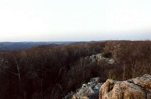
Maryland's mountains are not known for their sweeping vista view. That is what makes this summit so special. It is not a clear-cut or a power-line but an actual ledge filled with some of the best panoramas in the state. The summit is also not very popular due to the fact that it is a very confusing drive to get to the trailhead. Still, the views on this summit rank it in the top three for views in western Maryland.
 The summit area
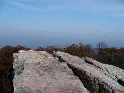
The actual summit, which consists of a fire tower, beautiful ledge and bouldering area is the high point on the long ridge of Savage Mountain. From the summit you can view Mt. Davis to the north and Backbone Mountain to the southwest. From the other side, the paper mill town of Westernport is clearly visible. The fire tower opens up views in the region even more though it seemed to be in disrepair back in 1999.
The easiest way up this gem is via the High Rock Fire Road (block for hiking only). The 2.0 round-trip consist of high up a moderate to steeply pitched road (still easily class one) to the summit fire tower and ledge. The rock also makes a great stop on the Savage Mountain Trail, which spans 17 miles over the mountain.
 |
 |
 |
 |
Getting There
HIGH ROCK TRAILHEAD: From Exit 29 off Interstate 68. Head South on Beall School Road to the end. Make a right on Old Frostburg Road. Make an immediate left on Frostburg Road. Stay on Frostburg Road to the very end. Make a left on the Avilton Lonaconing Rd. Go roughly two miles on the Avilton-Lonaconing Road. Make a right on Swamp Road. Take Swamp Road over the ridgeline (good views off to your left) to the very end. Make a left on Westernport Road. Stay on the road past Pine Swamp road where it will become a dirt road. Roughly a mile past Pine Swamp, High Rock Fire Tower Road (blocked unmarked) will be on your right with parking on left.
Red Tape
This is wildlife conservation area. Obviously use a carry in-carry out philosophy in this area. There is no parking pass for the area and there is no fee.
Weather Conditions
Here is a link to weather near High Rock.
When To Climb
This summit can hiked at any time of the year. No season hear is any prettier than another.
Camping
There is a small camping area on a side trail roughly 200 feet from the top (no fee). The side trail link back with the fire road below. Campfires are illegal on the summit.
Mountain Conditions
There is limited information on this summit. Best site I have seen is this one
Here is another link to Savage State Forest . Note that the Savage Mountain starts at the Savage River Reservoir.
Summit Picture Log
Post your summit mugshot here.