
|
|
Route |
|---|---|
|
|
47.42611°N / 10.36088°E |
|
|
Via Ferrata |
|
|
Summer, Fall |
|
|
Half a day |
|
|
KS 3, Rock difficulity I-II |
|
|
II |
|
|
Overview
The Hindelanger Klettersteig is one of the most famous via ferratas and ridges in Germany.
The ridge is sharp and you have a great view to about 400 mountains in the Alps (f.e. Zugspitze, Lechtaler Alps, Schesaplana and other swiss mountains).
The via ferrata was built between 1973 and 1978 and was modernized in 2003.
Be careful of thunder storms. This can be deadly at the ridge! There are 2 "emergency descents" - use them if bad weather comes!
Getting There
The town in the valley is Oberstdorf (815 m).You can reach Oberstdorf by the Autobahn A7 and 30 km highway at the end.
The highway was enlarged in the last years.
Distances:
Stuttgart 250 km , 2 1/2 h
Munich 190 km , 2 h
Innsbruck 160 km , 2 h 15 min
There is a good connection by public transport.
By train you have a excellent connection between Dietmannsried, Kempten, Martinszell, Immenstadt, Blaichach, Sonthofen, Altstädten, Fischen, Langenwang and Oberstdorf.
By Interregio-train you also have a good connection in the morning and in the evening from Stuttgart and Munich.
You can use buses which oscillate between the parking places before Oberstdorf and many places in Oberstdorf (between 08:00 and 18:00).
The bus is cost-free if you have a guest card (when you stay minimum 2 days in Oberstdorf).
The via ferrata starts at the top of the Nebelhorn
(2.224 m).
In Oberstdorf (815 m) you can take the ropeway to Nebelhorn
(2.224 m, 25 Euro p.p. in 2006) via station "Höfatsblick".
In 25 minutes you are nearly on top of Nebelhorn. In 2 minutes you are on the top (summit cross) with a great view.
You have also (the much more beautiful alternative) to hike to the Nebelhorn from Oberstdorf via Seealpe (3 1/2 h) or via Geißalpe (5 1/2 h, great hike). Other possibilities are the hike via Oytal and Gleitweg (3 1/2 h, cumbersome) or from Hinterstein via Giebel hut and Zeiger (5 1/2 h, nice ascent).
From Edmund-Probst-Haus in 30 minutes to the top of Nebelhorn.
The via ferrata starts at the Nebelhorn.
You can see nearly the complete ridge via Westlicher Wengenkopf and Oestlicher Wengenkopf to Grosser Daumen.
It is also possible to start the via ferrata at the Grosser Daumen. You reach Großer Daumen from ropeway station "Höfatsblick" and Edmund-Probst-hut in 3 hours.
Route Description
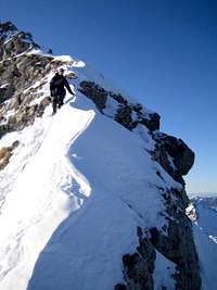
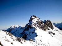 View to the ridge from Nebelhorn View to the ridge from Nebelhorn |  sharp ridge sharp ridge |  vertical passage vertical passage |
|---|
The route mostly runs exactly at the ridge, sometimes a few meters right of the ridge.
A rope is only at the most difficult parts, many parts are unsecured and the abyss under these parts needs climbers who are completely free from giddiness.
At the complete ridge you climb from summits to nicks and from nicks to summits, so the route is really big fun.
From top of Nebelhorn you first have some meters of hiking then the first easy climbing passage (with rope) starts.
Then the ridge is getting sharper and you have to climb some parts without a rope (difficulty: I-II).
After some ladders and diversified climbing you reach the Westlicher Wengenkopf (2.235 m, with summit cross). The first meters after the Westlicher Wengenkopf are easy, then an airy part (no rope) follows. Then you climb down vertically to a nick by two ladders.
After the ladders you have the possibility to end the via ferrata and hike down to Koblat and back to the ropeway.
The ridge gets more airy and mory challenging then. A long ladder, a cutting. Now airy passages and easier passages alternates.
Before taking the ladder to Oestlicher Wengenkopf there is another possibility to leave the ridge and to hike down to Koblat and back to the ropeway.
The via ferrata ends in the nick between Oestlicher Wengenkopf and Großer Daumen. On the right sight you have a great view to the Koblat lake and Laufbichel lake.
For the via ferrata you need 3 - 3 1/2 hours in each direction. But in summer there is much traffic on the ridge so it also could take more time.
.
Descent
4 possibilities to descent:a)
From the Großer Daumen to the nick near Östlicher Wengenkopf (sign post "Giebelhaus - Edmund-Probst-Haus") and then hiking idyllic back to the ropeway station and the Edmund-Probst-Haus: 2 1/2 h
b)
Via Großer Daumen and Kleiner Daumen you go west via the Haseneckalmto the Rettenschwang valley. Then on a road (no cars allowed) to Bad Oberdorf and Hindelang.
c)
Via Großer Daumen and Kleiner Daumen you go east the the Engeratsgund lake and on trails to Hinterstein.
d)
Via Großer Daumen and Kleiner Daumen you go west to the Obere Haseneckalm and on a small trail you climb to the Rotspitze. Then you can continue the via ferrata "Hohe Gänge" (easier than via ferrata Hindelang but a very long climbing day!).
Essential Gear
For climbing the via ferrata in summer use a via ferrata kit.Winter ascent
Climbing the ridge in winter is very difficult.There are big crevasses, the ropes are often under the snow and you have no possibility the get the rope.
The ridge is very sharp and full of snow and the rocks are icy.
If you fall you fall deep! So be careful!
 sharp ridge sharp ridge |  A lot of fresh snow A lot of fresh snow |  On the sharp ridge On the sharp ridge |
|---|