|
|
Mountain/Rock |
|---|---|
|
|
41.71501°N / 121.53136°W |
|
|
Hiking, Bouldering, Scrambling, Skiing |
|
|
Spring, Summer, Fall, Winter |
|
|
5493 ft / 1674 m |
|
|
Overview
Difficulty: Class 2 as there is no trailDistance: 0.70 miles round-trip
Elevation Gain: 560+ feet
Claiming the title of the tallest point in Lava Beds National Monument, and almost directly South of Schonchin Butte lies a short little scramble called Hippo Butte. The climb starts from the side of the road and follows no particular trail. Basically it is a scramble up the East side of the Butte. Loaded with scree, this less than 1 mile round trip climb can be done easily as far as technicalities go but mildly tiring due to the two steps forward one step back that you get with most scree. As well as dealing with the scree, you climb 560+ feet in 0.35 miles, so there is a pretty decent elevation gain involved. Hippo Butte is easily identified by the decent sized lava plug sticking out of it.

Getting There
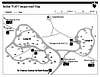
If Coming from the South: From I-5 take Highway 97 north at the city of Weed to a right turn on California Hwy. 161, also known as Stateline Road. Travel east on CA 161 through the Lower Klamath National Wildlife Refugeto Hill Road. Turn right on Hill road at the West End Grocery Store, following Lava Bed monument signs. Travel south on Hill Road 10 miles until you enter Lava Beds National Monument.From the Klamath Falls area: Take Oregon Hwy 39 south approximately 20 miles until it enters the town of Merrill, OR. Approximately one mile south of Merrill, turn right (south) on Malone road. Travel south on Malone road approximately 2 miles until you reach Stateline Road 161. Turn left (east) and then take the immediate right at West End Grocery Store onto Hill Road. Travel south on Hill Road 10 miles until you enter Lava Beds National Monument. You will pass the visitor center for Tulelake National Wildlife Refuge on your way to the monument.
For those traveling east on California Hwy 299 from the Redding or Lassen National Volcanic Park areas, travel north at Bieber on Hackamore / Lookout Road (closed in winter) to California Hwy 139. Travel north on CA 139 until meeting directional signs that will direct you to the monument at a left turn. NOTE: This south entrance into the park is paved, but in very poor repair. Drive slowly and carefully around the potholes. The Forest Service is hoping to repair it, if funding is available.
If coming from Medford, OR: Follow the Crater Lake Highway 62 off of Exit 30 until you see signs for Highway 140. Follow Highway 140 East for about 65-70 miles until you reach Klamath Falls. From there follow the same directions as above to reach Schonchin Butte.
Once at the Monument, you will take a right at the Medicine Lake pointer. If you have reached the Visitor's Center than you have gone too far. Once on the road to Medicine Lake, you will see Hippo Butte off to your right hand side. Not far up this road, probably less than half of a mile, there will be a road off to the left hand side that should be gated. You can park here as your starting point for the climb. There is only space for maybe four cars at the very most here.
Red Tape
Passes are required for entrance into Lava Beds National Monument. You must have or purchase one of the following:Seven Day entrance fee - $10
Motorcycle, Bicycle or Walk-in - $5
Campsite Fee - $10
Group Campsite Fee - $3 per person up to $60
Lava Beds Annual Pass - $20
America The Beautiful (National Parks and Federal Lands Recreation Annual Pass - $80
Senior "America The Beautiful" Pass (Lifetime) - $10
Golden Age Passes will still be honored for life
Disabled - Golden Access Pass - FREE
Purchase your "America The Beautiful" Pass here: Click here
No Hunting is allowed within the monument.
Please check with the visitor's center regarding fire conditions and restrictions.
When to climb
WINTER - Hippo Butte can be climbed any time of the year. On Average, Lava Beds National Monument doesn't get an awful lot of snow. The road leading to the Ranger Station is plowed during the winter months, so even if there is too much snow on the road leading up to Hippo Butte, one could easily pull into one of the obvious viewpoints close by and just add a mile or two to the climb. I must add that my wife and I climbed nearby Schonchin Butte right after a snow storm in the middle of January and were able to reach the trailhead without much difficulty, although we did put on some chains and all we drive is a little passenger car.Snowshoes may be something you would want to add to your list of things to bring when climbing this peak but we did just fine climing in snow that was a couple of inches deep. I don't feel an ice axe is warranted, unless you plan to hunt a rabbit with it. Crampons may come in handy if it gets really icy, but still probably unneeded but you should pack them just in case.
SUMMER - During the summer months the trailhead is easily accessed. Just take the necessary precautions (i.e. Sunscreen, sunglasses, plenty of water, watch out for rattlesnakes) as temperatures can easily reach near or above the 100 degree mark.

Camping
Camping is allowed in Lava Beds National Monument.For more information, click here
When camping any time of year, please be prepared for exposure. The camp areas are very open with not much shade or cover. Thanks keema
Mountain Conditions


Click the Satellite picture for a video loop of current weather
Webcam

2skinners other Mountain Pages
Feel free to check out my other mountain pages and pictures as well. CALIFORNIA MOUNTAINS:
Red Buttes
Schonchin Butte
 DELAWARE MOUNTAINS (HIGHPOINT):
Ebright Azimuth
 OREGON MOUNTAINS:
Bolan Mountain
Crater Lake Caldera
Grizzly Peak
Lower Table Rock
Mount Ashland
Mount Thielsen
Soda Mountain
South Sister
Upper Table Rock
 WASHINGTON MOUNTAINS:
Discovery Peak
Colonel Bob
Mount Pilchuck