
-
 27037 Hits
-
 83.69% Score
-
 17 Votes
|
|
Mountain/Rock |
|---|---|
|
|
40.46500°N / 121.5447°W |
|
|
9087 ft / 2770 m |
|
|
Overview
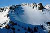
 Brokeoff Mountain looms beyond Mt. Diller and Eagle Peak
Mt Diller is a splendid one-day climb and is excellent for ski tours. It is located in the Lassen Volcanic National Park. The round trip from Highway 89 at Sulfur Works (6,900’) to the summit (9,087’) is 4 miles, however there is not an established trail to the top for a summer ascent. A trail goes to Ridge Lakes, which is about half way to the top. From here it is a scramble. Mt Diller is a more popular winter ski touring destination. During the winter, Mt Diller can be approached from either the west or the east sides of Sulfer Works. Both the northern and southern slopes off of the summit offer excellent ski and snowboard descents. Views from the summit are of Mt Shasta to the north, Mt Lassen to the northeast and Brokeoff Mt to the southwest.
Mt Diller is located on a ridgeline connecting Mt Lassen to Brokeoff Mt. This ridge linking Brokeoff and Lassen also includes Pilot Pinnacle, Ski Heil Peak and Eagle Peak. It is possible to make a ridgeline traverse linking Brokeoff to Lassen. This traverse would involve a few technical sections.
Mt Diller is one of the last remaining remnants of a large volcano called Mt Tehama that was at it’s maximum height and girth around 300,000 years ago. Mt Tehama was a stratovolcano that was about 11,000’ and similar in size and shape to Oregon’s Mt Hood. Because of it’s existence during the Ice Age, Mt Tehama was heavily carved away by massive glaciers which left only fragments that are now today Mt Diller, Mt Conard to the southeast and Brokeoff Mt to the southwest.
 |  |  |
Getting There
To reach the Southwest entrance station, which is the closest entrance to Mt Diller, take the northern most of two exits off of I-5 for Red Bluff and head east. Red Bluff is about 30 miles south of Redding. After about a mile, toward the edge of town, turn left/east on to Highway 36 and the sign for Lassen National Park. In about 40 miles you will reach the town of Mineral. 5 miles past Mineral turn left/north onto Highway 89 into Lassen National Park. Proceed for about 6 miles, passing the Southeast entrance station to an area called Sulfer Works with a parking lot on the left. Park here. From here it is about two miles to Mt Diller which is located directly north/northwest of Sulfer Works.Due to snow during the winter, Highway 89 is closed just past the Southwest entrance station at the Lassen Ski Chalet. Park at the Chalet and proceed up the snow-covered road for about a mile to Sulfer Works. This area is very apparent during the winter as steam rises year-round and there is no mistaking the smell of sulfur.
A parking pass is required to park within park boundaries year-round. Use a National Parks Pass to obtain the parking pass or purchase a seven-day pass for $10.
Red Tape
A backcountry permit is required year round for all overnight trips. Permits can be obtained from the Southeast entrance station, the Loomis Museum located at the Northwest entrance station, from the parks office in Mineral, or from the Almanor Ranger District in Chester.A parking permit is required to park within park boundaries.
When To Climb
The best summer months for climbing are from June through October. For winter ski touring, December through April are the best months to climb Diller.Camping
There are 33 campgrounds in or around the Lassen National Park for a total of over 1000 camp sigts. 8 of these campgrounds are within Lassen National Park and are on a ‘first come, first serve’ basis. Each of these campgrounds have fees and do not offer reservations. The closest campground to the Mount Diller is Southwest, located just inside the Southwest entrance station.Backcountry camping is allowed by permit only.
Lodging can be found at one location within the park and at a number of locations in Chester.
Mountain Conditions
For weather in the Lassen Volcanic Park click here or check the National Weather Service.For information on road conditions check Caltrans.
For information on snow pack check here.
For information on avalanche conditions check here.
For more information on Lassen Volcanic Park click here, here or here.
keema - Jul 27, 2004 9:55 pm - Hasn't voted
Untitled CommentLassen Volcanic National Park now takes reservations for some campsites. Loop A at Manzanita Lake, Lost Creek Campground, and loop B (North Summit Lake) and C and D (South Summit Lake). Loop E at South Summit Lake is tents only. Reservations can be made by calling 877-444-6777.