
-
 7558 Hits
-
 79.04% Score
-
 10 Votes
|
|
Mountain/Rock |
|---|---|
|
|
47.10434°N / 10.73167°E |
|
|
Hiking |
|
|
Spring, Summer, Fall |
|
|
9117 ft / 2779 m |
|
|
Overview
- the Wetterstein range with the Zugspitze in the north east
- the neighboring Geigenkamm ridge in the east
- the entire Kaunertal valley and a few of the Ötztal main ridge peaks including the Weißseespitze in the south
- Italy and the Silvretta range in the south west
- the Lechquellengebirge range in the west
- and virtually all of the Lechtal Alps highest peaks in the north.
Google Maps Loading...
(this could take up to 30 seconds)
(this could take up to 30 seconds)
Getting There
The shortest and most easily accessed trail starts at the Piller Höhe (1,559m). There's a visitors center called "Naturparkhaus Kaunergrat" (opened in 2007) and plenty of parking. Use Google maps for directions.Since 2010, there's public bus service called "Naturparkbus" from the towns of Landeck and Fließ to the Piller Höhe 3 times a day between June and September. You can find the schedule on kaunergrat.at (in German). The PDF file offered on that site ("Fahrplan Naturparkbus") includes a few train connections to Landeck from Innsbruck.
Hiking Trail
The trail from the Piller Höhe to the summit of the Hohe Aifner Spitze is about 8km/5miles long with a total elevation gain of 1,200m/3,940ft. Plan in around 3.5h for the ascent.There's a forestry road (gravel) that starts at the southern end of the parking lot at the Piller Höhe, with a signpost hiking map right at its start. First way point is the "Aifner Alm" which is a serviced hut at 1,980m/6,496ft (plan in a break on the ascent or descent!). To get there you can either: 1) follow the forestry road for about 3km/1.9miles on flat ground before turning right onto an uphill forestry road (follow signs to Aifner Alm), or 2) follow the signs to the Aifner Alm via a trail through the forest (which is a bit longer). Both trails ultimately join again.
In variation 1), when the uphill forestry road ends, a smaller trail starts left-ish. Continue through forests, occasionally crossing and partly hiking on further forestry roads. Always follow the signs. At some point the forest gets less dense and you end up first on an older forestry road which then joins a bigger one. From here it's only a few more minutes to the Aifner Alm hut.
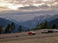 Parking lot at the Piller Höhe, seen from the trailhead (beginning of forestry road).
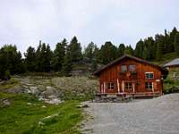 The Aifner Alm at 1,980m/6,496ft.
 Rugged alpine bush landscape.
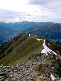 Loose ground on the final section below the summit.
From the Niedere Aifner Spitze it's around half an hour to 45mins to the Hohe Aifner Spitze. The path is obvious. You follow a saddle without much elevation gain past an emergency shelter right on the saddle before the trail ascends the final slopes of the Hohe Aifner Spitze. Though not difficult, you should be sure-footed on this section: It's rather steep, in parts a bit exposed, with some steps and sometimes loose ground. You'll occasionally end up using your hands for balance, but it should be doable for every hiker. Make sure you take your time here especially on the descent as a fall could be fatal.
The summit is spacious enough. Pick the most appealing boulder to sit on and enjoy the view! Both the Niedere and Hohe Aifner Spitze have summit registers.
For the descent follow the same trail back.
 Westward view from the summit. The Niedere Aifner Spitze in the foreground.
The trail follows the ridge. You can see the meadows of the Aifner Alm below.
 Looking south into the Kaunertal valley from the summit of the Hohe Aifner Spitze.
Red Tape
No permits required.External Links
- Map and GPS data on alpintouren.com
- Hohe Aifner Spitze Wikipedia page (in German)
- Kaunergrat Nature Park
- Piller Höhe on Google maps
- Naturpark Kaunergrat: Naturparkhaus (in German) with info on public transportation.
- Cafe-Restaurant Gachenblick im Naturparkhaus Kaunergrat (in German) with additional info on the exhibits.