
-
 5206 Hits
-
 75.81% Score
-
 6 Votes
|
|
Route |
|---|---|
|
|
47.35848°N / 11.01272°E |
|
|
Hiking |
|
|
Fall |
|
|
A long day |
|
|
UIAA grade I / II and easier |
|
|
I |
|
|
Overview
 Hohe Wand from Hohe Munde - overview (10-10-2004)
Hohe Wand or Hochwand is a prominent summit of the Mieminger range which is located south of the Wetterstein range and north of the Valley of river Inn.
The Mieminger range stretches in west - east direction for about 20 km with some minor ridges to the north.
Hohe Wand reaches a hight of 2721 m and makes so the 4th highest peak of the range. To the north the Gaistal valley is 1400 m deeper, to the south Innvalley is 2000 m away. The east ridge ends at Niedere Munde (2055 m), the traverse to Hohe Munde summits, which form the eastern end of the range.
The western ridge goes to Hochplattig, the highest peak of the range, the lowest point on this traverse is Alpl Scharte (notch), 2313 m.
From the Leutasch valley in the east, the Hohe Wand northeast wall is a tremendous viewpoint.
The easiest way up to Hohe Wand is via southeast ridge trail. This is what this article is about.
Getting There
 Inntal valley
The trailhead is located at about 1160 m in the woods above the village of Telfs. Telfs is located in the Inn valley.
You reach Telfs via the Inntal Autobahn from Innsbruck or Arlberg / Imst region, exit Telfs.
From Munich you reach Telfs via Garmisch-Partenkirchen, Mittenwald, Scharnitz / Austria and Seefeld. At Seefeld, follow the direction Mösern and Telfs.
To reach the trailhead, choose Dandlweg and Hinterberg in the eastern part of Telfs and follow the road to Lehen. Go strait on into the woods. The road becomes a dirt road now, don´t worry. After some switchbacks you reach the parking area at Grieslehn, Lucke. There are two parking areas so use the first only if the second is complete which will rarely happen.
In 2004 there was no parking fee but you never know ... better to pay if there is a fee required now.
Route Description
 Hohe Munde (10-10-2004)
From the parking area follow the forest road to a meadow and the Strassberghaus, a private mountain lodge.
Follow the road strait on, direction Neue Alpl Hütte. Neue Alpl Hütte is a nice mountain hut wich lies hidden in the woods of Alpl valley at a hight of 1506 m. It is a good place for a beer (or two - if you don´t drive) when coming down from the summit.
At Alplhaus there is a junction to Niedere Munde to the right. For Hohe Wand follow the trail straight on for a while. It is marked with red dots. After about 500 m turn right. The trail climbs up to Hintereggen, the southeast ridge of Hohe Wand. The trail reaches the ridge at about 1800 m and follows the ridge strait up. The trail becomes really steep now and you have to do some easy rock climbing.
At about 1950 m you arrive at the trail junction to Kleiner Karkopf (2471 m), a minor summit in the eastern ridge of Hohe Wand. This trail makes a traverse through "Karseite" and leads up through the rocky southwestslope of Karkopf to its summit. The ascent is easier than Hohe Wand and much less far - it can be an alternative for a "bad shaped day" :-)
But lets follow the Hohe Wand trail. A grassy and rocky slope leads up to 2400 m where the trail turns left to avoid a difficult wall in the ridge. There is a steep climb with rock and loose scree and finally the trail reaches a series of shallow rocky chutes and walls. The red dots lead the mountaineers through this impressive part of the ascent. You need to know how to handle UIAA grade I / II and exposure.
 Rock scramble (10-10-2004) Rock scramble (10-10-2004) |  Rock scramble (10-10-2004) Rock scramble (10-10-2004) |  Rock scramble (10-10-2004) Rock scramble (10-10-2004) |
The trail ends at a "nose" in the southern ridge of the summit, above this nose there is the impressive summit cross (2715 m). The highest point of the Hohe Wand is some steps further northeast. If you want, follow the ridge to this point.
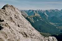 View to the east (10-10-2004)
The scenery and views are breathtaking and worth the trip. You normally will meet only very few people, mainly people from nearby villages.
To the north is the impressive wall of the Wetterstein range with Zugspitze to the northwest, the highest point of Germany. To the west stretches the inumerable summits of Allgäu, Lechtal and Verwall area. To the east dominates the Karwendel group. To the south, southeast and southwest is the sparkling diamont necklace of Austrian glaciers: Großvenediger, Zillertal, Stubai and Ötztal area.
 Allgäu range view (10-10-2004) Allgäu range view (10-10-2004) |  Hochplattig and the Mieming range (10-10-2004) Hochplattig and the Mieming range (10-10-2004) | 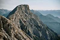 Hohe Munde (10-10-2004) Hohe Munde (10-10-2004) |
The descent is on the same trail. Beware of loose rocks, the rock quality in the Miminger range is not very good.
 Summit cross (10-10-2004)
The traverse from Hohe Wand to Kleiner Karkopf should be UIAA grade II, and you return via Karkopf trail to the trail junction on the southeast ridge. I think you need a rope and more rock experience for this traverse. Because of the loose rocks everywhere I recommend to go this traverse from Karkopf to Hohe Wand.
Essential Gear
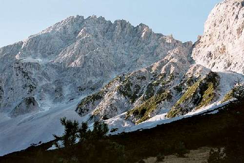
 Dreitorspitzen (10-10-2004)
Helmets are recommended for the upper part because of the loose rock.
Ropes normally are not required. Children and people with fewer experience maybe roped during the upper more difficult part of the trail.
External Links
 View to Inntal valley (10-10-2004)
Neue Alpl Hütte in the Alpltal Valley - a place to stay
Other recommendations
 Hochplattig (10-10-2004)
This hike is not recommended after heavy rain and during bad weather or thunderstorm conditions because of its steepness and exposure.
If you want to pass an interesting weekend, stay one night at Neue Alpl Hütte and go for Hochplattig via Judenkopf chute and southridge the next day (UIAA I and easier).