
-
 10922 Hits
-
 80.56% Score
-
 14 Votes
|
|
Mountain/Rock |
|---|---|
|
|
47.35890°N / 11.01540°E |
|
|
8921 ft / 2719 m |
|
|
Overview
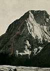
geographical classification: Eastern Alps > Wetterstein / Mieming Ranges > HochwandHochwand is a prominent peak in the Mieminger Mountain Range, that is south of the more famous Wetterstein range with Zugspitze. Most impressive about Hochwand is its north face that breaks down more than 1300 meter to the Gaistal valley, while the mountain is less steep on the south side that carry the normal route. But rock quality on the normal route is not very good - exposed scrambling on easy but fragile rocks is required and orientation is really a problem if fog occurs. So Hochwand is not that often climbed.
On the north side rocks are better than usually in Mieming Mountain Range, especially on the ridge-routes. But alle routes are very long and require a experienced and trained rock climber and are not at all easy and well protected "plaisir climbs". Because of its seclusion in connection with the tallness of the wall, the routes are some of the big challenges in the northern limestone alps.
The mountain has two summits: the NE summit (2719 m) and the SW summit (2715 m) with a distance between of 200 m.
First climber was famous mountain explorer Hermann von Barth on August 9th 1873
 |  |  |
Getting There
Nearest airport is Innsbruck.For the normal route you have to follow the Inntal motorway, exit Telfs, then following the main road direction Nassereith-Fernpass up to the Mieming plateau, but branch of after 5 km at Affenhausen to the little village of Wildermieming (872 m)
For the north routes the place to go is the village of Leutasch, to reach
- from Germany via Mittenwald
- from Innsbruck via Seefeld
Approach
south side (normal route)From Wildermieming 2 h fine and easy walk (marked trail) to Neue Alplhuette hut (1504 m). - a nice goal for hikers and very fine in late spring or fall.
north side:
From the parking lot in Leutasch you have to walk - or take your bike - to the start of the climb (app. 10 km!).
Camping / Accomodation
There are official campgrounds in Leutasch. And there are many hotels in tourists villages of Leutasch and Mieming. There is a alpine hut in the Gaistal valley - Tilfussalmfor the normal route it is recommendable to stay the night at Neue Alplhuette (1540 m). This is a private hut, guided from June to October. 24 places, Tel. 0043-676-7209100.
for the north routes lodging is possible at the private hut Tillfussalm (1382 m) in Gaistal valley, Tel. 0043-5214-6297
Routes Overview
according to guidebook form Rudolf Wutscher, "Mieminger Kette", Bergverlag Rother, 1989- south slopes, normal route, UIAA I-II at some parts and exposed, no fixed ropes, exhausting, but very well marked with red spots so orientation isn't a problem at all, 1200 m ascent from Neue Alpl Huette, 4 h. The route reaches the SW summit.
- SE ridge; UIAA II, done as a traverse from neighbor mountain Karkopf; Ampferer, Hammer, Greil, 08-23-1894
- SW ridge, UIAA III; 2 h from Alplscharte notch; O. Ampferer, G. Beyrer, 09-25-1897
- NW ridge, UIAA IV, 1150 m elevation gain climbing, 6 h; upper part A. Knoepfler, 1917
- NE ridge, UIAA IV, 1000 m elevation gain climbing, 6 h
- N-face "Schoellkar", UIAA V; P. Lammerer, E. Mueler, 09-04/05-1963
At "Tote Wand" an upright rocky section of the south side of the mountain
- S-face dihedral, UIAA V; H Föger, H. Hildebrand, 09-11-1946
Red Tape
There is a parking lot at the trailhead in Leutasch. They charge is 3 Euro per carWhen To Climb
summer as soon as there is not too much snow left. For the north routes you need a long summer day, the normal south route can be done until the first snow occurs again.Maps / Books
best map available is the one from the german/austrian alpine club, "Alpenvereinskarte" Nr. 4/2 Wetterstein- und Mieminger Gebirge Mitte 1:25000guidebook in german: "Mieminger Kette" by Rudolf Wutscher, Bergverlag Rother, Munich, 1989