Battle plan for "Victory in Three Days"
Day Number One: When one contemplates an elevation gain of at least 10,400’ in one continuous push, one must consider several things, not the least of which is one’s sanity. Given the fact this route has been completed by many reckless souls, whose names are not inscribed on tombstones as far as we know, the thought becomes less crazy and more reasoned.
Besides, Brent and I live in Salt Lake City at an elevation of about 4,500’. We are used to beginning long hikes at this elevation and marching six or seven hours up to elevations ranging from 11,000’+ to 13,000’+. So the thought of tackling Cactus to Clouds seemed intriguing and very doable, and it took me little cajoling to convince Brent that he would ultimately enjoy the experience in the climes of Southern California.
I carefully checked summitpost.org for information, weighed weather forecasts and deduced that November is an ideal time to undertake this route. Granted, the days are shorter, but headlamps serve a purpose, and we would ride the Aerial Tramway down.
Our strategy was as follows: drive the approximate 700 miles on Tuesday, overnight in a motel not too far from the trailhead, accomplish the hike on Wednesday, return to the motel for a sound night’s rest and drive back to our Salt Lake City homes Thursday. That was the broad outline, and it seemed innocuous enough. We would take turns at the wheel, and the bulk of the drive would be on broad, dry freeways.
The weeklong forecast for Palm Springs showed afternoon highs in the low 80s and overnight lows in the high 40s or low 50s. Showers were forecast for the weekend, but our activities would long be over by then. At 6 a.m. we put our neighborhood in the rearview mirror and arrived on the western outskirts of Palm Springs at 3 p.m. We were grateful that highway construction and orange barrels had been rare during the 10-hour jaunt. Approaching Palm Springs we were greeted by the wind generator farms populated by over 4,000 white windmills, all designed to convert wind into electricity.
Our first stop was to check out the trailhead at the Palm Springs Art Museum, one of the more popular tourist attractions in this city of 48,000. The museum was easy to find, and after an inquiry at the ticket window we found the trailhead at the northwest corner of the museum parking lot, a small sign resting in the shade of mesquite trees and surrounded by a variety of cactus plants. The hillside above the area was rocky and appeared quite barren except for the usual smattering of toughened sage brush. It would only be higher along the trail that we would begin to spot various varieties of cacti and the skeletal remains of ill-prepared hikers.
![Mt. San Jacinto]() Trailhead sign at the Art Museum.
Trailhead sign at the Art Museum.![Mt. San Jacinto]() The museum trailhead from the parking lot perspective.
The museum trailhead from the parking lot perspective.
It would have been nice to have the time to hike the first mile of the trail in daylight, the section leading to an intersection shown on the trailhead map, but we were tired from the drive and the shadows were lengthening as skies turned from blue to twilight gray. We would simply have to take our chances in the darkness of the next morning, and we drove to the Holiday Inn Express on Date Palm Drive; this would be our home-away-from home in the “Golf Capital of the World.” We were a fifteen-minute drive from the trailhead and could just make out the San Jacinto Mountains in the last vestiges of dusk as we checked in and ambled to our room. A Pizza Hut restaurant about a half mile north offered a fine meal. We returned to the room and turned out the lights at 8 o’clock, knowing that our 3 a.m. wake-up alarm would jingle soon enough. Day one of the three-day adventure had run like clockwork – knock on wood. Would tomorrow bring the same results?
Begin and Finish the Assault
Day Number Two: Cactus to Clouds aka Palms to Pines
Three in the morning – did I sleep a wink? We knew the drill from having done it when we climbed Mt. Whitney this year and the year before: wipe the sleep from the eyes, complain about something, eat and dress (not necessarily in that order), double check the packs for headlamps, clothing, water and food, and move out.
Yup, it was still very dark. We arrived at the museum in time to park across the street and walk the 200 yards to the trailhead before 4:30 a.m. My GPS showed the elevation at just over 400’. The temperature was a mild 55°; there was little if any wind, and the heavens were awash in twinkling stars. We began on time and noticed immediately that the trail was (a) rocky, (b) dusty and (c) steep. Not to worry, it would get steeper.
The unending switchbacks were at times difficult to follow, especially in the less-than-bright light of my headlamp. I soon noticed that some kind soul had taken the time to mark the trail with white three-inch diameter circles on key rocks. As a result we wandered off trail only four times during the first half hour.
At the 45-minute point we reached a cairn and promptly took the wrong trail. Went left, should have gone right. No matter, we discovered our error after two minutes and executed a quick 180 like two F-16s in tight formation. A few steps past the cairn the trail split and we went left, the correct direction. Then we saw it: the infamous petroglyph spray-painted on a large boulder. It said “Long Valley 8 miles.” Maybe the distance is incorrect, but the fact that we had the message meant that we had taken the Skyline Trail route. We had eaten up fifty minutes of our hike.
![Mt. San Jacinto]() White circles and double letters marked the way for the first mile.
White circles and double letters marked the way for the first mile.![Mt. San Jacinto]() Ah! We are on the correct trail!
Ah! We are on the correct trail!
At the one-hour point we were at another talking rock. This one said there was no water for eight miles and/or 10 hours. GPS reading: 1,245’. We weren’t making the best elevation gain considering the time, but we rationalized by noting the many wrong turns we had unwittingly taken. After two or three minutes we came to a real, honest-to-goodness sign which went into graphic detail concerning the upcoming task one faces by choosing the Skyline Trail. My picture is blurry, but one can make out the key words and phrases: 7,000’ elevation gain, 10 hours, strenuous hiking, rattlesnakes, scorpions, rescued persons, 1.5 gallons of water, have someone with you who knows the trail!
![Mt. San Jacinto]() The pic is blurry (sorry) but you can make out salient warnings: rattlesnakes, no water, know the trail...
The pic is blurry (sorry) but you can make out salient warnings: rattlesnakes, no water, know the trail...
It looked like the Palm Springs Search and Rescue Team was intent on making sure that persons were at least aware of what they were getting themselves into. Point made! We were heading up. Dawn was creeping across the eastern skyline; rock outcroppings were silhouetted against an orange-gold sky. We were now seeing well without headlamps, and I personally found it much easier to avoid the barrel cactus in the gilded light of morning.
At 6:30, the two-hour point, we were at 3,035’ and on a ridge. We were making better time, enjoying the changing landscape and avoiding succumbing to the temptation to radio for help. We had passed a Rescue 1 box standing upright in a pile of small rocks. We would later find Rescue box number 2, but we didn’t look inside either one because the printed instructions specifically prohibited such action unless in an emergency.
![Mt. San Jacinto]() A gentle wake-up call for Palm Springs
A gentle wake-up call for Palm Springs![Mt. San Jacinto]() You hope to not have to break the seal.
You hope to not have to break the seal.
At the three-hour point we were at 4,290’ and standing next to the second cairn we had encountered on this hike. We went to the right. That was good. Our average elevation gain for the first three hours had been about 1,300’ per hour. We hoped we could keep it up. It was our goal to be at the Mountain Station of the tramway in less than eight hours. Our current pace would bring us success. But the sun was getting higher, the trail was agonizingly steep in places, and from time to time the path lost elevation as it contoured around a shoulder toward one of the many saddles we would cross.
The four-hour point found us slowing our elevation gain rate to 1,230’ per hour; we were at 5,325’. Eighteen minutes later (8:48 a.m.) we passed the Rescue 2 box and wondered aloud if there would be others. The answer is “no.” At 4+35 we suddenly spied a portion of the aerial tram, comforting although still a fair elevation above us. And about this time we spotted a large plastic bucket which contained several one-liter bottles of water. It was just there along the trail, and someone had clearly written the word “water” on the several bottles in the bucket. We don’t know if these would always be there or when someone had placed them there, but they were there.
![Mt. San Jacinto]() Thousands of cactuses, millions of spines.
Thousands of cactuses, millions of spines.
The five-hour point found us no longer able to see the tram. Our elevation of 6,295’ meant that our pace was now 1,177’ per hour. An irregular but large rock outcropping vaulted heavenward straight ahead about ¼ mile, and we were seeing abundant yucca cacti as well as some trees of a hardy nature; an occasional pine tree dared send down roots, and evergreens became more and more plentiful from here on up.
By 10:30, our six-hour point (7.640’) our pace had inched upward to just over 1,200’ per hour. Tall pine trees were now the rule; we had traversed around a steep shoulder and stared down at a large and deep ravine to our right. Hundreds of large pine cones littered the trail and the surrounding terrain. There were a few here and there which were as large as a one-pound loaf of bread. It was tempting to pick one up so we could show off to the folks back home, but park regulations forbid the gathering of such things.
![Mt. San Jacinto]() No doubt about the changing growth zones; these giants were everywhere after 6 hours on the trail.
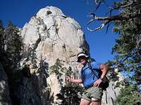
No doubt about the changing growth zones; these giants were everywhere after 6 hours on the trail.![Mt. San Jacinto]() Brent with Coffman's Crag looming behind.
Brent with Coffman's Crag looming behind.![Mt. San Jacinto]() It was often easy to lose the trail below the Long Valley entrance saddle.
It was often easy to lose the trail below the Long Valley entrance saddle.![Mt. San Jacinto]() Upon seeing this sign we had to holster our firearms!
Upon seeing this sign we had to holster our firearms!
The trail became steep and occasionally difficult to follow as it took switchbacks over large rocks and ungainly boulders. At 10:47 I took a picture of Brent with Coffman’s Crag behind him as though bestowing a silent blessing on our presence. Three minutes before eleven o’clock I veered slightly off trail to get a close-up picture of the State Game Refuge sign which had been unceremoniously nailed to the trunk of a towering pine tree. The bottom line of the sign offered that it had been posted with federal aid funds. What on earth could that possibly mean? It remains an enigma, but I suspect it means that a small portion of my income taxes had been used to tack it up.
Intermediate Goal Attained: About 10 minutes later, at 11:10 a.m., we burst upon and through a saddle and found ourselves gazing at level terrain. It was the terminus of Long Valley, and it wasn’t more than a minute until we began seeing several couples ambling along obvious pathways leading from the Mountain Station. Our spirits received this sight with elation as though someone had injected us with adrenaline.
We picked up our pace, found the bottom of the concrete walkway snaking down from the tram station structure and immediately decided NOT to walk up to the building itself. Don’t need more elevation right now! We stopped only to look at the map and gain our bearings in this forested landscape which offered such a rich and distinct contrast to the barren and steep ways over which we had come during the last seven plus hours.
![Mt. San Jacinto]() The park service map at the base of the concrete walkway leading to/from the tram Mountain Station.
The park service map at the base of the concrete walkway leading to/from the tram Mountain Station.![Mt. San Jacinto]() The self-issue wilderness permits are directly below the "Closed" sign.
The self-issue wilderness permits are directly below the "Closed" sign.: The Ranger Station was officially “closed,” but instructions regarding day-use permits were plain and the blue sheets were there along with a working ball-point pen. We complied with the requests, and made good use of the fancy restroom. I say fancy because there was a real-live flush toilet, and the small room also had a wall-mounted electric heater positioned near the commode. My GPS said the elevation here at the Ranger Station was 8,317’, but Brent said that an “official” sign had said 8,400’. My GPS was close enough for government work, I figured.
![Mt. San Jacinto]() Plenty of signs along the route to the summit. This one is a few meters beyond the Ranger Station.
Plenty of signs along the route to the summit. This one is a few meters beyond the Ranger Station.![Mt. San Jacinto]() This sign is 5 minutes beyond the Station, but the guy probably will not be there.
This sign is 5 minutes beyond the Station, but the guy probably will not be there.
So there we were, at the seven-hour point, we had climbed almost 8,000’ and we still had another 2,400’+ to go and 5.5 miles ahead of us. Since our goal was to be at the summit in ten hours or less, we felt a burst of confidence course through us which said, “Yes, guys, you should be able to do it!”
![Mt. San Jacinto]() Outhouse architecture with ditto marks. Water is just beyond these twin beauties.
Outhouse architecture with ditto marks. Water is just beyond these twin beauties.
From here on there were signs aplenty, sometimes a tad confusing but never incoherent or bewitching. For the next hour the trail was very easy to follow and had a gradual incline which would not have been daunting to even the most unfit hiker. Shortly before the eight-hour point we passed by what I call the “twin outhouses.” A hundred feet away we spotted several cabins, obvious accoutrements of the Round Valley Campsite area, and a pipe with cold, clear potable water flowing. This was like icing on the cake, and we both took a refreshing drink and directed some of this nectar into Brent’s Camelback bladder and my water bottle. Life is good!
![Mt. San Jacinto]() Ah, cool running drinkable water. A welcome surprise for us.
Ah, cool running drinkable water. A welcome surprise for us.
GPS elevation was a tad over 9,000’, our spirits were uplifted by the fresh water and we rejoiced that the remaining distance to the peak was a mere 3.3 miles. Using our grade-school mathematics skills we figured about 600 feet per mile to the top, on average. Yeah! We were so pumped that we gained 1,000’ in the next hour (1:30 p.m.), and we celebrated briefly as I took Brent’s picture next to a gnarled tree stump which was one example of many such silent sentinels along this upper trail.
Forty minutes later we were at the picturesque stone-walled summit shelter, a small building not really at the summit.
![Mt. San Jacinto]() The so-called summit shelter is .3 of a mile below the summit. Get ready for a mild scramble.
The so-called summit shelter is .3 of a mile below the summit. Get ready for a mild scramble. A hiker returning from the top told us that the route from the shelter was just a rock scramble .3 of a mile further and about 300’ of vertical gain. Piece of cake, man! The sign near the shelter was at an elevation of approximately 10,550’. It took 5 minutes from the shelter to the summit, and I felt such a surge of excitement as I saw the summit sign and several others that I could scarcely constrain myself from shouting to the heavens.
![Mt. San Jacinto]() This looks just like the summit! Hip-hip-hooray!
This looks just like the summit! Hip-hip-hooray!![Mt. San Jacinto]() The benchmark. There are at least 2 reference markers.
The benchmark. There are at least 2 reference markers.Assault Complete - A Summit Subdued
I expressed my jubilation through a broad smile “you could see a mile” to quote from the Bard of the Yukon, Robert Service. Brent arrived just a minute or two after I did and we talked with the hikers already there, two of them a couple from San Diego but originally from Poland. One thing led to another and they offered us a ride from the base of the tram to our car at the museum, so we received an extra dose of jubilation at the summit, knowing that we would not have to grovel for a ride down upon reaching the Valley Station.
The day was, in a word, gorgeous. We had reached the summit in nine hours and forty-four minutes, ahead of our planned arrival time, we were not injured or famished or bonking. We were both admitting just a hint of fatigue, but it was relegated to the second tier of worries, overcome by our excitement of success. Blue skies smiled on us; light winds gently cooled us and the views were worth thousands of accolades and superlatives. But we knew we had to get going; the approaching sunset would wait for no man, and we needed to be down to the tram before dark and at the same time as the generous couple who had offered us that very important ride back to our car. Without the ride we would be walking over six miles along pavement, and the thought of doing that was more than unsettling.
![Mt. San Jacinto]() If you take the tram up, you spot this sign leaving the Mountain Station.
If you take the tram up, you spot this sign leaving the Mountain Station.![Mt. San Jacinto]() One of the pages from the Aerial Tram brochure. Check out www.pstramway.com for more information. :)
One of the pages from the Aerial Tram brochure. Check out www.pstramway.com for more information. :)Mopping Up and Heading Out
Our departure from the summit was unceremonious to say the least. “Get going” and “keep moving” were our mottos and we deviated from that only to take one quick picture at the shelter. Consequently we arrived at the Ranger Station exactly two hours after saying goodbye to the granite summit boulders. We made no stops en route. Even though I was tired I felt like I was gliding as I motored robot-like up the serpentine concrete walkway leading to the Mountain Station. I had no sooner purchased a pair of one-way tickets down ($24 USD) than an announcement came over the PA system: The tram will go down in five minutes; please gather at the appropriate spot for your departure.
So we took the five o’clock tram down the steep cables suspending us above the darkening chasm of Chino Canyon. From 8,500’ to 2,600’ takes a mere ten minutes in the tram car, a car which rotates inside twice en route. Occupancy capacity is 80 people. But we had perhaps 35 sets of lungs oohing and aahing as we traveled down to the docking bay at the Valley Station.
Eric, our soon-to-be chauffeur, and his companion led us to their waiting BMW and in no time we had navigated the serpentine Tramway Road and were stopping next to our car in front of the Palm Springs Art Museum, the temperature warmer than any we had experienced the entire day. To say that we were excited is to understate our sky-high mood by a country mile. The remainder of this night and the next day were all according to schedule.
Day Number Three: When we pulled into our neighborhood at 7:30 Thursday evening we just looked at one another incredulously, shook hands and asked rhetorically, “So, when is our next adventure?"


Comments
Post a Comment