Finally!
![Cherry Peak]() Cherry Peak
Cherry PeakEver since I was little I can remember looking up at Cherry Creek Peak from Richmond, Utah and wishing I could stand on top of it. At first I was too young to climb it by myself and then I became too busy. After serving a 2 year LDS mission to the Philippines I was ready to get back onto a mountian after having been so far away from any mountains. I'm working 2 jobs right now so time is scarce but I finally had a day off on the 4th of July and I set my sights on Cherry Creek Peak. My Dad was also off work so we planned this trip together. The one thing we feared though on this trip was the heat as the week of the 4th was the hottest week of the year so far with temperatures in the 100's!
The route we planned to take was up the High Creek trail. We wanted to hike to High Creek Lake and the climb the East ridge and up to the summit from the lake. Even though this is the longest approah it is still probably the most fun.....at least in my opinion!
Packing In (Mile 1 & 2)
We decided to make this a 2 day trip even though it can be done in one long day. We wanted to take our time and enjoy it. Usually I work til 9 PM but I managed to get off work early on the 3rd (about 7:30 PM. I work in Logan, Utah and my house is in Preston, Idaho where I planned to meet my Dad and drive to the High Creek trailhead, which sits at about 5800 feet, just south of the Idaho border. As we drove my Dad reminded me that it was this same weekend 3 years ago that we were backpacking in the Sawtooth Mountains of central Idaho. I didn't realize that until he mentioned it. That was the last major trip I had been on.
By the time we started up the trail it was about 9:30 and the sun had just set. We had planned to pack in, in the dark so we had our headlamps ready. Surprisingly we didn't need to use then for quite a while as is was still light enough that we could see the trail. The High Creek Lake Trail is a well used trail and the elevation gain is not fast at first so we were able to make good time. The one big advantage we found to hiking at night was that it was nice and cool once the sun had set and we didn't need to worry about the heat. We hiked til about 11:00 PM and decided to make camp just before the trail starts to really gain elevation after crossing High Creek for the last time. It was obviously dark so we didn't see much scenery but we got far enough that we were able get a good start the next day. We were both feeling good and ready for a good night's rest and what the next day would bring. We made camp in the dark and had a quick bite to eat while I fiddled around with my backpacking lantern that decided not to work. After that we turned in for the night. We covered about 2 miles this night.
The Ascent
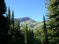
![Our First View of Cherry Peak]() Our first view
Our first viewWe woke up at about 7:00 AM the next morning. I didn't really sleep well as it was really my first night out after getting home from the Philippines. I wasn't used to it like I used to be. (It'll come back!) My Dad slept pretty well though. It was a beautiful morning and after a breakfast of oatmeal and hot chocolate it was even better. We decided to leave our tents, sleeping bags, and a few other things at camp to reduce weight on our climb.
Mile 3
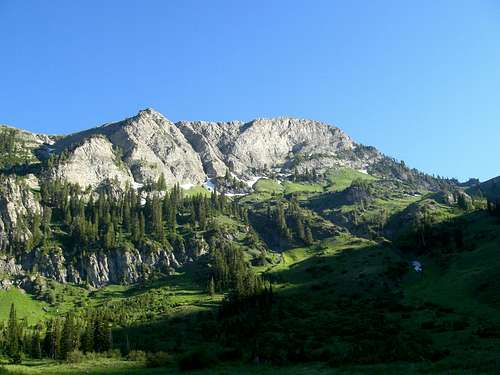
At about 8:30 we started up the trail. We were about 2 miles in from the trailhead and at this point the trail climbs above the river for quite a ways heading South toward an area known as the Beaver Dams, just below the North Face of Cherry Peak. The elevation gain on this part of the trail is moderate and the trail becomes more rocky. The nice thing is that it is in a forrested area so the trail is shaded and cool, especially in the morning as it is on the east side of the canyon. It takes the sun a little longer to reach it in the morning.
As we hiked up this section of the trail we were treated to some awesome views of the East side of Prater Moutain. Prater sits West of High Creek and forms the Western side of High Creek Canyon.
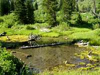
![Beaver Pond]() A Beaver Pond
A Beaver Pond
This section of the trail is about a mile long and is very pleasant. Near the top you are treated to your first view of the North face of Cherry Peak which will become more visible farther up the trail.
Mile 4
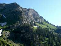
Once you reach the top of this pitch it levels off and enters the Beaver Dams, an area named for it's plentiful dams and ponds. Most of them are silted in now or are begining to be. It is appearant that this valley is glacial but the ice has long since disappeared. In this area there are hardly any large trees because of the many avalanches coming of the steep mountainsides on each side of the canyon. Most of the tall trees have been topple by these and so there are only small aspens ans a few subalpine firs. The most dominant feature of the Beaver Dams though is Cherry Peak's North face. It forms the Southern wall of the canyon and the top of it is about 700 vertical feet above the canyon floor. Even though it was a low snow year there was still a few places where the snow was piled up in the shadows and in the rocks. Prater Mountain is still to the west and has turned into a giant rocky ridge by now with at least 2 small waterfalls spilling through the rocks from springs up higher on the mountain.
![Closer to the North Face]() The North Face of Cherry Peak
The North Face of Cherry Peak About here is where it started to get hot. We were in the trees before but up here there weren't many as I said before. It was about 10:00 in the morning by now and the sun was pretty much overhead by this time.
At the southern end of the Beaver Dams there is neat little waterfall where High Creek comes tumbling out of the upper reaches of the canyon right under Cherry Peak. It's probably 20 or 25 feet tall and is quite refreshing. This is where we stopped to fill up with water again and it was well worth it to feel the spray of the water on our hot faces. The water also tastes wonderful as there are many, many mountain springs that feed it at this point.
![High Creek Waterfall]() The Waterfall
The WaterfallMile 5 to the Summit
The waterfall marks the beginning of the last mile to the lake and it sits just about 7,600 ft. This is the most difficult mile of the High Creek Lake trail as it really starts to gain elevation here. The lake is at 8,762 ft and so the trail gains about 1000 feet in a mile. The canyon turns to the east and enter a hanging U-shaped glacial valley that contains the lake. The trail takes you over 2 large cliffs and the lake is situated just behind the second one. A giant cliff wall is the backdrop of the lake and just over the top of it is Naomi Peak, the high point of the Bear River Range. This section of the trail is quite steep and has many switchbacks. There are a very large amout of wildflowers along this section of the trail in the meadows. It was funny that they were also conveniently red, white, and blue for the 4th of July!
We reached the lake at about noon and decided to stop for a lunch of dehydrated beef stroganoff and Powerade. There were a few other people at the lake with us but over all it was quiet and peaceful. It was still pretty hot though. I was pretty anxious to get to the top as I was within a mile (and 1,000 vertical ft.) of it. My Dad decided thaqt making it to the lake was good enough and opted to stay there and enyoy it while I climbed to the top. We turned on our radios and off I went up the trail. From the lake the trail goes to the pass between the top of High Creek and Smithfield Canyon. There is also a junction of trails at the top. The High Creek trail meets the Cherry Creek trail and the Tony Grove trail coming down from Mt. Naomi. To climb Cherry Peak it is possible to follow the Cherry Creek trail west towards the Soutwest ridge of the mountain and get on the summit from there. I opted to get off the trail here and bushwhack/scramble up the East ridge. There are very few trees up here and none right up near Cherry Peak so the heat was pretty oppressive at this point!
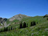
![Cherry Peak from the South]() Cherry Peak from the Junction
Cherry Peak from the Junction From the trail junction I found my way up to point 9346 and followed the ridge to the top. I was careful to stay just below the ridge on the South as to avoid some nasty exposure on the vertical North face. If you go too far to the North you'll fall and not stop until you hit the botton. Any approach from the North would be a technical class 5+ climb. This climb is a difficult class 2 and as you get nearer to the top from this direction it starts to border on a class 3 climb. I needed to use my hands to climb in a few rocky section and the pitch was quite steep. The rock is fairly loose and sharp but the sharpness also works to you advantage. Your boots will stick like glue to the rough rock! Your hands may get a bit torn up though.
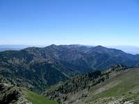
![Southern Mt. Naomi Wilderness]() Mt. Elmer, Jardine, and Flattop
Mt. Elmer, Jardine, and FlattopThe Top
I finally made it to the top at about 2:30 in the afternoon after about an hour of tough climbing. The view from the top is spectacular in all directions and you can see every major peak in the Bear River Range. The view of Mt. Naomi is about as good as any you can find because it is directly to the East. To the South Flattop, Mt. Elmer, Mt. Jardine, and even Mt. Logan are visible. To the North I could see Doubletop, Bullen Hole, Steam Mill, Magog, Prater, and many of the Idaho peaks. The one really negative thing though was that about every rock on the top was spray painted by everyone and their dogs, including scout troops! (Troop 54 in 1960 to be exact)There were also an insane amount of bees buzzing around at the top but other than those two things it was well worth the effort to get there. Looking down from the top into the Beaver Dams of High Creek was quite humbling as well.
![The East Ridge]() The East Ridge
The East RidgeThe Descent
![From the East]() East of Cherry Peak.
East of Cherry Peak.![A Long Way Down]() Off the North Face
Off the North FaceAt about 3:30 PM I decided that it was about time to head down. It was really hot and we still had to pack all the way out and break camp. By this time my Dad had decided to hike up to the pass where I left the trail and was waiting for me there. It took me about 45 minutes to get down because of the steep, rocky terrain. I was able to get a few more pictures of the North face and the surrounding mountains. I met my Dad down at the pass, where we ate some granola bars and got ready for the descent. By this time the sun was shining directly on us and it was miserably hot. After our short break we were able to get back down to the lake pretty quick but after that the going was pretty slow. We were both pretty tired from climbing all day and so the trip down was not so enjoyable. The footing is loose and rocky on the trail and we were tired so we took a few unintentional spills into the dirt as well. It took us about and hour to make it back down to the waterfall where we refilled with water for the rest of the trip. There we rested up and we started back on our way. The sun was beginning to get low in the sky but it hadn't cooled down at all. The only relief came when it finally dipped behing Prater Mountain and we walked into the mountain's shadow. It sure felt wonderful too!
As we made our way down the trail I kept looking over my shoulder at the mountain I had just climbed. It glowed brighter and brighter as the sun set and I wished that I could still be on top of it. My legs were making me wish that i was just at home in my bed though. My legs won the battle and I turned away and just kept hoping that our camp would be around the next bend.
From the Beaver Dams it took us about 2 hours to get back to where we had camped. By the time we got there we both wished that we could have stayed another night and not have to pack out the rest of the way. Luck was not on our side though and we broke camp. The extra weight didn't really feel that great and we were tired already so the going was even slower from this point on. It seemed like forever until we finally made it to the trailhead where our truck was parked! We were lucky that it was light enough that we didn't have to use our headlamps the entire way! We made it back at about 10:00 PM. after having left the top at 3:00 PM and it was just in time to hear the fireworks down in the valley from the 4th of July celebrations.
Needless to say It felt SO good to get home and take a shower and go to bed. I slept like a log that night of course! Cherry Peak was a great way to celebrate the 4th, probably one of the most fun ones I've ever had!
![Low Light on Cherry Peak]() Evening on Cherry Peak
Evening on Cherry Peak
Comments
No comments posted yet.