
-
 13483 Hits
-
 88.6% Score
-
 27 Votes
|
|
Mountain/Rock |
|---|---|
|
|
34.22241°N / 118.1112°W |
|
|
Los Angeles |
|
|
Hiking |
|
|
Spring, Summer, Fall, Winter |
|
|
4714 ft / 1437 m |
|
|
Overview: Unaffiliated and Misplaced
You will not find this little peak designated as “Inspiration Peak” on any map. Nor will you find it on the Sierra Club’s Lower Peaks List for southern California mountains under 5,000 feet. It is a mere 26 feet higher than its close neighbor, Muir Peak, also known as Mount Muir. To add some confusion to the mix, the 1995 Mt. Wilson 7.5 quadrangle designates this peak as “Muir Peak.” But by common convention and understanding, what is known as Muir Peak (or Mount Muir) is a peak with an elevation of 4,688 feet lying southeast of Inspiration Peak. However, our peak is aptly named. For one thing, it is virtually a stone’s throw from the well-known lookout structure, complete with sighting tubes, at the head of Castle Canyon, known as Inspiration Point.
 Sighting tubes at Inspiration Point
 The ramada/lookout at Inspiration Point
 Inspiration Peak from near Inspiration Point lookout
In the second place, the views from this peak can be inspirational. To the west, when it is clear, the ocean and Catalina Island rest in the distance. Points of interest to be seen in between include the downtown Los Angeles skyline, Griffith Park and the Verdugo Mountains. Mt. Wilson and Mt. Harvard are to the east and beautiful Castle Canyon is just south of you.
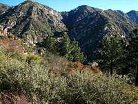
 Looking down Castle Canyon from near Inspiration Point 2/3/07
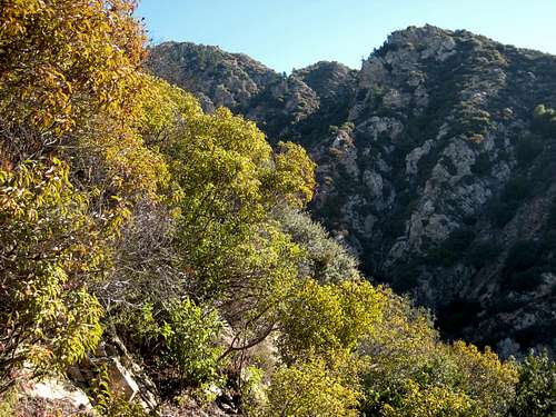
 Looking up Castle Canyon (C) to Inspiration Point from Echo Mtn. 2/3/07
Recommended Route The recommended route is to start at the trailhead for the Lower Sam Merrill Trail at the top of Lake Avenue in Pasadena. This trail initially crosses Las Flores Canyon and then winds up the east side of that canyon for about 2.5 miles to Echo Mountain. From Echo Mountain, take the steep Castle Canyon Trail up the rugged and awesome Castle Canyon 2 miles to the ramada/lookout at Inspiration Point.
 Inspiration Point ramada from Castle canyon Trail 2/3/07
 Looking at Castle Canyon from trail 2/3/07
From Inspiration Point, the peak is northwest about ¼ of a mile up a firebreak. The round trip for this route is about 10 miles with 2,900 feet of gain. Other Routes Alternative routes include (1) coming from the north on trail or fire road from the Mt. Lowe area; (2) coming from the southeast on the Idlehour Trail from the Mt. Wilson Toll Road; or (3) coming from the west on the Sunset Ridge-Mt. Lowe Fire Road.
Getting There
From the 210 Freeway, take the Lake Avenue exit in Pasadena and go north to the end of Lake Avenue, a distance of about 4 miles. The trailhead is on your right at the top of Lake, marked by a sign. You can park along either side of Lake Ave., or along Alta Loma Drive, which street runs perpendicular into Lake Ave. right at the trailhead. Walk past a stone pillar east on a path alongside a fence. In a couple of hundred yards you will come to another trail sign for Echo Mountain. Drop down onto the trail next to this sign and you will soon cross Las Flores Canyon and begin the ascent to Echo Mountain.
 Beginning of Lower Sam Merrill Trail
 Where Merrill trail crosses Las Flores Canyon at beginning of route
Red Tape
If you hike the recommended route from the trailhead at the top of Lake Avenue in Pasadena you will not need an Adventure Pass for your vehicle because the trailhead is not within the Angeles National Forest. For the alternate routes mentioned above, an Adventure Pass will be required to park your vehicle at the trailheads with one exception: if you start your hike at the Eaton Canyon Nature Center which provides access to the Mt. Wilson Toll Road and Idlehour Trail, you will not need an Adventure Pass. Adventure Passes ($5 per day or $30 for a yearly pass) can be purchased at many ranger stations within the Angeles National Forest and at most southern California sporting goods stores. No permits are needed for hiking any of the routes to this peak.
Camping
The Mt. Lowe Campground, less than a mile away, is the closest camping site to this peak. The Idlehour Campground is over 3 miles away southeast along the Idlehour Trail.
When to Climb
Year round. Even in winter, snow is a relatively rare visitor at this elevation.
Other Information
There are no water sources on the section of the hike to Echo Mountain. Going up Castle Canyon Trail, there is some water usually available in the canyon creek, but you would certainly want to treat it. It is best to carry all the water you need inasmuch as the roundtrip on the recommended route is only approximately 10 miles. USGS Topos Mt. Wilson 7.5
BobD3 - Apr 13, 2014 1:33 pm - Hasn't voted
The MyTopolink is misplaced. Just fyi.
T. White - Jan 21, 2018 8:07 pm - Hasn't voted
Re: The MyTopoStill not fixed - almost four years later :(