
-
 13030 Hits
-
 89.39% Score
-
 29 Votes
|
|
Mountain/Rock |
|---|---|
|
|
34.34870°N / 118.2291°W |
|
|
Los Angeles |
|
|
Hiking |
|
|
Spring, Summer, Fall, Winter |
|
|
5635 ft / 1718 m |
|
|
Overview
Seen from afar, the red tint of a surface ore formation on the south face of this peak gives its identity away as an “Iron Mountain.” This one is the second highest in elevation of the three Iron Mountains in the San Gabriel range. Number one is Iron Mountain #1 aka Big Iron at 8,007 feet elevation in the Sheep Wilderness and Iron Mountain #3 is at 5,040 feet elevation near the Monte Cristo Campground.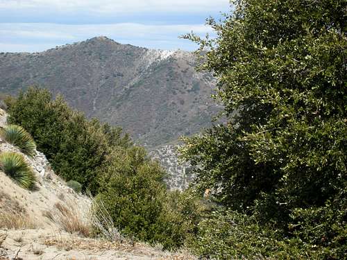 Iron Mtn. #2 seen from summit of Fox Peak aka Fox Mtn.#2, Feb. 10, 2007
Route 1: From Saddle East of Big Ben Saddle
The shortest route to Iron #2 is a Class 1 route of just a little over 6 miles round trip with 1,300 feet of gain. The starting point for this route is from a saddle at 5,700 feet, which saddle is about 1.5 miles east of Indian Ben Saddle. For a detailed description of this route see the Sierra Club’s Hundred Peaks Section's website for this mountain.
This peak can also be approached via the Trail Canyon Trail or via the Condor Peak Trail.
Route 2: Via Trail Canyon Trail
The Trail Canyon Trail takes you through a riparian habitat (read, lots of stream crossings) and in 5 miles meets the Condor Peak Trail between Iron #2 and Condor Peak.
 Looking up canyon along Trail Canyon Trail
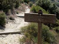 Junction Condor Peak and Trail Canyon Trails
You turn left here (northwest) passing a water tank and will now be on a dirt road. Keep following the road as it curves away from the peak and then goes back toward it. Eventually, you will come to a firebreak on your left. Leave the road for the fire break that in 0.8 miles and with 400’ of gain will get you to the summit. This route is a 14-15 mile round trip with 3,800 feet of gain.
Route 3: Via Condor Peak Trail
This trail starts out of Tujunga Canyon and climbs the south side of the mountain in a primarily chaparral habitat. Great views of Josephine Peak and Strawberry Peak open up to the east on this route. In about 6 miles you will reach a saddle just north of Fox Peak aka Fox Mountain #2.
 Looking at saddle between Condor Peak and Fox Peak (Fox Peak is at extreme right)
 Fox Peak aka Fox Mtn.#2 (5,033') with Strawberry Peak (6,164') to its left
 View from summit of Iron Mtn.#2
 Lenticular cloud formation seen from summit of Iron Mtn.#2
Getting There
Route 1: From Saddle East of Big Ben SaddleFor driving directions to the start of this route near Lightning Point Campground, see the
Sierra Club’s Hundred Peaks Section’s website for this mountain.
Route 2: Trail Canyon Trail
From Interstate 210, exit at Sunland Blvd. If driving west on 210, turn left onto Sunland; if coming from the east on 210, turn right onto Sunland. Go approximately one mile, within which Sunland becomes Foothill Blvd., to Oro Vista Avenue and turn left. In about a mile, Oro Vista enters Big Tujunga Canyon. In another mile, where Mt. Gleason Avenue intersects, Oro Vista becomes Big Tujunga Canyon Road. Drive about 5 miles on Big Tujunga Canyon Road to Upper Trail Canyon Road on the left. Turn left onto a dirt road (bumpy but easily passable by 2-wheel drive vehicles) and follow it about a mile to its end at a large trailhead parking area. From the parking area, hike past the trailhead sign onto Trail Canyon Trail. You will walk for a short distance on a dirt road and then reach the creek where the trail continues up canyon.
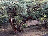 Manzanita tree near start of Trail Canyon Trail
Route 3: Condor Peak Trail
From Interstate 210, exit at Sunland Blvd. If driving west on 210, turn left onto Sunland; if coming from the east on 210, turn right onto Sunland. Go approximately one mile, within which Sunland becomes Foothill Blvd., to Oro Vista Avenue and turn left. In about a mile, Oro Vista enters Big Tujunga Canyon. In another mile, where Mt. Gleason Avenue intersects, Oro Vista becomes Big Tujunga Canyon Road.
You have two options for picking up the Condor Peak Trail. You can drive about 7 miles along Big Tujunga Canyon Road to a pull-out on the right just across from mile marker “4.50” (about 1/8 of a mile past Vogel Flats Road). The trail begins across the street right behind the mile marker sign.
Alternatively, you can continue a short distance on Big Tujunga Canyon Road to mile marker “5.82”. Park off the pavement. This is the beginning of the Condor Peak Trail. However, note that this option adds about 2 miles and 400 feet of gain to the round trip.
Red Tape
No permits are required for hiking any of the routes mentioned here or for camping. However, from any of the starting points/trailheads for these routes, your parked vehicle will need to display an Adventure Pass or Golden Eagle Pass. These passes are not sold in the vicinity of the trailheads mentioned here. You can purchase one ($5 per day or $30 for a yearly pass) at most southern California sporting goods stores.Camping
Tom Lucas Campground is 3.8 miles from the start of Trail Canyon Trail. Furthermore, there appear to be no restrictions on camping anywhere along the routes mentioned here. You should of course observe any fire restrictions as well as “leave no trace” principles.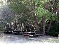 Tom Lucas Campground along Trail Canyon Trail
When to Climb/Mountain Conditons
This peak is accessible year round, except that you may encounter snow and/or icy conditions during the winter months and very hot conditions during the summer. Accordingly, come prepared with appropriate gear for the conditions. Generally, there is water in the creek along Trail Canyon Trail, but it must be treated. On the other routes, it is best to assume you will encounter no water sources.Check weather forecasts for the Mt. Wilson area to the southeast of Iron Mtn. #2 in local newspapers or internet weather sources. Conditions will be similar.
Other Information: Topos, Ticks and Poison Oak
The Trail Canyon Trail is heavily adorned with poison oak as it winds along the creek. Because poison oak grows mostly low to the ground (but not always), it is recommended that you wear long pants, at least until you are through the riparian part of the trail. There is much less of a problem with poison oak on the Condor Peak Trail where you might only encounter it at the few stream crossings.Particularly if hiking these routes during the spring, you should take precautions against ticks. Try to avoid brushing against the vegetation along the trail. Ticks will latch onto your clothing and skin. Check your clothing every once in a while or have your partner check you for any of these parasites you may have collected. Wearing light clothing helps in spotting them. Finally, your bag of skills should include learning how to remove a tick embedded in your skin. Lyme disease may be relatively rare, but there is no sense pretending there is no potential.
USGS Topos: Sunland 7.5 Condor Peak 7.5
External Links
Angeles National ForestSierra Club's Hundred Peaks Section's website for Iron Mtn. #2