
|
|
Route |
|---|---|
|
|
47.01020°N / 11.87390°E |
|
|
Hiking, Mountaineering |
|
|
Spring, Summer, Fall |
|
|
A long day |
|
|
Hiking; ferrata; F/F+ |
|
|
Overview
BREAKING NEWS: Mittwoch, 9.8.17
![Rotbachtal/Rio Rosso valley]()
Rotbachtal/Rio Rosso valley
Continuing on this side the trail n°23 connected with the trail (n°23a) coming from the village of San Giovanni/Sant Johann in Ahrntal. I remember, particularly during the long descent, the “mandatory” stop at the Rotbacher Alm/Maso Rio Rosso, where in front the view of the Valle Aurina/Ahrntal you could rest lying down on a incredible green and fresh meadow. This first part of the old route is usually described in the guides as the main option while the new one, described below, is considered even by recent book as an alternative. Today, the time needed to reach the refuge and then the summit is reduced because your starting point is higher. You can reach by car the Stalliler/Stallila hut at 1470 meters placed on the East side of the Rotbachltal/Rio Rosso valley and from here the signed trail to the Schwarzenstein/Sasso Nero starts .
The complete route gives the opportunity of seeing the typical environment of this area: woods, grass slope, moraine, rocks, glacier. It is also an interest mineralogical site and when no specific limitations were introduced, my father was able to find beautiful minerals (chlorite, quartz, granate).
Klettersteig durch Blitzeinschlag und
nachfolgendem Steinschlag
zerstört!!. Gletscherausrüstung empfohlen!
Zustieg zur Hütte: nur über den Gletscher!
Ferrata KAMIN destryed cause of lightening and stones falling down. The only acces to the refuge is by the glacier route!!!
The normal route to the Schwarzenstein / Sasso Nero runs both on the S-side of the Zillertal Alps / Alpi Aurine in the Italian territory, and on the Austrian N side of the boundary chain. It is a complete, easy and pleasant ascent assisted by the comfortable Schwarzenstein hutte / Rifugio Vittorio Veneto placed at about 2900 m, just below the glacier. In the past (about 25 years ago) the normal route started more than 500 meters below, directly from the village of Lutago/Luttach (about 960 meters). It followed the wood crossed by the stream Schwarzenbach/Rio Nero and entered in the West side of the wonderful Rotbachtal/Rio Rosso valley.

Rotbachtal/Rio Rosso valley
Continuing on this side the trail n°23 connected with the trail (n°23a) coming from the village of San Giovanni/Sant Johann in Ahrntal. I remember, particularly during the long descent, the “mandatory” stop at the Rotbacher Alm/Maso Rio Rosso, where in front the view of the Valle Aurina/Ahrntal you could rest lying down on a incredible green and fresh meadow. This first part of the old route is usually described in the guides as the main option while the new one, described below, is considered even by recent book as an alternative. Today, the time needed to reach the refuge and then the summit is reduced because your starting point is higher. You can reach by car the Stalliler/Stallila hut at 1470 meters placed on the East side of the Rotbachltal/Rio Rosso valley and from here the signed trail to the Schwarzenstein/Sasso Nero starts .
The complete route gives the opportunity of seeing the typical environment of this area: woods, grass slope, moraine, rocks, glacier. It is also an interest mineralogical site and when no specific limitations were introduced, my father was able to find beautiful minerals (chlorite, quartz, granate).
Although it must be considered always an alpinistic and quite long route, I suggest it to kids (from 9-10 y.o.). You can have the first experience with a safe “ferrata”, you may test ace-axe and crampons on the glacier, learning the progression on a easy glacier with low risks of crevasses (however visible). Moreover, if you are lucky and the sun is with you, all these experiences (exciting especially for a kid) may be lived in a wonderful scenery at 360°. A two (sunny-)days tour is recommended, but with a kid it is mandatory.
Approach
From Highway A22 (exit Bressanone-Fortezza/Brixen-Franzenfeste), take the road (S.S. 49) towards Val Pusteria-Brunico/Bruneck or, arriving from San Candido/Innichen, follow the S.S. 49 to Brunico/Bruneck. Follow the indication to Valle Aurina/Ahrntal, continuing up to Luttago/Luttach. Following the road S.S.621 running in the Ahrntal/Valle Aurina, overcome the indication of San Martino. A secondary roads turns left and by about four kilometres arrives at Stalliler/Stallila (1472 m).
- 1450 m from Stallila to the Schwarzentein/Vittorio Veneto refuge (4:40-5:10 h)
- 441 m from the refuge to the summit (1:30-2:00 h)
Descent:by the same route or by the Tribbachtal (1:00 to the refuge plus 3:00-3:45 to the start)
Stallila-Schwarzenstein/Vittorio Veneto refuge
Route Description
Ascent: 1891 m from the starting point to the summit- 1450 m from Stallila to the Schwarzentein/Vittorio Veneto refuge (4:40-5:10 h)
- 441 m from the refuge to the summit (1:30-2:00 h)
Descent:by the same route or by the Tribbachtal (1:00 to the refuge plus 3:00-3:45 to the start)
Stallila-Schwarzenstein/Vittorio Veneto refuge
Follow the trail to Daimerhuette/Malga Daimer (1872 m). Two years ago the old trail n° 23 was abandoned and a carriage road with the access limited to the owner of the Daimerhuette was built. In July 2007 the hut was also rebuilt maintaining partly the old structure and loosing some original characteristics of the inner space (0:40 h).
From Daimerhuette the path steepens within the Rotbach valley as it leads up to the moraine. A wonderful and refreshing well (“Quelle”) is encountered at about 2300 m. Stop there and fill your containers with the best water you know! At about 2500 m the path reaches the base of the residual Rotbachkees. When you get to the Stabeler Höhenweg (coming from the Chemnitzer Huette/Rifugio Giovanni Porro, about 5:00-6:00 hours), turn right and follow the sign “Kamin” (chimney), as the "ferrata" is named referring to its most interesting section. (2:45-3:00 h). ![In the middle part of the...]()
The "Kamin"
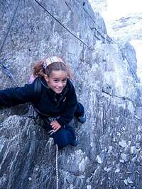
The "Kamin"
At about 2760 m the ferrata begins, recently rebuilt and now without any serious risk (no stones and very good wire rope). It runs into a groove, overcome a chimney and little ledges. After about 120 meters and 20 minutes more over blocks of stone you arrive at the Schwarzensteinhuette/Rifugio Vittorio Veneto (2922 m) (1:15-1:30 h).
If you would like to avoid the ferrata, you leave on you right the deviation to the “Kamin” and continue along the glacier route (Via del Ghiacciaio/Gletschersteig). The name, mainly in late summer, seems to be not more appropriate. The few patches of snow are disappeared and the glacier is only in my memory (and of all the climbers who visited the area just few years ago). This alternative from my point of view is less interesting and amusing. Few iron ropes and little ladders help the climbers.
Schwarzenstein/Vittorio Veneto refuge – Summit (Italian Normal route)
Schwarzenstein/Vittorio Veneto refuge – Summit (Italian Normal route)
From the refuge the route goes to N direction and by traces with few red or red/white indications ascend a first elevation, turns to left in the direction of an evident snowy ridge. ![Tribbachkees]()
Start from the refuge ![From the refuge]()
From the refuge

Start from the refuge

From the refuge
The route is generally well marked by traces in summer, but with fog or clouds you might loose the way. Ascend the ridge having on your left the SE side of the Schwarzenstein/Sasso Nero and your right the view of the Grosse Loeffler / Monte Lovello. In general you don’t need crampons, but pay attention in case of ice in late summer.
At the end of the ridge you have to climb a steeper slope with stones and rocky blocks (about 80 meters). By evident traces and helped by a rope (if you need) you get the Punta del Balzo/Felskopf (3235 m) (1:00-1:20 h).![Towards Punta del Balzo/Felskopf]()
Getting out to the Punta del Balzo<
At the end of the ridge you have to climb a steeper slope with stones and rocky blocks (about 80 meters). By evident traces and helped by a rope (if you need) you get the Punta del Balzo/Felskopf (3235 m) (1:00-1:20 h).

Getting out to the Punta del Balzo
Here you are on the boundary between Italy and Austria. ![Schwarzenstein glacier]()
The Schwarzensteinkees ![The Austrian side]()
Grosser Mochner The view open to the N side of the Zillertal alps with the wide Schwarzenteinkees and Floitenkees. The summit of Grosser Mochner (3283 m) appears, placed on the secondary chain, perpendicular to the main boundary’s chain, separating the Floitengrund (with the Greizer refuge, starting point to the Grosser Loeffler) and the Zemmgrund (with the Berliner refuge, Austrian starting point to the Schwarzenstein).
![Below the summit]()
50 meters below the summitTurn left descending few meters to the glacier and continuing easily in SW direction having on your left the ridge line. Usually in summer the route is well marked but pay attention in case of bad weather condition. By not more than 30 minutes you arrive at the base of the final elevation. By a steep but easy ascent following the SW ridge you get to the summit (cross) (0:30-0:40 h).
![Coming back to the refuge]()
Coming back
Descent
The same route till the refuge.

The Schwarzensteinkees

Grosser Mochner

50 meters below the summit

Coming back
Descent
The same route till the refuge.
Few years ago, with other glacier condition, the descent from the refuge by Via del Ghiacciaio/Gletschersteig should have been my advise. But today, especially in summer, the best option is the ferrata: fast and safe. From here take the trail of the ascent till the connection with the trail (n°19).
Two alternatives: i) the first one is to follow the same route of the ascent (trail n° 23), ii) the second is to take the trail n°19 towards the narrow saddle called Grosse Tor (2688 m), corresponding to the passage between the Rotbachtal/Rio Rosso valley (West) and the Tribbachtal/Rio Torbo Valley (East). This trail continues at first descending a steep slope (snow even in summer) and then more gently till the Kegelgasselalm hut (2123 m) placed on a natural balcony with the view of the Grosser Loeffler/Monte Lovello. Continue the descent and at about 1850 m leave the trail n° 19, directed the village of San Giovanni/Sant Johann, and follow the trail called Putzweg. The trail within the wood turns around the mountain and arrives to the Stallila hut. This second option is longer but it is ideal if you like to change the route of descent.
![on the summit of Schwarzenstein]()
To East ![Summit view]()
To West
- F. Cammelli, W. Beikircher, "Guida dei Monti d'Italia - Alpi Aurine, Brennero-Gran Pilastro-Vetta d'Italia", Ed. CAI-Touring Club Italiano, Milano, 2002 (ISBN 88-365-2603-9);
- L.A. Fincato, "Monti Rifugi Paesi delle Valli Aurina e Pusteria", Ed. DIP-Druck, Brunico (2000)
and one in German:
- "Zillertaler Alpen", Bergverlag Rother, Munich (1983)
Look at theweb-cam from the Schwarzensteinhuette/Vittorio Veneto refuge, active during the period of opening of the refuge.
Summit view

To East

To West
Essential Gear
Equipment for self assuring (ferrata-kit), harnesses, rope, crampons and ice-axe.Books and external link
Two books in Italian:- F. Cammelli, W. Beikircher, "Guida dei Monti d'Italia - Alpi Aurine, Brennero-Gran Pilastro-Vetta d'Italia", Ed. CAI-Touring Club Italiano, Milano, 2002 (ISBN 88-365-2603-9);
- L.A. Fincato, "Monti Rifugi Paesi delle Valli Aurina e Pusteria", Ed. DIP-Druck, Brunico (2000)
and one in German:
- "Zillertaler Alpen", Bergverlag Rother, Munich (1983)
Look at theweb-cam from the Schwarzensteinhuette/Vittorio Veneto refuge, active during the period of opening of the refuge.