Jaybird Peak
This was my 2nd peak of the day. I just finished hiking
Mt. Stirling.
Jim and I drove back down Road 552 from Stirling back onto 553. We then drove down 553 and then took the left turn for 553C. After 0.1 miles we turned right at the T-Intersection for 553A and continued for about 0.4 miles. We looked for a parking spot to pull off and not block the road. We finally found a spot to park without blocking the road to start for Jaybird. We finally found one about 0.18 miles SE of a rocky outcrop we could see on the ridge straight South of the Steep Cliff on the SW side of Jaybird.
Waypoints for the route
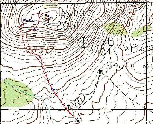
![GPS Trace of Jaybird]() GPS Trace
GPS Trace
WPT 1 36.49272 N 115.9455 W
WPT 2 36.4946 N 115.94736 W
WPT 3 36.4989 N 115.94933 W
WPT 4 36.49888 N 115.94897 W
WPT 5 36.4991 N 115.947764 W
WPT 6 36.499277 N 115.9480277 W
WPT 7 36.49833 N 115.948611 W
Descriptions
WPT 1 Park
WPT 2 Rocky Outcrop; go to the right side of this
WPT 3 Base of the main Rocky Outcrops below the ridge, and South of the main cliff
WPT 4 Gulley needed to gain the ridge
WPT 5 Summit
WPT 6 A gulley you can go down, not far past the summit on the way down, 1st gulley you see on your left when coming down from the summit.
WPT 7 Two little rocky outcrops here, go to the left side of the 1st one, then turn right 90 degrees and hike 40 yards or so then turn and go back down the scree.
![Jaybird Elevation Profile]() Elevation Profile
Elevation ProfileThe Hike
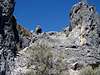
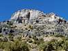
It started off nice along the ridge. After about .018 miles just past WPT 1, a rocky outcrop, we had about ½ mile of scree to hike up. This was painful. You could make switchbacks to make it easier. There are some class 3 sections as well. I had to use my hands and crawl in an offensive lineman’s stance several times because it was so steep. Near the top of the ridge below the cliffs we found a gulley to take up and then we were just below the summit. It was 0.76 miles to the summit with about 980 feet of elevation gain.
The Summit
We noticed the “Jaybird” Benchmark after we got onto the summit. This peak is not listed on the majority of maps and topographical software programs. There were some other USGS markers on the summit as well. I placed a summit log up there just next to the main USGS marker under some rocks.
Great views from Jaybird can be enjoyed. To the southeast are Wheeler Peak, Willow Peak and the Spring Mountains which you can see all the way up to Mt. Charleston and Lee Peak. TO the south is Mt. Stirling. The North provided good views of the Mercury military site at the edge of the Nevada Test Range. In the far distance one can make out Bald Mountain, about 13 miles North of Groom Lake and Area 51. The Sheep Range looked great to the East as well.
The Return Hike
On the way down we found a gulley to the North of the one we came up. This is WPT 6 on the list of waypoints, it's a short distance from the summit on your left side as you depart. We made it down this and then started to scree our way down the summit. After a certain point you reach a point on this ridge where there was 2 rocky outcrops. This is WPT 7. Go to the left of the first one rocky outcrop, then turn right and go about 40 yards to the next ridge. Now you can scree down this one. Eventually you make it to the first rocky outcrop that you passed by at the beginning of the hike, and now the screeing is done. It took us almost an hour to reach the summit but only 30 minutes to get back to the vehicle. This was a very rewarding peak after you reach the summit and is fun coming down.
Comments
No comments posted yet.