Synopsis
Amy and I enjoyed a fabulous hike and attained three ranked summits near Los Alamos, NM. We hiked from the
Pajarito Mountain parking lot to the summit of
Cerro Rubio (10449', ranked 148 in NM), then to the summit of
Shell Mountain (10510', ranked 140 in NM), then
UN 9870 (ranked 251 in NM), then back to the TH. The total roundtrip distance was ~10 miles with a total elevation climbed of ~2700'. It took us 5.5 hours. The weather looked a little iffy early in the morning (some rain in Los Alamos around 6am) but held up nicely for us during the hike. It was sunny in the morning, and then there was some cloud cover that was nice for the late morning and early afternoon. We only got a few drops of rain during the last mile back to the car.
Trailhead information & access issues
Please see the "Getting There" section of the
SP page for Pajarito Mountain. Park at the west end of the ski area parking lot and walk about 50 yards west along a dirt road and find the start of the
Guaje Canyon Trail (also known as the Cañada Bonita trail) heading right (NE) away from the ski area. This is the Guaje TH (~9200'). Most of the approach is on
Santa Fe National Forest land. However, the summits of Shell Mountain and Cerro Rubio are now located within the
Valles Caldera National Preserve, so please find out the latest access regulations before you go.
The hike to Cerro Rubio (10449')
We started hiking (~9200') along the Guaje Canyon Trail at 8:40am and quickly came to a fork in the trail in <10 minutes. The right fork is the main trail, and the left fork is the nordic ski trail. They both join together later on in the Cañada Bonita, a sloping meadow of native grasses. We took the left fork and before too long came upon the edge of the Cañada Bonita. We followed the trail, which hugs the southwestern edge of the meadow and climbs slowly toward a broad saddle. Before the saddle and just before a fence (now the boundary between the Valles Caldera National Preserve and the Santa Fe National Forest), the trail makes a hard right turn and continues NE, climbing back into the forest. After about 2.5 miles total, we reached the junction of the Guaje Canyon Trail with Pipeline Road, which goes E and SE down toward the town of Los Alamos. From the area around the junction, there are fabulous views toward the west down toward the Valle de los Posos.
![Cañada Bonita]() Cañada Bonita. Cañada Bonita. | ![viewpoint for Valle de los Posos]() View of Valles de los Posos. View of Valles de los Posos. |
We continued along the Guaje Canyon Trail through forest with occasional views of meadows and peaks to the west. About a mile past the Pipeline Road intersection, we started looking for a good spot to leave the trail and start heading NW toward Cerro Rubio. We were happy to see a cairn on a wood stump and a faint footpath heading up through grass! The GPS coordinates for this point are 35.9385°N/106.3952°W, and the altitude around 9620'. The footpath was extremely well cairned and we made good time climbing the SE slope of Cerro Rubio. Clearly, many people have been up this way and much effort was invested in putting up all the cairns. In fact, one of our friends in Los Alamos told us she has done some of the "cairn maintenance" on this footpath. Before long, about 100' below the summit, we came out on an old dirt road with a barbed wire fence (now the boundary between the Valles Caldera and Santa Fe National Forest). We looked around a bit but didn't see any more cairns, so we just kept heading uphill until reaching the flat summit plateau. We later found out that you can turn right at this road, and it will wind its way up to the summit. One thing about most Jemez peaks I've climbed: they're so flat and forested that you need to budget about 5-10 minutes walking around with your eye on the altimeter to make sure you hit the highest point. I think we found the summit where there was a pile of cairns. It was 10:40am, exactly 2 hours after we started hiking (about 4 miles from the TH).
![trail junction for Cerro Rubio]() Footpath leading away with cairns on a wood stump. Footpath leading away with cairns on a wood stump. | ![Amy on summit of Cerro Rubio]() Cerro Rubio summit shot. Cerro Rubio summit shot. |
On to Shell Mountain (10510')
There's another old road running right over the summit of Cerro Rubio. (I'm curious as to when these roads were used and for what.) We hiked down this road which meanders down to the 10050' saddle between Cerro Rubio and Shell Mountain, our next objective. We got a good view of Shell Mountain along the way. Shortly, we were at the saddle. We took a right too early, ending up a few hundred feet below the next road we wanted. See picture below for the correct beta. No problem, as we just bushwhacked up steep grass and found the road we wanted. We saw a no trespassing sign for the Santa Clara Pueblo at a switchback. Eventually, we had to leave the road again and bushwhack up steep grassy slopes and then forest until we reached the summit of Shell Mountain. It took only about 45 minutes from Cerro Rubio. The Shell Mtn summit was much better with a sheer drop-off to the NE and very nice views. We enjoyed a break and a cold pizza lunch there.
![Shell Mountain]() Shell Mountain. Shell Mountain. | ![saddle between Cerro Rubio and Shell Mtn]() Take the left fork, and then take the second road on the right. Take the left fork, and then take the second road on the right. | ![Santa Clara Pueblo sign]() No trespassing sign. No trespassing sign. |
![Amy climbing Shell Mtn]() Climbing steep grass. Climbing steep grass. |
![Chicoma Mtn from Shell Mtn]() Chicoma Mountain (11561'). Chicoma Mountain (11561'). | ![Cerro Toledo from Shell Mtn]() Cerro Toledo (10930') Cerro Toledo (10930') |
Then to UN 9870 and back to the TH
After our nice lunch break, we headed down, quickly found the old road and made it back to the saddle between Shell Mtn and Cerro Rubio. Surprisingly we saw another hiker as we headed up back toward Cerro Rubio. We chatted with him briefly and gave him some route beta for Shell Mtn. We did not have to reclimb Cerro Rubio, but rather contoured around its east side and descended slightly to the spot where the footpath had petered out earlier (old road and barbed wire fence). We quickly found the footpath and put away all our navigational tools and then set a fast pace back toward the Guaje Canyon Trail.
We got to the main trail and turned right and kept going. We scrambled out to a nice viewpoint just before reaching the intersection with Pipeline Road. From the intersection, it was a slight climb to a local trail highpoint (~9650'). We passed another party of hikers along the way. From the local highpoint (a little NW of UN 9870), we decided to leave the trail so we could get one more ranked summit (UN 9870). This wouldn't really add any more distance as we could descend the SW slopes of UN 9870 and pick up the trail at the edge of the Cañada Bonita. There was a very faint footpath heading SE toward UN 9870, which shortly led us into a large meadow. We walked in the meadow for awhile and then re-entered the forest, and did the typical hunting around for the true summit. There seemed to be several spots of equal height and we made sure to walk around all over the place. There was one high spot at the edge of an open area with a forest service sign asking people to stay off the grass below.
![Amy with UN 10250 behind]() Cool lookout point just off the main trail. Cool lookout point just off the main trail. |
![Meadows NW of UN 9870]() Meadow NW of the summit of UN 9870. Meadow NW of the summit of UN 9870. |
Anyway, we called it good and started down, following a shallow rocky gully (to avoid trampling the grass) down the SW slope of UN 9870. There was a nice view of both Pajarito Mtn and UN 10250 from here. Soon we picked up the trail. It started to rain lightly, but we made it back to the car soon after that (2:10pm), for a very enjoyable 5.5 hour three summit day! It was really nice avoiding our typical 600 mile RT weekend drive to CO!
![Pajarito Mtn & UN 10250]() Pajarito Mtn and UN 10250. Pajarito Mtn and UN 10250. |
![Cañada Bonita & UN 9870]() Cañada Bonita and UN 9870. Cañada Bonita and UN 9870. |
Recommended gear
Good hiking shoes & map/compass/GPS due to substantial off-trail terrain.
References and external links
1.
Lists of John
2. Craig Martin,
Los Alamos Trails (All Seasons Publishing, Los Alamos, 2006).
3. Pajarito Mountain
website
4.
Sky Terrain Trail Map for Santa Fe/Bandelier/Los Alamos (2006).
5.
Santa Fe National Forest
6.
Valles Caldera National Preserve
Comments
No comments posted yet.

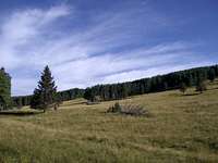 Cañada Bonita.
 View of Valles de los Posos.
 Footpath leading away with cairns on a wood stump.
 Cerro Rubio summit shot.
 Shell Mountain.
 Take the left fork, and then take the second road on the right.
 No trespassing sign.
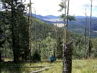 Climbing steep grass.
 Chicoma Mountain (11561').
 Cerro Toledo (10930')
 Cool lookout point just off the main trail.
 Meadow NW of the summit of UN 9870.
 Pajarito Mtn and UN 10250.
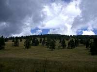 Cañada Bonita and UN 9870.