Synopsis
Amy and I took advantage of fresh snow, good weather, and visiting family (
i.e., free baby-sitters) to do a short ski tour and ski descents of
UN 9950 (NM rank #232) and
Rabbit Mountain (9938', unranked), which are in the
Jemez Mountains and the
Valles Caldera National Preserve (just west of Los Alamos, NM). From the
Coyote Call Trailhead (~8720'), we skinned up a road (buried deep in snow) toward UN 9950, then headed up steep trees to gain the ridge (Rabbit Ridge) just NE of the summit. After reaching the summit, we skied down to the saddle (9750') to the west and skinned up to Rabbit Mountain, where there were great 360 degree views. There's a nice NE facing open slope just below Rabbit's summit where we got some nice powder turns before entering dense trees and finally open flats. We reached the road (NM 4) just a short 5 minute hike from our car. Our tour involved ~1420' vertical climbed/skied, ~2.5 miles roundtrip, and it took us ~2.5 hours car-to-car. Thanks to
Jason Halladay for recent beta and also photos (
2/14/10 &
12/26/08) of this area that inspired us to go.
![Topo of Rabbit Mtn area]() Topo of the area showing the TH and summits.
Topo of the area showing the TH and summits.Climb to UN 9950 and Rabbit Mountain
We parked at a plowed space big enough for 2 cars at the Coyote Call Trailhead (on the south side of NM 4), which is located about 0.2 miles west of mile marker 41. It was overcast as we geared up and started skinning around 8:50AM. We followed the Coyote Call trail south and continued following a buried road to about 9100'. The road turned east and shortly thereafter we left it and headed up steeply through the trees. Just before getting to the ridge, it got quite steep, and it was quite a grunt with the foot or so of soft powder. We got to the summit of UN 9950 about 1.5 hours after leaving the car. It was nice and sunny by this point.
![Amy skinning with Rabbit Mtn in the background]() Amy skinning from the road. Amy skinning from the road. | ![Amy in the trees]() Amy skinning through deep powder in the trees. Amy skinning through deep powder in the trees. | ![View toward Chicoma Mtn from UN 9950]() View from the summit of UN 9950. View from the summit of UN 9950. |
Unlike most Jemez summits, the high point on this one was relatively obvious. From here, we skied down the ridge toward the 9750' saddle between UN 9950 and Rabbit Mtn. There was a nice open south facing slope that begged to be skied, but the snow was already baked from the sunshine the day before, so we continued up the ridge toward Rabbit Mtn, arriving just 20 minutes after departing UN 9950. It felt warm in the sun.
![Open slope south of Rabbit Mtn]() South slopes below Rabbit Mtn. South slopes below Rabbit Mtn. | ![Amy nearing the summit of Rabbit Mtn]() Amy just below Rabbit's summit. Amy just below Rabbit's summit. | ![Amy on the summit of Rabbit Mtn]() Amy on the summit of Rabbit Mtn. Amy on the summit of Rabbit Mtn. |
Ski descent
As opposed to the south facing slope, the snow on the NE facing slope was nice and soft. We peeled the skins off and started the ski descent around 10:50AM. The snow was fantastic, but the open slope was way too short. It got steep with a nasty-looking gully below, so we ducked east into the trees and enjoyed some more nice turns before things quickly got flat.
![Scott s first turns below Rabbit Mtn]() Scott's first turns below Rabbit Mtn. Scott's first turns below Rabbit Mtn. | ![Amy s turns below Rabbit Mtn]() Amy enjoying the powder. Amy enjoying the powder. | ![Amy on the flats]() Amy on the flats. Amy on the flats. |
We ended up at the road a short hike from the car. It was nice to see our tracks from the road.
![Amy hiking after a nice ski]() Hiking back to the car. Hiking back to the car. | ![Turns]() Our tracks. Our tracks. |
Links & references
1.
Lists of John
2.
Valles Caldera National Preserve
3. "
Santa Fe, Bandelier, Los Alamos," Sky Terrain Trail Maps (2006).
4.
Northern New Mexico Avalanche Exchange
Comments
No comments posted yet.


 Amy skinning from the road.
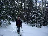 Amy skinning through deep powder in the trees.
 View from the summit of UN 9950.
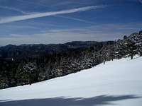 South slopes below Rabbit Mtn.
 Amy just below Rabbit's summit.
 Amy on the summit of Rabbit Mtn.
 Scott's first turns below Rabbit Mtn.
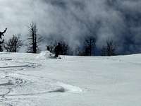 Amy enjoying the powder.
 Amy on the flats.
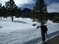 Hiking back to the car.
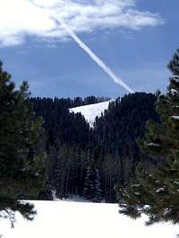 Our tracks.