-
 23800 Hits
-
 84.82% Score
-
 19 Votes
|
|
Mountain/Rock |
|---|---|
|
|
46.39835°N / 13.56482°E |
|
|
Mountaineering, Trad Climbing, Scrambling |
|
|
Summer, Fall |
|
|
6971 ft / 2125 m |
|
|
What's New On This Page?
General remark: (When reading Slovenian words on maps or in books, you will find special characters for ch, sh, and zh. They are written with c, s and z with a caron - little v above them.)
- JUL 17, 2020: Maps embedded.
- JAN 16, 2019: Design corrections, links to Peter Podgornik's page inserted - excellent climbing routes overview.
- JAN 24, 2005: Inserted links to the Kanin group. An overview picture linked.
- JUL 19, 2004: Initial setup of the page.
Overview
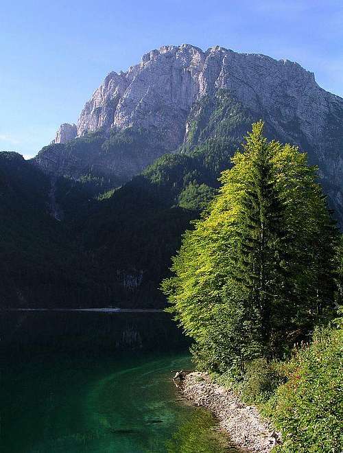 Jerebica / Cima del Lago from the Italian side
From the Italian side in last times the mountain is called also Cima del Lago - obviously very artificial.
The first tourist on Jerebica / Cima del Lago was O. Sendtner, on August 2nd, 1842.
 From Strmec (NE)
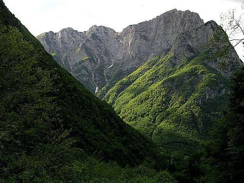
Although Kanin mountains are not the most appropriate for hard climbs, Jerebica is totally different. No scent of endless horizontal layers and ledges, but solid rock with vertical structures, dropping some 450 m and thus enabling attractive routes.
Not only climbers discovered Jerebica late, also ordinary mountaineers were neglecting this beautiful mountain. Some decades ago this was understandable, because the mountain lies on the Slovenian-Italian border. After regime became more liberal, the obstacle was remoteness and only one, although marked, quite long ordinary hiking route on each side of the border.
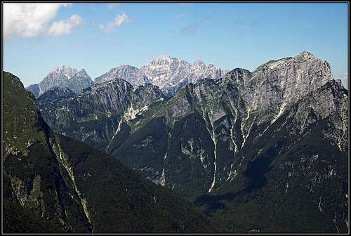
 From the W-NW
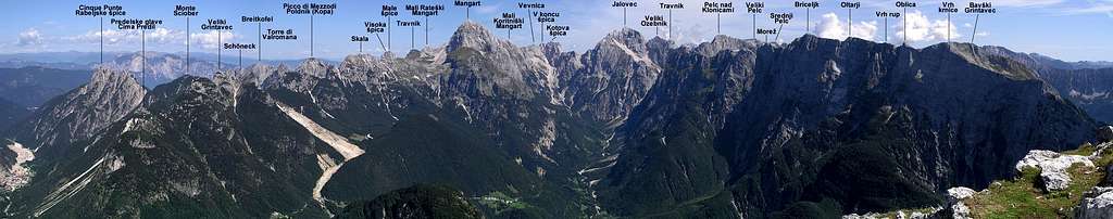
Jerebica stands in the main crest arriving from Kanin / Monte Canin (the dividing pass is Čez Brežič, 1699 m) towards the north-east, where on Predel Pass it reaches the Mangart-Jalovec group. Before reaching Jerebica and after leaving it, this crest has many lonesome peaks, which are only rarely reached by mountaineers. On the north-west, the slopes of this crest fall deeply in Jezerska dolina / Val Rio del Lago. On south and east, the slopes of Jerebica crest are falling first in Možnica valley (side valley of Koritnica) later in Koritnica valley itself. The crest ends on Predel Pass, 1156 m, where the road crosses the mountain range and border. In Jerebica subgroup the following peaks can be listed (from SW to NE): Bohinca, 1938 m, Mali Rukavec, 1728 m, Mesnovka, 1841 m, Veliki Snežni vrh, 1958 m, Gorenji Vogel, 1847 m, Krivi rob, 2005 m, Jerebica, 2125 m, Mala Jerebica, 1786 m, Planja, 1693 m, V podne, 1456 m, Nemške glave, 1596 m, Ruševa glava, 1512 m.
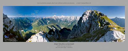
Summit Panorama
The panorama from Jerebica summit is great. The Mangart and Jalovec pair is from nowhere seen in such harmony, and rising above Log pod Mangartom more than 1900 meters! Towards the north-west the whole massif of Viš can be seen. Further to the south-west Kanin group, especially the high slopes of Rombon above Možnica valley are impressive. Towards the south-east in distance Krn group and on north-east the long, mighty wall of Loška stena.

|
 Kanin Kanin |
 Rabelj lake Rabelj lake |
Getting There
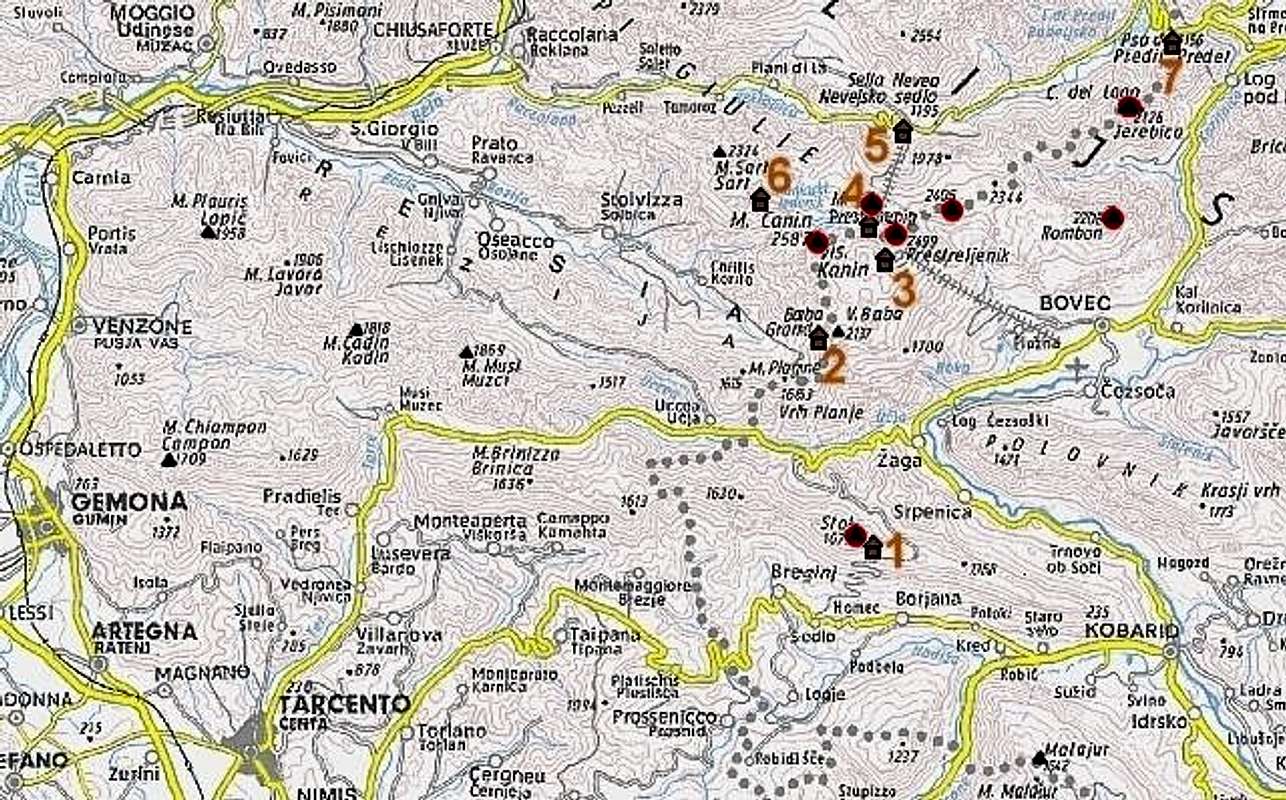 |
Numbers refer to Kanin group huts: (1) Koča na Stolu, See the Julian Alps overview page and the Kanin Group page! |
- By car/bus Soča valley and Bovec can be reached over Vršič pass (from Sava valley) or from the south, from Gorica / Gorizia. In Bovec you turn from Soča valley into Koritnica valley (towards the north, in the direction of Log pod Mangartom and Predel Pass). Arriving by car the true trailhead starts at the end of Možnica valley. Some 3 km south-west of Log pod Mangartom a narrow road deters towards the west and takes you into Možnica valley.
- Jezerska dolina / Val Rio del Lago can be reached from Trbiž / Tarvisio, driving southwards till Rabeljsko jezero (Lago del Predil, Lake Raibl).
Mountaineering Map: - Tabacco: Alpi Giulie Occidentali Tarvisiano (No.: 019). 1:25.000.
Julijske Alpe - Zahodni del (Western part). Planinska zveza Slovenije. 1:50.000.
Routes Overview
|
 Bor - Jerebica from the SW
Normal ascents
1. The southwestern ascent from Možnica valley can be treated as one of the two normal ascents. From the road end, up on Jezersko sedlo (saddle), 1720 m, and on the northern side of foresummits to the top. From Možnica valley 5 hours. Although marked, the route needs an experienced mountaineer.
2. From Jezerska dolina / Val Rio del Lago. In maps and in literature two approaches from north are mentioned. The first one starts in the main valley just opposite of Beli potok / Rio Bianco valley, then it ascends over the slopes of Mirnik, finally reaching Jezersko sedlo, 1720 m. This route is also marked and easier than the route from Možnica. The second route starts at Rabeljsko jezero (lake) and goes through Gamsov graben (Gola dei Camosci, Gamswurzgraben) - ravine, when reaching its end we need to scramble and climb a bit to reach the north ridge of Krivi rob and later the marked path. Would appreciate any further information about this route!
Waterfalls
Koritnica valley is also known as the valley of 100 waterfalls. Some of them are hardly accessible, others easily. Here are links to some waterfalls in the Jerebica area (also some English descriptions):
- Gorejca,
- Predilnica waterfalls,
- Ilovec,
- Waterfalls under Jerebica,
- Možnica.
![Moznica / Nemclja gorge]() Možnica gorge
Možnica gorge![Beech trees in Moznica]() Beech trees
Beech trees![Moznica/Nemclja waterfall]() Možnica waterfall
Možnica waterfallClimbing routes
This is the south face of Jerebica / Cima del Lago, and some of the routes in it. Source: Peter Podgornik: http://www.primorskestene.com/bavscica/greben-pihavcev-nad-bavsico/j-stena-jerebice. On this web page you can find topos for almost all routes. Routes:
This is the NE face of Jerebica / Cima del Lago, and some of the routes in it. Source: Peter Podgornik: http://www.primorskestene.com/kaninska-skupina/jerebica-2126-m/severozahodna-stena.On this web page you can find topos for almost all routes. Routes:
1. Kaminska (V-/IV)
2. Proletarska (VI-)
3. Smer samotnega gamsa (V)
4. Gruzijski steber (VI)
5. Sivi ideal (V+/A0)
6. Lubadarska (IV-V)
7. Steber žrebcev (VI)
8. Vaja con dios (VII/VI)
9. Centralna grapa (V)
10. Livada (V)
11. Tupilak (VI)
12. Čez plošče (III-IV)
13. Židovska poč (VI)
14. Steber ob centralni grapi (VI-/IV-V)
15. Bolero (VI+/V+)
16. Zapeljivka (V)
17. Steber svetega Martina (VII/V-VI)
18. Planika (VI-/IV-V)
19. Spominska (V/IV)
20. Steber ledig fantov (VI)
21. Ludra (VI)
22. Viharni steber (VI-)
23. Gradišarjeva grapa (45°)
24. Nevina smer (VI)
24a. Varianta Nevine smeri (V+/A2)1. Vzhodni raz (IV),
2. Smer ponočnjakov (V/IV),
3. Matijev steber (V/IV),
4. Smer izgubljenih idealov (VI/V),
4a. Vmesna varianta (Dušan Matelič in Miro Fon 16. 7. 1996),
5. Huljeva smer (VI/V),
5a. Direktna izstopna varianta Huljeve smeri (VI),
6. Alijeva smer (VI),
7. Metulj (VI/V),
8. Smer za izgubljene prijatelje (V+/IV-V),
9. Smer Gselman – Wagner (IV),
10. Tumova smer (IV/III),
11. Jadviga (VI-/IV-V)Red Tape
No limitations.When To Climb
Jerebica / Cima del Lago can be best climbed in summer and autum (not too late, when days become short!). The weather usually stabilises in Julian Alps in July.Camping
No mountain hut can help you to climb Jerebica / Cima del Lago. The mountain hut on Predel pass is useless for the ascent on Jerebica / Cima del Lago. In the end of Možnica valley nobody will chase you, if you set up a tent over the night. But camping for a longer period is not allowed. In Log pod Mangartom there are private tourist facilities, by Rabeljsko jezero (Lago del Predil / Lake Raibl) there is an official camping place.Mountain Conditions
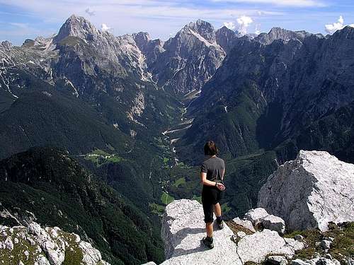
For weather see here.![Cima del Lago]() ClaudioNC - Summit view
ClaudioNC - Summit view