

-
 65930 Hits
-
 90.13% Score
-
 31 Votes
|
|
Area/Range |
|---|---|
|
|
48.09150°N / 113.9°W |
|
|
Hiking, Mountaineering |
|
|
Spring, Summer, Fall, Winter |
|
|
7542 ft / 2299 m |
|
|
Overview:
Layout designed for best viewing on a "1024 x 768" screen.
After standing on Mount Aeneas in the Jewel Basin in 1919, the Reverend Eugene Cosgrove would give a moving sermon on “The Secret of Wilderness” in Helena, Montana. He said.... “Hidden away by the Gods, like a necklace of pearls, among the crags and fastness of the [Swan] Mountains, lies the Jewel Basin, the enchanted land of this our Montana. Friends, I have seen the sun set on the minarets of Spain, and make splendid the dome of St. Sophia in Constantinople. I have watched the play of color upon the desert of Egypt, with the Sphinx and pyramids. I have made a trail through the hinterland of the Canadian Rockies, to where the Aurora Borealis from the polar skies make the northern night glorious … but for kaleidoscopic lights and shadows, for octaves of tone and color, for unending variety of the moods and forms of Nature, Jewel Basin is the most charmed and charming spot in all the world.” Source: Swan Journal article by Keith Hammer |
 |
|---|
Jewel Basin Hiking Area
Montana's Jewel Basin is located in Northwestern Montana. In addition to being designated a “Hiking Only” the Jewel Basin also offers above average Cutthroat Trout fishing and some incredible scrambles to its peaks. Mount Aeneas is the second highest and only peak that has a trail to the summit.
There are 5 named mountains in the Jewel Basin and 11 unnamed points that present enjoyable scrambles and incredible views in this area that has pockets of lakes that teem with fish.
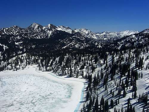
The Jewel Basin is located above the eastside of the Flathead Valley. Spectacular views are available to those who seek the higher country. One can also see into the southwest portions of Glacier National Park and the northern part of the Bob Marshal Wilderness.
There are 27 named lakes in the Jewel Basin and many of them have fish in them. This area is a popular area for hiking. It is not unusual to be sharing the trail with others but it is still possible to escape from the crowds. There are several campsites that are first come first served at selected lakes and most of them are an easy day hike away from the main trailhead at Camp Misery. The Jewel Basin contains 15,349 acres (62.1 km²) and 50 miles of trails. The Jewel Basin is specially designated for hiking only thus motorized vehicles and horses are prohibited.
Area History and Trivia:
According to Lake Shore Country Journal, the "Jewel Basin didn't become a non-motorized hiking area by accident. Cliff Merritt, now 88 and living near Hamilton, Montana, helped secure Congressional Wilderness protection for many areas in Montana in 1964, including the Bob Marshall Wilderness, and helped form the Montana Wilderness Association to advocate for more wilderness in Montana. He and many other Flathead Valley residents, like Loren Kreck, Jack Whitney and Elmer Sprunger, then worked on getting Jewel Basin designated Wilderness, accomplishing a first step by stopping motorcycles from trashing Jewel Basin's high alpine meadows via its designation as the Jewel Basin Hiking Area in 1970."
The locals say that Camp Misery was named for the place that a local tribe spent a terrible winter. It is not impossible to imagine such a winter as the snowfall in this particular area is measured in feet not inches.
Geographic Boundaries and Getting There:
 |
|---|
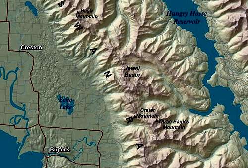
Map of Jewel Basin
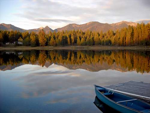
Fall Reflection
The Jewel Basin is located in the Swan Range of the Rocky Mountains in western Montana which runs north from near Seelye Lake, Montana and ends at the northern terminus at Columbia Mountain which is located near Columbia Falls, Montana.
It is located on the west side of Hungry Horse Reservoir and can be accessed from Hungry Horse, Montana via the Forest Service Road #885 which passes over Hungry Horse Dam.
The Jewel Basin is also located on the east side of the Flathead Valley which holds the beautiful Flathead Lake, the largest natural body of water west of the Mississippi River, it is also considered the gateway to Glacier National Park. The Flathead Valley also boasts 2 ski resorts and numerous golf courses for those who are inclined to play pasture pool.
When talking about the Flathead Valley the locals all say, "Have a nice VISIT in Montana". While you are visiting check out other things to do at Things To Do In The Flathead Valley.
Montana is a long way from most places. That’s why many of us live here.
It is possible to get here by:
By Air: Glacier International Airport serves as the air hub for northwestern Montana. Horizon, Delta Connection and Northwest Airlines service this area.
By Bus: Northwest Montana is served by bus service.
By Rail: Amtrak arrives daily from Minneapolis or Seattle stops in East Glacier, Essex, West Glacier and Whitefish.
By Road: The major highways serving northwest Montana include U.S. Highway 2 running east and west and running north to south are U. S. Highway 93 and Montana Highway 83. Glacier National Park is located 160 miles north of Interstate 90 which runs through the southwestern portion of Montana.
Rental cars can be secured in the Flathead Valley at and near Glacier International Airport. See Car Rentals in Montana.
Red Tape:
A permit is not needed to camp within The Jewel Basin. When choosing a campsite find one away from trails, meadows, lakes and streams to reduce your impact on fragile areas. “Leave No Trace” camping and hiking needs to be observed. Do not cut switchbacks and remember to “Pack It In - Pack It Out”
Campfires are permitted in the Jewel Basin but it is asked that you use a lightweight camp stove. No open campfires are allowed within 500 feet of Birch, Crater, Twin and Picnic Lakes, to prevent further damage around the lake shores.
There are pit toilets located at Camp Misery, Birch Lake and Crater Lake. The USFS requires that a cathole be used and be located at least 200 feet from water.
The Peaks:
Due to the nature of the geology there is little technical climbing available in the Jewel Basin. Most of these peaks are enjoyable scrambling to enjoyable ridge walks that lead to summits. Reaching those ridge walks can be a challenge unless good planning and route finding are used. There is a thick layer of brush blocking most of the trails which lead to frustrating bushwhacking approaches.
 Crater Mountain |
 Birch Peak Birch Peak |
 Squaw Ridge, Birch Peak and Mount Aeneas |
Many of the peaks are not named and we have designated these unnamed points to correspond with the lakes that they are near. This is merely a taxonomical method to help identify and clearly communicate with the reader regarding location and specifics related to the peaks.
</table >Hiking the Trails: 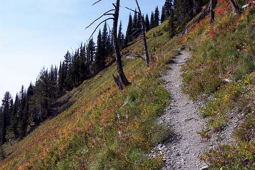
Alpine Trail #7With over 50 miles of established trails the Jewel Basin offers the opportuity to stretch your legs and reach a number of beautiful destinations. All of the trailheads are serviced by gravel roads that some would describe as poor at best. Plan on using a four wheel drive to arrive at your chosen trailhead. The National Forest Service has a cabin at the Camp Misery Trailhead that is usually staffed with helpful volunteers who will direct you the proper trail if asked. There is a 12 person limit for groups. The National Forest recommends groups that are 4 – 6 persons in group size for camping.Primary Trailheads for the Jewel Basin include:Camp MiseryGraves CreekStrawberry LakeWheeler CreekClayton CreekThe trails in the Jewel Basin are clearly marked and most a graded enabling most hikers to eventually make it to their destination. For those who are in good physical condition the trails will not present much of a challenge. Most junctions contain signs that mark both direction and distance to the next lake or junction. The Jewel Basin Map is also a useful reference for the trails and peaks.
Along the Ridges and On The Peaks: 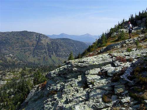
The Jewel Basin is made for Ridgewalks.Most of the peaks in the Jewel Basin are easy scrambles from the trails to their summits. Initial bushwhacking may be required before breaking out into the alpine areas of the Jewel Basin. Most of the peaks are within a short distance from the main trails that occur throughout the entire area. Please refer to the "The Peaks" section for specifics on each peak.Special Considerations:The rock in Northwestern Montana is widely varied and it is not unusual to find several different types of rock on any given route. Know your rocks and be certain of your safety. J. Gordon Edwards has an excellent section in his guidebook, A Climber's Guide To Glacier National Park, on rock and climbing safety. Be safe and know your limitations as well as those who are climbing with you. Also refer to the following links for further details: GNP Rock and Grading System and the GMS Climbing Guidelines.Fishing the Lakes:The Early History of Fishing in The Jewel Basin:Most of the lakes in the Jewel Basin were initially planted from horseback by Forest Service packers in the 1920s and 1930s. There was no understanding the differences between differing sub-species of trout. A cutthroat trout was considered a cutthroat. With the scientific advances fish biologists have identified many different subspecies of cutthroat trout. The Current Problem:In Northwestern Montana the Westslope Cutthroat Trout is the native fish and part of its home range has been threatened by planting other sub-species of cutthroat such as the Yellowstone Cutthroat, which is not a native to northwestern Montana. There are also strains of rainbow trout that where planted in the Jewel Basin as well. Rainbow trout are not natives of this area. These fish have hybridized with the pure Westslope and now their offspring threaten the South Fork's native population.The streams flowing east from lakes in the Jewel Basin are potential sources for hybrid trout in the mountain lakes to enter the South Fork water system which includes the river itself as well as Hungry Horse Reservoir. The South Fork is unique due to the Hungry Horse Dam blocking any non-native fish from entering the system. The South Fork empties the Bob Marshal Wilderness System and is teeming with wild catchable Westslope Cutthroat Trout and Bull Trout. See a picture of a 15 pound Bull Trout.The Planned Cure:The Montana Fish, Wildlife and Parks (MTFWP) has embarked on an ambitious and controversial plan to protect the South Fork of the Flathead River and keep the Westslope Cutthroat population pure. Long time users of the Jewel Basin, like my father-in-law, feel that they will never again experience the fishing they had back in the day as they feel it will take years for these lakes to become re-established. The MTFWP says not so and they are confident that fishing will be quickly resored. The next decade will show who was right. Here's to hope for the future!An excellent article covers some of the history of how trout were planted in Montana’s mountains as well as the rationale behind the WCTCP. This plan calls for treating up to 21 high mountain lakes spread over a 10-year period (about two lakes per year) in the late fall using rotenone, a fish toxicant, to remove hybrid fish. The hybrid fish will be removed so they won’t interbreed with Westslope cutthroat trout downstream in the South Fork of the Flathead River. The treated lakes will then be restocked the following spring with pure Westslope Cutthroat trout.
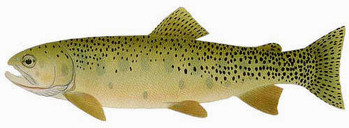
Westslope Cutthroat Trout
Fishing for the Westslope Cutthroat Trout:
The Cutthroat Trout is considered by many anglers as perhaps the easiest of all trout to catch. They are the trout that always look up. The fish in the Jewel Basin certainly represent their species well and readily rise to a well presented fly as well as hit on various presentations from spinning rods. An inflatable float tube will certainly increase an angler’s ability to fish more of the lake as most of the lakes are choked with brush along the edges.
Most of the fish in the Jewel are not overly large. Although there will be hang-overs from previous plantings in lakes that are not poisoned by the MTFWP plan that reach into the upper teens in length. One particular lake that I regularly fish yielded 10 fish all over 18 inches on 10 consecutive casts in years gone by (this lake is on the plan for rehabilitation) and there are certainly some larger fish to be had by a skilled angler.
Due to the Montana Department of Fish, Wildlife and Parks current management plan fishing in the Jewel Basin can be challenging. For further details on the see the Rehabilitation Schedule.
Link to this excellent article about Fishing Mountain Lakes by my friend, John Fraley, the Information Officer at the Kalispell office of MT FWP.
Suggested fly patterns include: mosquito patterns, ants, Gold-Ribbed Hare’s ear nymphs, Adams, Olive Wooly Worms and Damsel Fly patterns. Be prepared to fish both surface and subsurface on a 4 to 5 weight rod.
Suggested spinning lures include: Lures with the following colors: silver, bronze, red and white, orange and black.
Perhaps the most effective technique is to use a fly behind a float thrown from a spinning rod.
The Lakes:
Aeneas Lake
Located below Birch Lake and is barren. It is not deep enough to sustain life during the winters. Is not fed by Birch Lake. Recommended access Camp Misery Trailhead.
Big Hawk Lake, Upper and Lower
Big Hawk Lakes are located on the south end of The Jewel Basin. It was poisoned with Rotenone in September 2008 and was replanted in the summer of 2009. In the past the lake produced 15 inch trout, it may take a few years for the fish to reach this size again. Recommended access Wheeler Creek Trailhead.
Birch Lake
Birch Lake is perhaps the most used and fished lake in the Jewel Basin. It is a large lake and is over 100 feet deep. Trout can be seen rising along the shore lines at the transition between the shallows and the drop-offs. There are some large fish in this lake that are plenty difficult to catch. The small ones rise effectively to a well presneted fly and also will hit spinning lures with abandon. Planted by MTFWP with Westslope Cutthroat Trout on a yearly basis. This lake is a safe bet for fishing as it is not part of the MT FWP management plan. Recommended access Camp Misery Trailhead.
Black Lake
Black was poisoned with Rotenone on September 28, 2007 and was restocked summer of 2008 with catchable sized Westslope Cutthroat. Black Lake has campsites and a beautiful creek with waterfalls leading down to a lower unnamed lake. It is located below Picnic Lakes. MTFWP reports that the lake is healthy with sustainable populations of aquatic life and trout. Climb down beside the falls to catch the fish that escape down the creek. Recommended access Camp Misery Trailhead.
Blackfoot Lake
Blackfoot was poisoned with Rotenone on October 8, 2007 and was restocked summer of 2008 with catchable sized Westslope Cutthroat. MTFWP reports that the lake is healthy with sustainable populations of aquatic life and trout. Recommended access Camp Misery Trailhead.
| Summit Name | Elevation in Feet | Latitude | Longitude | ||
|---|---|---|---|---|---|
| Big Hawk Mountain | 7,542 | 48.09212 | -113.85422 | ||
| Mount Aeneas On SP | 7,508 | 48.14834 | -113.91962 | ||
| Three Eagles Mountain | 7,462 | 48.11215 | -113.87069 | ||
| Point 7300 (Cliff Lake Peak) | 7,300 | 48.15599 | -113.8994 | ||
| Point 7272 (Pilgrim Lakes Mountain) | 7,272 | 48.1037 | -113.86316 | ||
| Point 7268 (Southern Boundary Peak) | 7,268 | 48.08777 | -113.86942 | ||
| Point 7210 (Seven Acres Peak) | 7,210 | 48.14913 | -113.88735 | ||
| Point 7175 (Black Lake Peak) | 7,175 | 48.1591 | -113.90881 | ||
| Point 7164 (Twin Lakes Peak) | 7,164 | 48.17433 | -113.93875 | ||
| Point 7110 (Noisy Creek Peak) | 7110 | 48.18551 | -113.94758 | ||
| Point 6948 (Birch Peak) On SP | 6,948 | 48.1331 | -113.92193 | ||
| Tongue Mountain | 6,907 | 48.19671 | -113.92647 | ||
| Point 6888 (Wildcat Mountain) | 6,888 | 48.19431 | -113.9629 | ||
| Point 6850 (Squaw Ridge) On SP | 6,850 | 48.12441 | -113.91594 | ||
| Point 6805 (Clayton Mountain) | 6,805 | 48.20126 | -113.90093 | ||
| Crater Mountain On SP | 6,787 | 48.11592 | -113.9135 | ||
| Point 6677 (Wheeler Peak) | 6,677 | 48.07938 | -113.88426 | ||
| Trail No. | From/To | Total Distance (Mi.) | Elevation Gain (Ft.) | Elevation Loss (Ft.) | Difficulty Rating (Relative) |
| 717 & 7 | Camp Misery Trailhead to Birch Lake | 3.0 | 610 | -160 | Moderate |
| 8 / 68 & 7 / 392 | Camp Misery Trailhead to Picnic Lakes | 2.5 | 1778 | -588 | Strenuous |
| 8 & 721 | Camp Misery Trailhead to Twin Lakes | 2.5 | 770 | -200 | Moderate |
| 719 | Black Lake to Jewel Basin | 0.5 | 240 | -320 | Easy |
| 719 | Jewel Basin to Blackfoot Lake | 1.6 | 0 | -440 | Easy |
| 8 / 7 & 55 | Camp Misery Trailhead to Clayton Lake | 6.2 | 0 | -770 | Strenuous |
| 420 | Rd. 1633 to Clayton Lake | 2.3 | 1420 | 0 | Moderate |
| 717 | Camp Misery Trailhead to Mount Aeneas | 3.0 | 1778 | 0 | Strenuous |
| 717 | Mount Aeneas to Picnic Lakes | 1.2 | 0 | -888 | Moderate |
| 8/7 & 723 | Camp Misery Trailhead to Wildcat Lake | 4.3 | 850 | -360 | Moderate |
| 717 & 7 | Camp Misery Trailhead to Crater Lake | 5.3 | 610 | -560 | Moderate |
| 64 & 7 & 722 | Wheeler Creek Tailhead to Big Hawk Lakes | 5.6 | 1000 | -250 | Strenuous |
| 717 & 7 & 722 | Camp Miery Trailhead to Big Hawk Lakes | 9.0 | 610 | -838 | Strenuous |
 Fishing at Birch Lake |
 Squaw Lake |
 Martha Lake |
 Crater Lake |
 Outlet of Birch Lake |
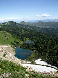 Picnic Lake from Mount Aeneas, Kowski photo |
Clayton Lake
Clayton is accessed from the west side of Hungry Horse Reservoir. This is an enjoyable hike along Clayton Creek. Early summer and late fall would be prime times to hit this lake. Clayton is scheduled for rehabilitation in 2014. Recommended access Clayton Lake Trailhead.
Cliff Lake
Another off trail bushwhack is required to make it to Cliff. Its name is appropriate as there is an awesome cliff near the inlet of this lake. Cliff is accessed from the Graves Creek drainage just above Handkerchief Lake. Fishing was good here when the writer fished it but things are always subject to change and flux. A game trail can be followed to this lake but it is difficult to find. Recommended access Graves Creek Trailhead.
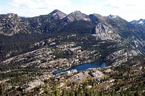
Crater Lake
This jewel is located about 2 miles south of Birch Lake on Alpine Trail #7. Crater presents a great opportunity for float tube fishing. Explore the lake and find the little bays that support a larger amount of aquatic life. Enjoy the incredible boulder field on the northwest side of the lake. Crater is also a safe bet for fishing as it is not scheduled for WCTCP program. Recommended access Camp Misery Trailhead.
Jewel Lakes
A string of beautiful lakes located between Black and Blackfoot Lakes. Most of the Jewel Lakes have fish. The shores have a lot of brush so a float tube may be helpful if there is aplan to fly fish these lakes. There are trails leading to most of the lakes. Recommended access Camp Misery Trailhead.
Martha Lake
Martha is an off trail lake with marginal fishing. More than likely the fish in Martha have slipped down Birch Creek and now make Martha their home. It is possible to see the rises of the trout from the Alpine Trail #7 above the lake. This lake will have fish as it is not part of the management plan. Martha is located far below the Alpine Trail # 7. There are also some incredible rocks for free climbing and/or scrambling on the south side of the lake. Recommended access Camp Misery Trailhead.
Picnic Lakes
Barren, located below Mount Aeneas accessed from Camp Misery Trailhead through Picnic Lakes Notch. A great place for a picnic thus the name. Recommended access Camp Misery Trailhead.
Pilgrim Lakes, Upper and Lower
Pilgrim Lakes are scheduled for rehabilitation in 2014. These are worthwhile lakes to fish on the southern end of the Jewel Basin. Perhaps the best approach is from Wheeler Creek on the Hungry Horse Reservoir side. This lake is about 30 acres in size and is quite deep. Recommended access Wheeler Creek Trailhead or a long trail from the westside after parking at the Camp Misery Trailhead.
Seven Acres Lake
Seven Acres is an off trail bushwhack to a small lake with questionable fishing. The guidebooks say it is planted with cutthroat but not too many people make it there. Located up the Graves Creek drainage from Handkerchief Lake on the west shore of Hungry Horse Reservoir. This writer has never been there and it certainly would require a large amount of dedication to get there. Recommended access Graves Creek Trailhead.
Squaw Lake
At one time this was a family favorite lake to fish. We don’t hear much about Squaw anymore. It is planted occasionally with cutthroats. Squaw is located about ¾ miles south of Birch Lake on Alpine Trail #7. Recommended access Camp Misery Trailhead.
Three Eagles Lakes, Upper and Lower
Three Eagles is scheduled for rehabilitation in 2009 and most likely will be planted in 2010. These lakes are a long way from Camp Misery but are easily accessed from the Hungry Horse Reservoir and Wheeler Creek. This is another lake that has great potential for anglers. Recommended access Wheeler Creek Trailhead.
Twin Lakes
These lakes are located just east of the Noisy Creek Notch. These lakes may be too shallow to support trout but the scenery is definitely worth the trip. Unless you need to practice your casting skip these lakes and head for Black, Clayton or Blackfoot where there is more aquatic life to support fish. Recommended access Camp Misery Trailhead.
Wildcat Lake
Wildcat will be rehabbed in 2009 and more than likely planted in 2010. Wildcat is 4.3 miles one-way from the Camp Misery trailhead and has an 850 feet elevation gain as well as a 360 feet elevation loss. Excellent fishing can be found but they are not as large as they once were. In the 1970’s Wildcat was legendary for the large trout that were found there. Not so many in this large size anymore but definitely a worthwhile trip. Check out the lake down stream from Wildcat as well. Recommended access Camp Misery or Strawberry Lake Trailhead.
Fish of the South Fork of the Flathead River:
Most of the lakes in the Jewel Basin serve as water sources for the South Fork of the Flathead River.
In addition to the West Slope Cutthroat Trout there are other species that share these waters.

Bull Trout - Salvelinus confluentus

Bull Trout
The primary predator in the South Fork is The Bull Trout. The Bull Trout in the photo is about 15 pounds and was 35 inches in length. The state record Bull Trout from Montana weighed 25.63 pounds and was 37 inches long.

Artic Grayling

Artic Grayling
The Grayling is perhaps western Montana's beautiful and unusual fish. The state record Grayling was caught in one of the South Fork's lakes not far from the Jewel Basin. They are not a difficult fish to catch. Generally they will hit black flies that are retrieved just below the water's surface. Generally these fish grow to near 20 inches in length.

Mountain Whitefish
Mountain Whitefish are also found in the river system. This is a great tasting fish if you can catch them. These fish are generally 10 to 16 inches in length and prefer rivers to lakes.

Northern Pike Minnow

Northern Pike Minnow
Easily caught while angling most Montana's think of this fish as a nusance and they are very effective predators of young fish.
Flora and Fauna:
The alpine meadows abound with wildflowers. Many of the same flowers found in Glacier National Park are also found in the Jewel Basin.

Huckleberries

Lewis Monkey Flower
 Alpine Forget-Me-Not
 Red Sedum |
 Low Larkspur |
 Tapered Leaved Beardtongue Tapered Leaved Beardtongue |
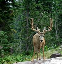
Mule Deer, echoguy photo.
The Jewel basin is home to most of Montana’s large mammals including elk, mule deer, shiras moose, mountain goats, grizzly bear, black bear and mountain lions.
The area is also frequented by smaller predators.
As with all hiking and climbing in Bear Country use caution and practice good manners with the wildlife.
You are in bear and mountain lion country. Carry bear deterrent spray, don’t hike alone and make some noise.
For more information please go to Glacier National Park's website for Bear Information.
The U.S. Forest Service also has helpful information on Grizzly Bear Management.
Seasons and Conditions:
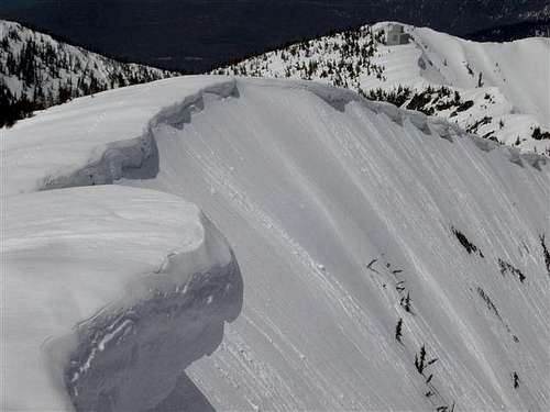
Winter in the Jewel Basin
Winter in the Jewel Basin
The Jewel Basin can be accessed throughout the year. It is most easily accessed towards the end of June on the west side and as early as May on the east side from Hungry Horse Reservoir. The Jewel Basin Trailheads can be accessed by vehicles until the roads are closed by snow. It can also be accessed via snowmobile in the winter, please remember that the Jewel Basin is CLOSED, therefore OFF LIMITS to motorized vehicles.
In recent years snowmobilers have illegally been entering the Jewel Basin and a few of them have been caught in avalanches. Backcountry skiers need to be familiar with snow travel and be prepared to deal with possible avalanche conditions.
It is possible to get turned around in the Jewel Basin. Carry a compass and map and leave a trip itinerary with contacts.
A GPS will also help if you are unsure about your routefinding abilities when traveling off trail.
For current Avalanche Advisory.
Newsworthy Events in the Jewel Basin
AVALANCHE
SNOWMOBILES
SKIERS
SEARCH FOR LOST HIKERS
2009 HIKER MAKES HIS WAY OUT OF WOODS SAFELY 
Resources and Links:
Map of the Jewel Basin
Flathead County Search and Rescue
USFS Official Jewel Basin Site
granite7 - Sep 6, 2019 6:20 pm - Hasn't voted
Wheeler Creek Trail approach and #7 conditionsMuch of the trail info is outdated and needs to be corrected. I went to this area to climb up Three Eagles Mountain via Wheeler Creek. The trail from the parking area which requires a stout vehicle preferably with all-wheel or 4wd is poorly maintained. The overgrowth for the first 2.7 miles of trail is 5 feet high and most of the time you can't see your own feet for all the brush. It easy to get off trail and end up at the wrong elevation. Lots of bear scat in this area too. Not recommended for children as they will be overwhelmed by the enormous amount of biting bugs, stinging nettles and tics. After reaching Trail # 7, the trail is better but still very overgrown with steep a drop-off to the west with poor footing. This trail is in need of repair and heavy maintenance if a viable attempt is to be made by the average hiker. For the determined it is a challenging bushwhack for many miles. We finally made it to Wildcat Lakes and then broke away from the so called trail and began route finding and scrambling up a steep gully to the north to reach a pass that overlooks Pilgrim Lakes. We then descended backdown steep terrain of rocks, small trees, and cliffy areas to reach upper Pilgrim Lake. From there it is short hike around the lake to reach another gully line that leads to another pass just west of Three Eagles Mtn. Gain the ridge and scramble another 1/2 hour or so to the summit. This entire trip out will take in the neighborhood of 10-12 hours round trip. Again this is not an easy hike as Flathead Native infers. It will take some effort to just reach the lakes before any scrambling begins. I would not consider this a climb per se or mountaineering of any kind. It is simply a grunt and a peak bagging at best. No gear or technical ability is required or involved. All you need is a stubborn determination and good weather to top out.