Approach
I was not planning on doing the climb until the next day, but the weather had other ideas. I had just driven up to my family's cabin, which sits about 8 miles north of the peak, the day before from Texas. I slept in and checked the weather after breakfast. I found that the weather was going to deteriorate by that evening. It was not gonna get bad, but 50s and sunny up high is much nicer than 40s and showers.
I packed up my daypack, and headed to the Alamitos Trailhead (take Forest Road 161 off of Highway 518) arriving at around 10am. The trail is very straightforward and the only factors that slowed me were not being in shape and the altitude (trailhead is 10,300ft-ish). The only notable thing that occurred was I saw a nice elk standing on the trail. I took a picture, but the elk is not visible in it. After about 4 miles, 1,800ft vertical and 2 hours I reached treeline at 12,000ft, I was feeling pretty good. From here the trail begins to switchback through the alpine willows up to the ridgetop.
![Serpent Lake]() View of Serpent Lake as you top treeline.
View of Serpent Lake as you top treeline.Ridge and Summit
Upon reaching the ridgetop I opened up my pack to put on my jacket and hat only to realize that I had forgotten to pack both. It was a bit after noon and the sun was beating down; it was also pretty cold with temps probably in the upper 40s and breezy. Needless to say I came home pretty sunburned.
The ridge is much wider than I had imagined probably 1/3 mile wide and the peak still seemed far off in the distance (1.5mi).
![Truchas group]() View of the Truchas group from the ridge.
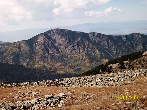
View of the Truchas group from the ridge. The terrain is mixed bands short grass and loose rock. This loose rock made the going slow along with the altitude beginning to hit hard above 12,000ft. Halfway down the ridge is the unnamed sister peak standing only 7ft lower which you divert around. The trail is visible mostly and there is a nice system of cairns to follow. I definitely recommend following this following this path closely as it does a good job of avoiding the worst spots.
![Trampas in Autumn]() Trampas Peak in peak fall color as I neared the peak of Jicarita.
Trampas Peak in peak fall color as I neared the peak of Jicarita.
The fall colors were spectacular; I think I hit the area at about as close to peak as possible. Trampas Peak was about as spectacular as any of the views. Once I got within about a half mile of the summit and had a good look at the terrain I was really hoping that there was some kind of path through what appeared to be a massive mound of boulders. Luckily there was because the terrain was as rough as it had appeared. This began about 900ft horizontally and 300ft vertically from the summit.
![Jicarita Peak flags]() Flags found at the summit.
Flags found at the summit. I finally summited (12,835ft) after close to 3.5hrs. It was cool and windy, but there are a couple wind shelters on the broad summit. To the north the drop off is steep (almost 1,000ft over a quarter mile), to the south the summit drops off much more gradually.
I took many pictures and ate some lunch before beginning the 5+ mile trek back to the car. On my way down I began to notice the clouds building off the the south and west so I made sure to not go too slowly on the way back. It took me 2.5 hours to reach the car at around 4pm.
Conclusion
I headed out from the trailhead a bit after 10am, summited around 1:25pm and got back to the car around 4pm. Distance traveled was 10 miles and vertical gain was around 2,500ft. The weather was perfect; most every day since has been much colder with rain/snow showers up high. I hope to do many more climbs in the area during this awesome time of the year.
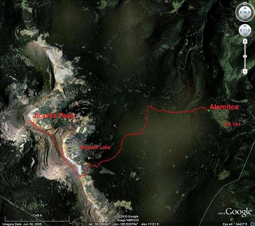
![Jicarita Peak Trail]() My path to the summit.
My path to the summit.


Comments
Post a Comment