
-
 10809 Hits
-
 83.02% Score
-
 16 Votes
|
|
Route |
|---|---|
|
|
34.28560°N / 118.1538°W |
|
|
Hiking |
|
|
Winter |
|
|
Half a day |
|
|
Trail and Fire Road |
|
|
Overview
Josephine Peak is a less often visited peak compared to its more famous neighbor Strawberry Peak. Nevertheless, the views from the summit are much less obscured than from Strawberry Peak and Josephine Peak offers gorgeous 360 degrees vistas. Josephine Peak can be climbed all year around from Colby Canyon leading up to Josephine Saddle. From the saddle the trail meets the Josephine Fire Road which winds up to the summit.Getting There
Colby Canyon trailhead is about 10 miles from La Canada Flintridge on the left side of Los Angeles Crest Highway after the intersection with the Los Angeles Forest Highway. Adventure Pass is required here.
Route Description

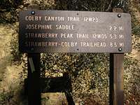
Trail heads up Colby Canyon from trailhead (3,480 feet). You pass a small waterfall on the left and cross the creek on several occasions. After about a quarter mile the trail steepens to reach lower Daisy Canyon and back to upper Colby Canyon. Above the canyon the trail switchbacks several times through chaparral and manzanitas to Josephine Saddle. The southwest face of Strawberry Peak is prominently visible here. It should be noted that this part in particular lacks shades and can get very warm even on a sunny winter day. The saddle (4,840 feet) is about 2.2 miles from the trailhead. At the saddle a trail heads east to Strawberry Peak's west ridge route that involved some class 3 climbing. The trail to Josephine Peak heads from the saddle to the west and meets the Josephine Fire Road at about 0.5 miles (4,890 feet). The fire road switchbacks on the north side of Josephine Peak several times and can be covered with snow and ice in the winter. After 1.5 miles the road finally leads from the west and south side of Josephine Peak to the summit (5,558 feet). A little wind-measuring station with some antennas and remnants of an old fire lookout tower welcome you on the top. On a clear day one has gorgeous 360 degree views of the front range of the San Gabriel Mountains, some high peaks further east, the Los Angeles Basin all the way to the Ocean and Catalina Island. From trailhead to summit one hikes about 2,078 feet in 4.2 miles one way.