
|
|
Route |
|---|---|
|
|
47.03866°N / 9.77474°E |
|
|
Sport Climbing |
|
|
Summer, Fall |
|
|
Half a day |
|
|
5.11d (YDS) |
|
|
7a |
|
|
9 |
|
|
Overview
Kamala is modern sport climbing route on the south face of the 7. Kirchlispitze; the most eastern of the seven Kirchlispitzen. The route is relatively new and has been opened in 2010 by Marcel and Kathrin Dettling. Still, the route has become one of the most frequented in the area. This popularity can be explained by the fact that the route offers sustained climbing on perfect limestone. Furthermore, the approach is short and the route is very well equipped. The crux is rather hard for grade and requires a good foot technique. The route is equipped to rappel down, but due to loose rocks on the ledges this is only safe if you're alone. Fast parties can combine the climb with the nearby routes Desu or Little Joe.First ascent: Marcel and Kathrin Dettling on 27th of june 2010. The bolting has been done on several days (seven) during 2009 and 2010.
Getting There
There are several possibilities to get to the start of the route. Most common is the approach from Grüscher Alp (Switzerland). An approach from Austria is rare and timeconsuming.To Grüscher Alp (Switzerland)
Follow a very steep and narrow road to Schuders (cross the famous Salginatobelbridge). The road continues after Schuders (no tarmac, information in the only restaurant in Schuders about toll/acces!), towards Grüscher Alp. Just above Grüscher Alp there is a small parking and a cosy mountain hut. The perfect starting point for those who want to climb the South face routes!
To the route
From the Grüscher Alp go north (direction Schweizer Tor) and turn left before the Schweizer Tor. Follow the Prättigauer Höhenweg for about 100 meters and just scramble your way up to the base of the South face of the 7th Kirchlispitze. About 30 - 40 minutes from Grüscher Alp.
Route Description
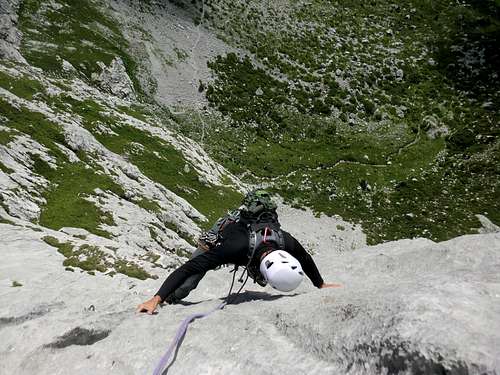
The start of the route is not marked but still easy to find. There is a very good online topo available for the route. Here you'll find details to get to the start and the topo can be printed to take along.Ascent: Kamala, 300m, 7a (6b obligatoire/obligatory). The route is bolted perfectly (Schweiz Plaisir: gut+) with 81 bolts (of which 18 on the belays).
1st Pitch - 35m - 5.11b/6c: A worthy first pitch which is difficult to onsight without a proper warm-up.
2nd Pitch - 30m - 5.11d/7a: The crux of the route. Head slightly right and tackle the very technical slab which marks the crux. Hard for the grade.
3rd Pitch - 25m - 5.10c/6b: The first part is easy and is perfect to stretch your underarms after the first pitches. The second half has some long moves.
4th Pitch - 35m - Scrambling.
5th Pitch - 35m - 5.10b/6a+: Start by climbing the chimney above the belay and then head up some slabs. Soft for the grade.
6th Pitch - 40m - 5.10d/6b+: One of the longer pitches with all kinds of moves. The next belay is left on a small plateau.
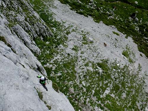
7th Pitch - 50m - 5.10c/6b: On of the best pitches of the route. 50 meters of climbing on beautiful limestone. The last meters offer awesome moves on the so-called "Wasserrillen".
8th Pitch - 30m - 5.10d/6b+: A short overhang which has some very good holds is followed by a challenging slab.
9st Pitch - 20m - 5.10b/6a+: A fine last pitch which looks easier than it is. There is a climbers log at the top (filled with water during our ascent in august 2012).
Descent: The route is equipped to rappel down, but in case of crowds it is better to use the trail which starts at the nearby Schweizer Tor. This trail can be reached by down climbing on the backside of the mountain (easy and safe). About 30 minutes to the start of the route.
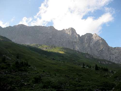 Overview of the Kirchlispitzen. The 7th Kirchlispitze is on the right side of this image.
Essential Gear
Climbing gearNormal sport climbing gear: climbing shoes, chalk, helmet, 14 quickdrawns (long pitches with a lot of bolts), double rope (2 x 50m) and enough water (south face!).
Map 1:25 000:
- SAC Map: 1156 Schesaplana
- SAC Map: 1157 Sulzfluh
- SAC Map: 238 Montafon
Online Maps:
Guidebook for Kamala: as the route is opened in 2010 it is not described in most of the guidebooks. Thanks to Marcel Dettling there is a free online topo available here: Topo Kamala
Guidebooks for climbing in the Rätikon (not for Kamala, see above):
- Rother Guidebook: Rätikon, Günther Flaig, ISBN 3-7633-1098-3
- SAC Guidebook, Bündner Alpen 7 Rätikon, Paul Meinherz, ISBN 978-3859020993
- Kletterführer Rätikon, Mario Luginbühl, ISBN 978-3-926807-38-0
To order SAC Maps: www.toposhop.ch
To order SAC Guidebook: www.sac-cas.ch
To order the Rother guidebook: www.rother.de
To order the Kletterführer Rätikon: www.panico.de
External Links
Kletterhütte Pardutz KCR - 1732 mMarco Lippuner
7232 Luzein
Phone: +41 (0)78 6604316
Homepage:www.kcr-online.ch
Other useful links:
WSL Institute for Snow and Avalanche Research SLF
Weather Forecast
Railroad information Switzerland
Bus information Switzerland