
-
 19124 Hits
-
 80.96% Score
-
 14 Votes
|
|
Mountain/Rock |
|---|---|
|
|
37.80161°N / 107.59293°W |
|
|
13220 ft / 4029 m |
|
|
Overview
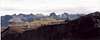
Not too many people know about this mountain. It is not a very popular mountain to climb. It overlooks a very busy area, and yet the summit is very solitude. The summit register on top had about 9 entries in about 20 years.King Solomon Mtn is an unranked summit next to Little Giant Peak, rising approximately 280 feet from the saddle. The high point is the point closest to the saddle. The map shows an elevation of 13,185 feet on a point north of the true summit. This is one of the many mountains that the true exact elevation is not known. Since neither the saddle or the peak has an official elevation, this peak has a soft rank. It could possibly rise more then 300 feet from the saddle.
King Solomon Mountain can be seen from rd 110 just outside Silverton.
This area has some really interesting history and geology. The saddle between it and Little Giant peak is covered with pretty little quartz crystals, many are perfectly shaped. To see more about it see Little Giant Peak
 |  |
Getting There
Cunningham Gulch Approach:From Silverton take rd 110 heading towards Cinnamon Pass. Take a right up Cunningham Gulch. The trail is near camp sight near the back of the valley near some campsites. The trail head can be hard to find. If you look hard enough you will see a trail heading up the mountain. You can bushwhack your way to the trail. It's an old mining trail leading to Dives Basin. The trail is very steep, and disappears sometimes near the top of the basin. From the basin you can hike Little Giant Peak or King Solomon Mtn. To hike King Solomon, hike to the right and you'll end up at the pass. From the pass head up to the peak. The rocks are loose and you have to use your hands for balance near the top. The top is a long ridge about 2 feet wide. The other approach is from Little Giant Basin. From Little Giant Basin King Solomon is the mountain to the left, and Little Giant peak is to the right.
Little Giant Basin Approach:
King Solomon Mountain can be approached from Little Giant Basin via the Arrastra Gulch access road. Drive northeast out of Silverton on County Road 110 for 2 miles. Turn right onto the Arrastra Gulch Road, across from the Mayflower Mine building. The road drops down immediately and crosses the Animas River and then climbs in to Arrastra Gulch. See the Little Giant page for more info. -AJ
Keep an eye out for a sharp left turn that doubles back north. The road is likely comparable in condition and difficulty to the Arrastra Gulch Road. 4WD experience and vehicle is required. This road will take you to Little Giant Basin. From here, both King Solomon and Little Giant Peaks can be accessed, but route specifics may be a long time coming since these mountains see little attention or traffic. According to the map, a pack/miner's trail leads one up King Solomon Mountain to a saddle from which both mountains could conceivably be climbed. -AJ
 |
Red Tape
None |