Overview
The AT in the Smokies (and elsewhere) likes to trace the top of the ridgeline. In the eastern Smokies, the naming conventions produce some funky results. A large massif such as Mt. Guyot gets broken up on the map into a series of mountains and ridges that lie more or less perpendicular to the AT. Each of these ridges has its own name, such as Inadu Mountain, and each one’s high point is labeled a “knob” (so,
Inadu Knob for example).
![Final Approach to Cosby Knob]() Approach to Cosby Knob
Approach to Cosby Knob
Since the AT likes to follow the ridgeline, you walk up and down each of these knobs - - or, in a few cases, you’re ten yards or so from the formal summit. This means that you can bag a lot of knobs in a basic AT hike. It’s so easy that you might not even know that you’re on top of a knob when you reach it. But again, each knob is the summit of its own mountain, so when you’re bagging knobs, you’re bagging peaks too. Sort of.
So that’s what we did on a nice three-day hike in November as the fall colors disappeared. Our route also took us over a “bald,”
Maddron Bald, which stood out about as much as the knobs. So we bagged a bald too.
About two miles from the end of the three-day loop, we also summitted Gabes Mountain on the Gabes Mountain Trail. Though Gabes Mountain is a “mountain,” it was actually lower than the bald and the knobs. I don’t explain it, I just report it.
Overall, it was a nice three-day weekend.
![View from Maddron Bald]() View from Maddron Bald
View from Maddron BaldReading the Guidebooks in order to do Something Else; or, The Importance of Going Clockwise
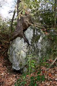
![Giant Rock-Eating Tree]() Rock-Eating Tree
Rock-Eating Tree
I didn’t plan it that way, but the route described here does a good job avoiding the crowds on one of the most-popular three-day trips in the Smokies, the Maddron Bald-Snake Den Ridge loop. By going further and higher on the AT, and by hiking clockwise while everyone else is hiking counterclockwise, we were never camping with the crowds. We did cross their paths, of course, especially on the last day.
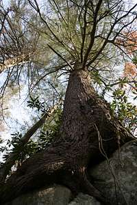
![Old Tree on a Rock]() Victim's Eye View of Rock-Eating Tree
Victim's Eye View of Rock-Eating TreeDay One: The Journey Begins
After driving 450 miles from Indy, we arrived at the Cosby trailhead (north end of the park on the Tennessee side) around 2:00 pm local time. The Low Gap Trail begins to the left of the parking lot. It’s essentially a steady traverse up the hill to Low Gap, with a stretch of switchbacks in the middle. The trail doesn’t look all that steep but it took more energy out of us than we expected. I didn’t figure out why until later - - it’s surprisingly steep despite the low elevation.
Here’s a comparison with some well-known trails. The Nevada Falls Trail in Yosemite ascends 1874 feet in 3 miles, or 625 feet per mile. Flattop Mountain Trail in RMNP ascends 2874 feet from Bear Lake in 4.4 miles, or 650 feet per mile. Low Gap Trail in the Smokies ascends 2650 feet in 3.8 miles to Cosby Knob Shelter, or 700 feet per mile. With our cold-weather equipment and three days of food, we were humping a bit more than our day climbs on those other trails.
We reached Low Gap, 2.9 miles from the trailhead, in under two hours - - slow for us, but I feel better about it after the above calculations. It felt good to arrive on top the AT but then we realized that the name “Low Gap” meant only that . . . everything else was higher! So it was uphill some more to the Cosby Knob Shelter.
This is a newly-refurbished shelter (see picture), with two large shelves for sleeping humans, and plenty of additional space for sleeping mice. All the bear cables are intact, and there’s a composting privy. Such luxury!
![Cosby Knob Shelter]() Cosby Knob Shelter
Cosby Knob Shelter
The composting privy is an experimental model. It had an electronic counter embedded in the floor mat in front of it, so that it could count each use. (Or, more technically, it counted each time someone stood in front of the privy or sat down on it, regardless of actual use.) No, I am not making this up.
There’s a seeping spring 50 yards away, with adequate flow at this time in November despite the severe drought.
Day Two: Knobbagging
We awoke to a beautiful, but cold (below freezing) North Carolina morning. The two of us had an odd number of sausages, which meant that we could share them with our only human companion in the shelter the previous night; fortunately, our non-human companions did not discover them.
![Sunrise comes to North Carolina]() Sunrise in North Carolina
Sunrise in North Carolina
We hit the trail early and easily bagged
Cosby, Ross, and Camel Back Knobs along the AT, as well as
Inadu Knob. At Inadu, we left the AT and back down into Tennessee.
After a brief descent, the trail forks to the
Maddron Bald Trail on the left and the Snake Den Ridge Trail on the right. We went left and descended down
Maddron Bald to the Otter Creek Campground. This is a former CCC work camp, with good water even in this severe drought year. There are two bear cables, one broken and one intact (with two hooks).
Having arrived just after lunch, we just chilled in camp and chatted with people as they went by. One local hiker was doing the full Cosby-Maddron Bald Trail-Snake Den Ridge route as a day hike (17.3 miles) - - not bad for a retired guy with a beagle.
![Morning on the Maddron Bald Trail]() Morning on the Maddron Bald Trail
Morning on the Maddron Bald Trail
We shared camp with a couple from Indy, who was hiking the guidebook route in the standard counterclockwise direction. By starting on a Thursday, instead of a Friday, they also missed the crowds (except for us).
Day Three: The Crowds
Again, we woke to a beautiful but chilly morning. We hit the
Maddron Bald Trail early and took the side trip to the Albright Grove of old-growth trees. Don’t miss this if you go.
From there, it was downhill on a trail that must have been either a road or a narrow-gauge rail during the days of logging the Smokies. It had a gentle descent and was fast.
At the junction with the Gabes Mountain Trail, we turned back towards Cosby. This stretch of trail gets pretty boring: you traverse out a ridge, then traverse in on the other side of the ridge, cross a creek, and repeat. One of those creeks is the Sugar Cove Campsite (#34). There were two large parties there when we passed them late morning.
![Rhododendron Tunnel on Gabes Mountain]() Rhododendron Tunnel on the Gabes Mountain Trail
Rhododendron Tunnel on the Gabes Mountain Trail
On the rest of the hike out, we saw lots of people. Some were dayhikers going to Henwallow Falls. But we met more than 20 backpackers who were on the Malloy loop, intending to camp at Sugar Cove that Friday night. Most of them were moving on to Otter Creek Campsite, which we had just left, for Saturday night.
In short, if you want to avoid the crowds, don’t hike this loop counter-clockwise on a weekend.


Comments
Post a Comment