Overview
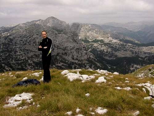
![Kokotov Vrh summit]() On the summit of Kokotov Vrh (2001 m)
On the summit of Kokotov Vrh (2001 m)
The massif of
MAGANIK stretches in east-west/northwest direction. Maganik is an aloof group of impressive limestone formations. The geological composition of Maganik is made of cretaceous bank limestone. The base of this mountain range from the Niksic side and the Moraca River valley is made up of Triassic limestone.
Kokotov Vrh (2001 m) is placed in the central part of Maganik. That peak is placed on the west side from Međeđi Vrh (2139 m), Babini Zubovi (2111 m) and Trešteni Vrh (1980 m). Because of its wonderful position, Kokotov Vrh is wonderful viewpoint to Međeđi Vrh and Babini Zubovi peaks. On its estern side Kokotov Vrh is connected with
Međeđi Vrh (2139 m) by the pass, from where going the path to Zabrđe Katun and then to Velje Duboko village. Behind the Kokotov Vrh peak is placed
Prijevor Pass (1780 m) which separate Maganik massif on two parts. On the oposite side from Prijevor is
Čakmakov Vrh (1974 m) as a connection to the ridge to
Petrov Vrh (Kurozeb, 2124 m), and then to the north to
Žuta Greda (2104 m) peak and
Rogođed (2037 m). Kokotov Vrh offer an incredible adventure to admire the impressive beauty of Maganik's massif.
Route Info
![Going to Petrov Vrh]() On the ridge of Kokotov Vrh (2001 m)
On the ridge of Kokotov Vrh (2001 m)
Duration: 3h
Height difference: 1161 m
The starting point of that route is at the lowest part of the Velje Duboko Village where Krotaja meat Mrtvica river, below the terrace where is placed the village church. After that the path cross small wooden bridge over Mrtvica River where Riječina River flows into Mrtvica River. After about hundred meters the path continue near the Minić house, below the steep slope where is the end of Ravnjak vasty plateu. After about 45 the terrain becomes more flatter, where is placed a high river's grassy terrace. The path then cross steep side of Kosmač in narrow valley of Riječina. After that you'll notice very fine plateu where you can see a few water springs, which are come from Riječina river. These springs you can find during a whole year. From here to the spring in Poljana and in Vragodol, on the southern side of Maganik, you can't find a water. Than the path continue through the forest below the Crni Vrh. After about 30 minutes from the plateu with Riječina springs the path meat a crossroad - below about 10 m high rocky plate on the left side goes the path to Zabrđe katun which is about 30 minutes far. Going through the forest to Prijevor Pass, after about 15 minutes you'll go out from the forest and come into narrow valley. Going on the bottom of that valley and crossing the rocky slopes you'll reach the Prijevor Pass (1780 m) from where you'll see western side of Kokotov Vrh (2001 m). After about 30 minutes you'll reach the summit of Kokotov Vrh. Kokotov Vrh is connected by ridge with highest peak of Maganik - Međeđi Vrh (2139 m), so if you want, you can reach the summits of both peaks.
Getting There
You can choose to approach
Kokotov Vrh from three sides - from Niksic via Laz-Kutsko Brdo-Rekocica-Maganicko Polje, from Medjurijecje via Mrtvo Duboko village and from Velje Duboko village.
By plane:
The closest airport is the one in
Podgorica (70km away).
If you are planning to come via
Serbia, you can use the
Belgrade (Beograd) Airport in Beograd (Belgrade) city, capital of
Serbia and Montenegro.
Information about flights and tickets on
JAT Airways web page.
By train:
Beograd - Kolašin (Bar - Beograd) railway passes through
Mojkovac and
Kolasin. Then by car or taxi from Kolasin to Međuriječje or Nikšić.
By Bus:
From Beograd (Belgrade):
Beograd (Belgrade) - Cacak - Uzice - Zlatibor - Nova Varos - Prijepolje - Bijelo Polje - Mojkovac -
Kolasin
Then by car or taxi from Kolasin to Međuriječje or Nikšić.
From Podgorica:
Podgorica - Međuriječje
Podgorica - Nikšić
For the bus tickets and informations about but lines see
Belgrade Bus Station page.
By car:
From Beograd (Belgrade):
Beograd (Belgrade) - Cacak - Uzice - Zlatibor - Nova Varos - Prijepolje - Bijelo Polje - Mojkovac -
Kolasin - Međuriječje (or Nikšić)
From Podgorica:
Podgorica - Međuriječje (or Nikšić)
You should drive along the central
Montenegrin highway, which connects the seaside to the towns:
Cetinje - Podgorica - Kolasin - Mojkovac - Bijelo Polje; and goes on to
Serbia (Belgrade city). This road is passable during most part of the year. It is closed only in case of abundant snowing or great rockslides. The landscape along the highway is particularly picturesque in the segment of the
Moraca River Canyon between Podgorica and Kolasin. This part of the canyon is called “Platije”. The highway is built along the edge of the narrow canyon. Thus, you can enjoy in observing the beautiful contrast between steep, dark cliffs and light, green river, while round, white peaks of Bjelasica glow in the distance. At moments, this beauty becomes scary!
Camping
If you approaching Kokotov Vrh from Morača Canyon via Međuriječje, the optimal place to stay is Velje Duboko village, placed below the massif of Maganik.
Also, the massif of Maganik is surrounded by many katuns (lodges) where people living on the mountain only during summer. Known katuns are Rekocica, Maganik, Poljana, Vragodo, Ogradjenik, Zabrdje, Razbijena Jela, Magline, Stanjevica Rupa, Besovica Katun and others, where you can freely use your tent for camping or stay in free shepherd's lodges.
Meteo Info
Before the visit of
Kokotov Vrh check the meteo info for
Kolašin and
Nikšić.
Red Tape
No extra fees.

 On the summit of Kokotov Vrh (2001 m)
 On the ridge of Kokotov Vrh (2001 m)
