Kololo Peaks in 24 hours
Not Even On The Map
Failure at home pushes me to some big mountains out there. Sometimes my life feels so void of success that I try to fill it with enormously difficult adventures. Kololo is just one such adventure. A phoenix out of the burned ruins of my hopes and dreams. I've been eyeing this beautiful mountain for the past four years and thinking about it every day. It's glaciated beauty can be seen from all the nearby peaks yet it is often dwarfed in attention by its larger sister, the lovely Glacier Peak. Most USGS maps do not label Kololo peak and if you ask a local, more than likely they will have no clue what mountain you're talking about. Even the highest point, at around 8,230 feet, is not labeled, instead a lower point to the east is benchmarked at 8,197'. To me, the obscurity and difficulty of access to it just makes it that much more special. Thanks Paul Klenke for the information on this summit. Unfortunately the route is changing drastically as the White Chuck glacier is melting away. There are new obstacles to cover from lakes to canyons and muddy creeks the consistency of quicksand. I had to change my route accordingly and with great effort. Here's the path I took:
The Crazy Climb to Kololo
I had only two days to work with before the autumn winds came. I gave myself 24 hours from Darrington at 6:20pm on Wednesday 9-11-2013 to travel 82 miles, gain well over 8,000 feet and cross some serious glacier terrain. It was a speed run for Kololo packed as light as I could (mostly just jacket, ice axe, crampons and gu) moving as fast as I could. The biggest obstacle was the bus. If that worked out, everything else was cake. I was psyched for this journey and ready to push hard for something beautiful that wasn't about to deny me if I wasn't interested in quitting. Luckily the buses worked out great and I made it to Darrington right on time, an hour before sunset.
Now for the easy part: unleashing the rage.
![Last Stop in Darrington]() The last stop in Darrington.
The last stop in Darrington.
| ![Whitehorse from the neigborhood]() Whitehorse taken from somebody's front lawn. What a view!
Whitehorse taken from somebody's front lawn. What a view!
|
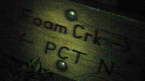
Biking from Darrington to the North Fork Sauk was one of the hardest sections since that was when I was bearing the most weight. But I had brought an mp3 player for motivation and made it to North Fork Sauk Road before it even got dark. Seven tough miles later I signed in the trail register that I was working on a Darwin Award Nomination and placed destination as "Kololo or Death". My legs were really starting to feel it so I took a rest at the Pilot Ridge Trail junction and hid a can of chili that I would devour on the way down (planning ahead for protein shake). At Mackinaw Shelter I had a fine dinner of two large home-cooked bean, cheese and jalapeno burritos and guzzled a liter of water for the upcomming grind to White Pass. Metallica, Tool, Neil Young, Soundgarden and Pearl Jam raging through my mind channeled some midnight fury all the way. I pulled them out briefly to consider the stars and vast darkness before planning my next move at the PCT/Foam Creek Pass junction (aka White Pass).
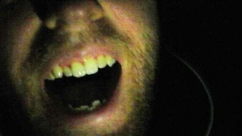
The excitement of having gotten this far in a quarter the usual time was electrifying
![Ecstatic]() Ecstatic about my first 30 miles in the dark!
Ecstatic about my first 30 miles in the dark!
| ![Foam Creek/PCT junction]()
Happy to provide proof of it too.
|
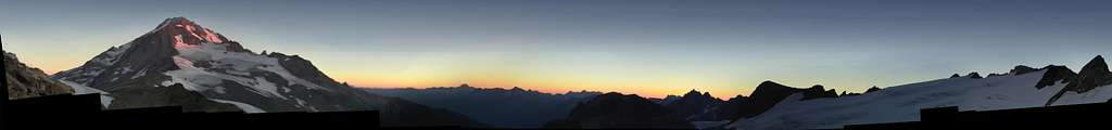
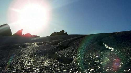
Finding Foam Creek Pass in the dark was not easy since it is barely discernible from its surroundings and shoots steeply down-hill in a way that would suggest I was not even on a trail. The worst part was the soil since it had rained a few days prior the stuff resembled hardened kitty litter. It broke easily when stepped upon and tended to roll down-hill. But it turned out to be the correct path and I was working my way up towards White Chuck Glacier within the hour. At some point I crossed around the edge of a lake, at first glancing noticing a large black hole in the earth with stars shimmering on its surface. My heart jumped since I know there's not supposed to be a lake there. I came across more of these as I ventured North. When I got to the foot of the White Chuck, it was melted into a soupy-like substance made of glacial flour and melt-water that ran into deep runnels that formed miniature canyons that fell away into new lakes down below to the West. Looking up the glacier to the East it was riddled with crevasses. I tried to approach its snout but each time I fell into a quick-sand like mud that had me cursing and thrashing. Eventually I gave up, cleaned up and headed for Glacier gap, opting to either climb Glacier Peak or try Kololo from the North via the Suiattle Glacier. Well, even just doing that much was a bit of trouble as the surroundings were unfamiliar since the White Chuck was so far gone. There were canyons where there used to be easy snow and lakes where there used to be glacier. I was pretty astounded. Several times I had to re-figure where I was since my map was utterly useless at describing my actual surroundings. I lost several hours figuring out how to get back on route to Glacier Gap and made it only half an hour before sunrise. I pulled out the ax and crampons to get to a high point above Glacier Gap for the sunrise. It was a gorgeous sight.
![Glacier Peak Alpenglow just before sunrise]() Not the best picture but I love this mountain!
Not the best picture but I love this mountain!
| ![Koteepah Divide]()
Kopeetah or thereabouts...
|
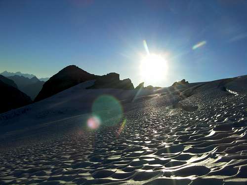
I briefly considered Glacier Peak but decided against it having had my fill of Kitty Litter soil at Foam Creek Pass and White Chuck glacier basin. Most of the route up Glacier Peak would be much the same since it is volcanic pumice interspersed with large rocks. Later in the route it would be very dangerous either at the ice-fall on the Cool Glacier or the class 4 choss if I took Disappointment Peak since the glacier was deeply crevassed right on route and the class 4 section would be only held together by that kitty litter crap. Still it was pretty to look at. From this vantage above Glacier Gap, I made my decision to go for Kololo via the Suiattle Glacier since I could see an easy path around all of the crevasses. At the time I thought it was the Honeycomb Glacier and had the two mixed up. I slowly picked my way up the glacier looking to avoid all crevasses since I was solo. The snow was ablated below 7,000' and summer like above. I tested each step with my axe to make sure it wasn't too punchy to bear my weight and took my time to stay on route away from some of the more heavily crevassed areas.
![Glacier Peak Alpenglow still]() another one for my favorite volcano
another one for my favorite volcano
| ![Crevasses on the Suiattle glacier after Sunrise]() there is some moderate dripping on the crevasse edges... a reminder to keep moving quickly and carefully!
there is some moderate dripping on the crevasse edges... a reminder to keep moving quickly and carefully!
|
![Near the top of Suiattle Glacier]() Nearing Kololo's summit on the Suiattle Glacier
Nearing Kololo's summit on the Suiattle Glacier | ![Too Many Crevasses to go that way]() Fun to look at but better to avoid.
Fun to look at but better to avoid. |
The last little bit got steep as I headed for the western most high point (8,200'+). The highest summit, 8,230', was not reachable without spanning a moat so I traversed from the west on easy but loose class 2 after ditching my crampons and axe on the last patch of snow. I was becoming more tired so my thoughts were just focused on the view and capturing it on camera to enjoy it more later. From here I could see everything! Triple Volcano views, Beautiful blue ridges and glaciers all around me. The sun had just risen only less than an hour before and the light was pretty good. Unfortunately the camera would not store my pictures due to an internal error so I had to take video then turn it into stills. Some of them still turned out alright.
I'll post the video later.
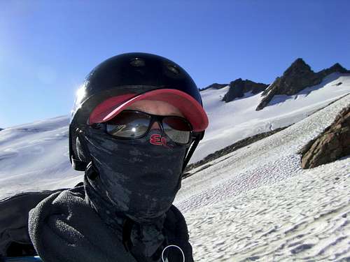
I wanted to stay up there forever but the sun was rising and the radiation was coming down. I knew those snow bridges were going to be getting dangerous so I made my escape before they thawed, passing some of the crevasses closely. I took some video as I went and later turned those into stills. Most of the footage is garbage since the lens sensor was stuck zoomed in and picked up a ridiculous amount of shaking. I still managed some decent ones. Being a ginger beard with a severe sun allergy I had to cover my face at some point. I'd like to leave the audience with the caution that you should always rope up with a team on a glacier. I probably chose the best time of the year and day to be up there but it was still risky. I can accept those risks on my own but I would never want to put myself in the same situation with others present.
![Crevasse shadow]() One of a few crevasses I had to carefully cross close to on a snowbridge. Upper margin of the Suiattle glacier
One of a few crevasses I had to carefully cross close to on a snowbridge. Upper margin of the Suiattle glacier
| ![Lower Suiattle Glacier]() taken from midway on the Suiattle glacier
taken from midway on the Suiattle glacier
|
![Deep Crevasse]() Deep
Deep | ![Route Looking down]() Route back to Glacier Gap
Route back to Glacier Gap |
![The Hive]() neat little lakes forming around its base
neat little lakes forming around its base | |
![Last Glance at Glacier]() last glance at Glacier Peak
last glance at Glacier Peak
| ![Looking back at the morning on Kololo]() Just finished getting back to Glacier gap after soloing the Suiattle Glacier to Kololo's summit. The snow was pretty solid during the morning hours and the crevasses were obvious but I don't recommend it unroped
Just finished getting back to Glacier gap after soloing the Suiattle Glacier to Kololo's summit. The snow was pretty solid during the morning hours and the crevasses were obvious but I don't recommend it unroped
|
Burning Out then Fading away
The way down was way easier to navigate in the daylight but my energy was fading fast. By the time I got to Foam Creek Pass I was really feeling the heat. I pushed the water hard but it was no use with the combination of miles and lack of sleep. I could only go a pace of about 3mph down hill even though I had hoped to be running by this point. I took a little break behind some trees near the Red pass turn off and said hello to a couple heading up there for the rest of the week. I tried to take some photos of Mt. Johnson but again the camera was not committing them to memory (it would click and flash as if it took a picture, fooling me then and disappointing me later). I dragged my feet down to Mackinaw and by that point they were getting sores and I was feeling the distance. The sun began to sag and I knew time was running out. Still, I didn't want to be totally miserable so I took a dip in the river and got a belly full of water for the way out. Feeling much better I strode briskly to the trail-head and said hello to a couple going in. They gave me the time, 5:15pm and from that point I knew I had taken too long. I rode my bike as fast as I could anyways keeping about a 20mph pace until I hit my first hill going out on the Mountain Loop highway. It was at this moment that my mp3 player died. Then I knew I was done for.
I eeked out the next few miles dragging the bike 1mph up hill then 30mph down until I was only 10 miles out of town. Then I saw a car in the distance headed to Darrington and thumbed them over. They were kind folks. They couldn't give me a ride but they gave me some food and took a message to deliver to my family so that they knew I would be late but I'd be alright. The next passer by gave me a lift into town. So I guess I only did 72 miles instead of 82. Still not bad, huh? We got to talking and he provided some interesting conversation about restoration efforts of the Monte Cristo area. He dropped me off at the IGA store which was next to a motel where he was staying that night. I got a free front-row seat to a street performance and some other interesting goings-on at the town water hole. When that died down I went over to the motel and had a chat with a woman from the mountaineers about fire lookouts in Washington. After a while the guy who gave me a ride saw I was still out of luck and helped me find a place to stay for the night. I owe him quite a debt of gratitude since we had only just met.
The following morning I headed out and caught my bus home feeling sore and beat as hell. But I was feeling great on the inside having met a bunch of cool people in Darrington and having completed my goal of Kololo peak the previous day. It rode me all the way home leaving me smiling at my little slice of heaven.


Comments
Post a Comment