Krzyżne to Skrajny Granat

Krzyżne to Skrajny Granat

Page Type Page Type: Route
Location Lat/Lon: 49.22690°N / 20.04269°E
Additional Information Route Type: Hiking, Scrambling
Seasons Season: Summer, Fall
Additional Information Time Required: Most of a day
Additional Information Rock Difficulty: Class 4
Additional Information Difficulty: comparable to via ferrata grade 2 (B)
Sign the Climber's Log

Overview

E Part of Eagle Path
The ridge our route runs along seen from the south


The route depicted here is the eastern section, roughly one third, of the Orla Perć (Eagle Path), which has had its SP page for a few years now. Still, I believe a separate page for this section is needed as the Eagle Path page, despite being rather extensive, only devotes two sentences to it.

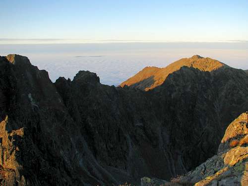
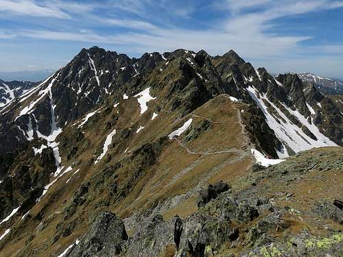
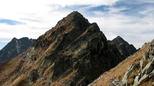
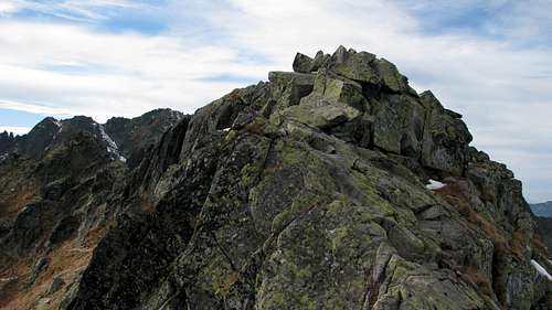
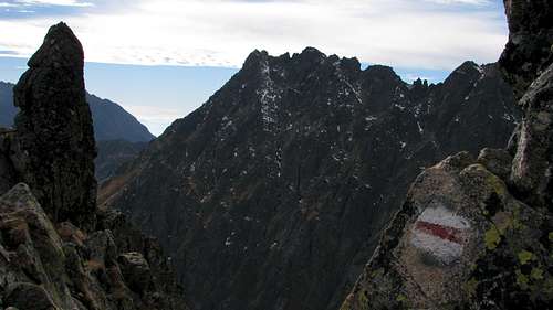
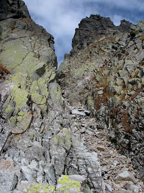
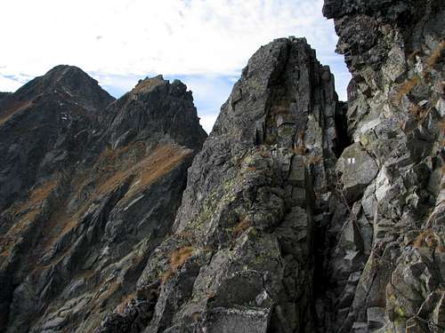
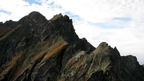
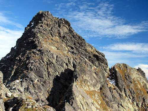
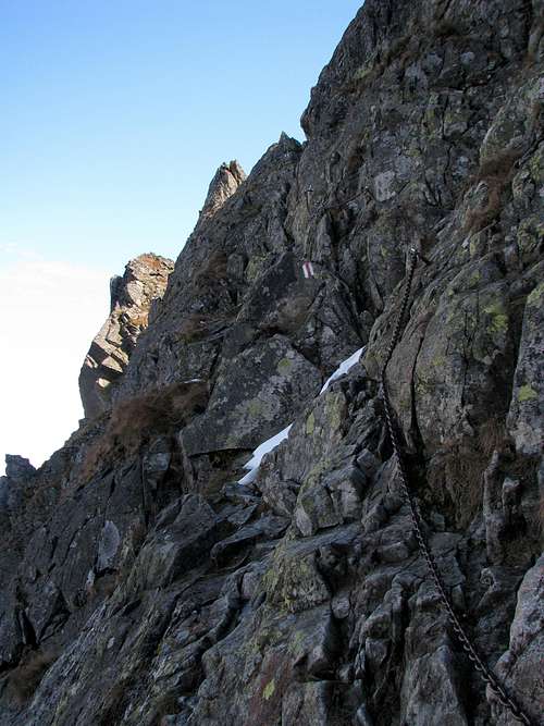
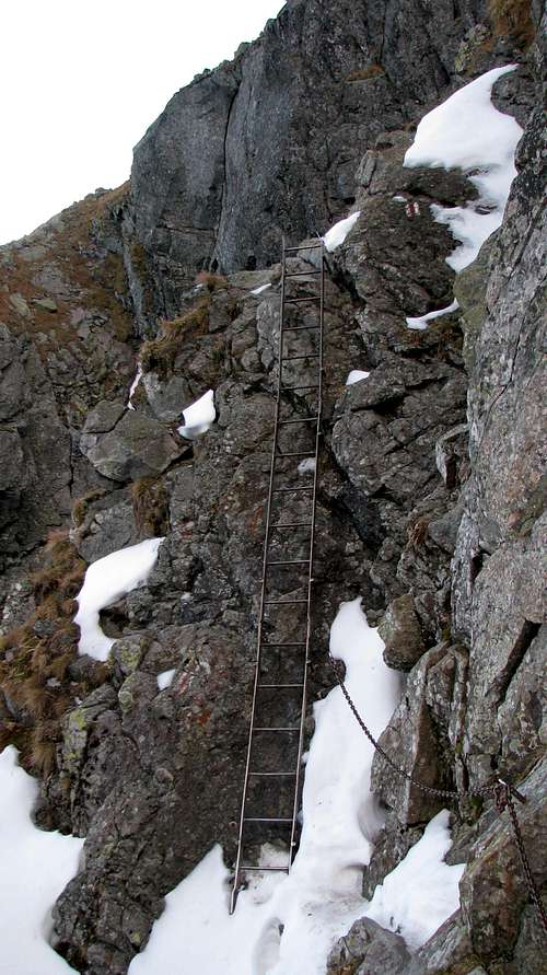
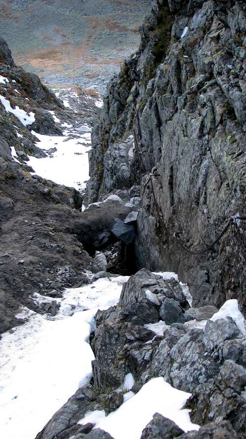
The Orla Perć is often called a via ferrata, which is misleading since – despite the metal chains, brackets and ladders as well as being comparable to the Austrian/German via ferrata grade 2 (B) – it is NOT a via-ferrata like those in the Alps. There is no cable to which you could clip yourself, which means that you are unprotected unless you clip yourself to the chains. This is possible and recommended by the national park authority but it is awkward and hardly anybody bothers to do so.

Compared to the western section of the Orla Perć (west from Kozi Wierch), its eastern section is equally demanding. It is a bit less frequented (as it is a long way from the cable car station) and the park's authorities seem to care a bit less about its maintenance too. Also, the rock is a little less solid here, and the trail tends to get damaged every few years. Finally, this is the longest section of the Orla Perć devoid of a waymarked exit.


Route Statistics & Approach/Descent

Route Net Elevation Gain Approx. Total Elevation Gain Approx. Time of Whole Hike Approx. Length of Hike
From Krzyżne to Skrajny Granat
("core route", i.e. what this page focuses on)
113 m
445 m
2 hr 30 min
 1.5 km
From Skrajny Granat to Krzyżne  
("core route" in reverse)
-113 m
330 m
2 hr 
1.5 km
Loop from Zakopane (Kuźnice) through Hala Gąsienicowa
(Zakopane-Hala Gąsienicowa-Krzyżne-Skrajny Granat-Zakopane)
1215 m
nearly 1800 m
10 hr
21.5 km
The above plus Zadni Granat (Zakopane-HG-Krzyżne-Skrajny Granat-Zadni Granat-HG-Zakopane)
1240 m
1850 m
11 hr
 over 22 km
Loop from Murowaniec Hut on Hala Gąsienicowa
(Hala Gąsienicowa-Krzyżne-Skrajny Granat-Hala Gąsienicowa)
725 m
1,175 m
7.5 hr
11.5 km
Hut on Hala Gąsienicowa-Krzyżne-Granaty-Kozi Wierch-Hut in Dolina Pięciu Stawów*
790 m
over 1,500 m
8.5 hr
12 km
Loop from Hut in Dolina Pięciu Stawów: DPS-Krzyżne-Granaty-Kozi Wierch-DPS*
850 m
over 1,200 m
7.5 hr
9 km
Polana Palenica-Dolina Pięciu Stawów-Krzyżne-Skrajny Granat-Hala Gąsienicowa-Zakopane
1,240 m
1,650 m
8 hr
23 km
             *includes the middle section of the Orla Perć too
The "core route" begins at przełęcz Krzyżne (Krzyżne pass, 2112m), sitting on a lateral ridge which branches off the main ridge of the Tatras at the summit of Świnica. Krzyżne is over four hours' walk along waymarked trails from the outskirts of Zakopane. From the hut on Hala Gąsienicowa (Gąsienica's Pasture) it takes – via a place called Dubrawiska and the valley of Pańszczyca – nearly three hours to walk up to Krzyżne. An ascent from the other, southern side is a little longer. From the trailhead at Polana Palenica (car park, "Morskie Oko" minibus terminus) you walk three quarters of an hour up the tarmac road to Mickiewicz Falls, where you turn right into the valley of Roztoka. A walk up the valley to/near the spot where the mountain hut stands by one of the Five Polish Tarns (Pięć Stawów Polskich) is expected to take two and a quarter hours. From the hut it takes another two and a quarter hours to get to Krzyżne.
Ridge of Kościelec from trail to Krzyżne
Between Hala Gąsienicowa and Krzyżne
From Skrajny Granat, a descent to Zakopane – first via yellow marks – should last about three and a half hours. But if – on reaching Skrajny Granat – you do not feel like leaving the crest and parting with the Eagle Path yet, you can carry on following the red marks and the ridge of Granaty for twenty five minutes (to Zadni Granat at 2,240m) or more (as far as Kozi Wierch, at which the one-way section of the Eagle Path ends). Some of the possible variations of the route (all of them waymarked) are listed in the table above. All variations can be seen on the map just below.

Online Map

Headwall of Pańszczyca Valley
From N
Buczynowe and Woloszyn ridge - Polish Tatras
From S

Route Description

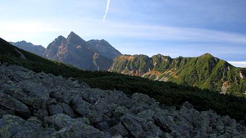
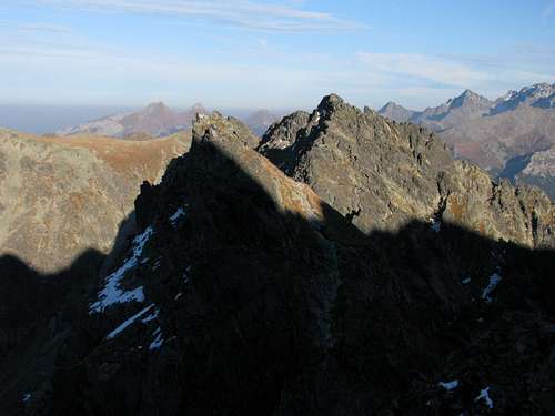
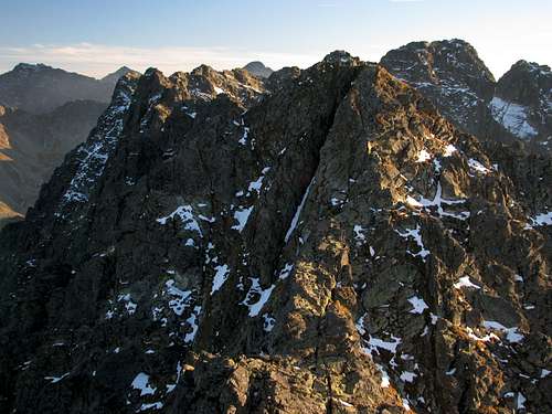
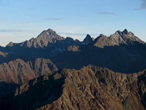
Krzyżne pass and its environs commands an excellent panorama of the High Tatras, from their east to their west end. There is plenty of room there to sit down and take in the views, while having the deserved rest and snack after a tedious – one and a half to two hours’ – walk up from the bottom of the valley. Several hundred metres under your feet sit the beautiful tarns of the Dolina Pięciu Stawów Polskich (Valley of Five Polish Tarns).  

High Tatras from Krzyżne (labelled pano)
Labelled panorama of the High Tatras from Krzyżne
 
Our route begins as a nearly horizontal traverse of Kopa nad Krzyżnem and a spire called Ptak. A comfortable walking path leads you across the south, grassy side of the ridge for several minutes.
Orla Perć
Krzyżne pass and the beginning/end of Orla Perć in May - by Konrad Sus
Soon ahead of you rises a not very tall but fairly good-looking peak. This is Mała Buczynowa Turnia, whose highest summit reaches 2,172m. 
Mała Buczynowa Turnia from E
Mała Buczynowa Turnia ahead (October 2013)
You walk up a little to soon stand on a fairly narrow ridge, at the east end of the elongated crest of Mała Buczynowa Turnia. For a few minutes you can enjoy an easy crest hike. 
On Mała Buczynowa Turnia
Near the eastern summit of Mała Buczynowa Turnia 
Unfortunately the Eagle Path, contrary to your expectations, hardly ever follows the crest of the ridge. So, to your disappointment, instead of ascending the dominant Wielka Buczynowa Turnia (2,184m), it drops down over a hundred metres, first very gently, then – assisted by chains – steeply into the chute separating the south sides of Mała Buczynowa and Wielka Buczynowa turnias. 
The gate
After this gate, the somewhat annoying steep descent begins.
Chute below Buczynowa Przełęcz
The chute seen from where the trail leaves it.
(The chute provides a relatively easy, unmarked exit from the Orla Perć, but it must not be used unless in an emergency.) After leaving the chute, the trail begins to regain elevation, traversing the south face of Wielka Buczynowa Turnia a long way away from its summit.
Traversing Wielka Buczynowa Turnia
On the traverse. Far left: Skrajny Granat (2,225m). Nearer: Orla Baszta (2,157m).
The next stretch of the ridge, called Buczynowe Czuby, will be first traversed on its south side, without difficulty. Half way down this stretch, the trail crosses the ridge and begins, losing elevation, to diagonally traverse its north face. This, like the traverse of Orle Turniczki (see the third photo below), ranks among the most exposed sections of the trail. After returning onto the crest, the trail climbs Orla Baszta to pass within several vertical metres of its summit (easily accessible). 
Buczynowe Czuby
Buczynowe Czuby (right); Orla Baszta and Skrajny Granat beyond them.
Orla Baszta (Eagle Turret), besides being a fine, bold peak, affords a magnificent view of the west side of Wielka Buczynowa Turnia.
Wielka Buczynowa Turnia from Orla Baszta
Wielka Buczynowa Turnia (2,184m) seen from Orla Baszta.
Now it is time for the aforementioned, exposed traverse of the north face of Orle Turniczki. 
Traverse of Orle Turniczki
The north face: Typical piece of traverse
On the traverse, which includes climbing down a steel ladder (about four metres tall), you will be losing elevation. 
 
Ladder below Orle Turniczki
The ladder
The traverse will lead you to the chute dropping from a col named Granacka Przełęcz. You are to climb up this chute, which can get a little tricky, depending on how slippery it is at the time. In addition, part of the scree filling the chute – along with a few metres of the chain-assisted path – has been eroded away recently, and this process is likely to continue. Hopefully, the national park authority will have this section of the trail reconstructed. 
Chute below  Granacka Przełęcz
Damaged trail
From Granacka Przełęcz at 2,145m, it takes about twenty five minutes (chains, exposure too) to cover the last eighty vertical metres of our route. Finally, you set foot on the summit of Skrajny Granat, which makes for another excellent vantage point.
E from Skrajny Granat
Looking back - east from Skrajny Granat
S from Skrajny Granat
Middle part of Eagle Path (Granaty) - south from Skrajny Granat
Looking towards Gerlach and Rysy
Looking southeast, towards the highest peak in the Tatras

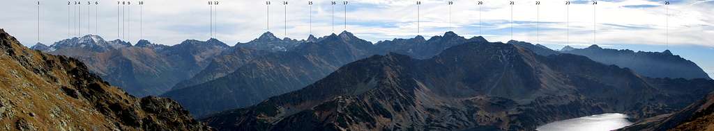
When To Climb & Essential Gear

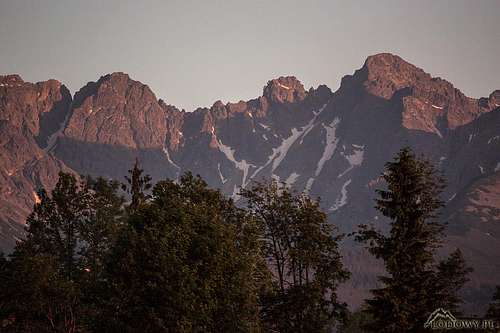
Please have a look at my Świnica to Kozi Wierch page to see photos of the Orla Perć taken on several different dates. This route is a hiking trail which makes sense when there is virtually no snow or ice on the ground and the rock is dry. That is why only "summer, fall" has been selected for the "season" row within the page profile at the top. The main problem with the summer is the crowds which come along with the school holidays. Weather permitting, September is better since it sees fewer people - just university students are still there. A weekday in October seems to be the best choice, however, it must be the right October and the right part of it (all of my photos on this page were taken on 8 October 2013: sunny day, dry rock most of the time, no verglas, hardly any snow, hardly any people). In recent years, the Tatras have experienced very changeable weather conditions in September and autumn. Wintry spells alternate with summerish ones. If you decide to go in summer, an early start, say about 3 a.m., will let you avoid the crowds as well as a possible thunderstorm. An example of what often happens in summer is given here.

High Tatras from Krzyzne Pass
A May view from Krzyżne.

Hiking boots or approach shoes are a must. Gloves can be helpful (the chains can be cold or slippery). Consider a via ferrata set and a helmet. Bear in mind that about two-thirds of all recorded accidents on Orla Perć are triggered by slips on snow, ice (which may not be seen until you step on it) or just wet ground.  In winter conditions, if there is plenty of snow and the chains, not to mention the paint marks, are buried under it (which is normal in winter and early spring, but can happen in autumn and occasionally in summer too), you would need the full range of mountaineering gear, lots of experience, a partner and avalanche awareness. If there is less snow, an ice-axe and crampons, and the skills of using them may suffice.

Red Tape

 
On Skrajny Granat
8 Oct 2013
Wandering off the waymarked trail and bivouacking are not permitted.

Mountain Conditions

It is essential that you check the weather forecast.

Accommodation

  • Murowaniec (the hut on Hala Gąsienicowa) 
  • Pięć Stawów (the hut in the Dolina Pięciu Stawów) 
  • There are plenty of guesthouses and other types of accommodation in Zakopane and nearby villages. When booking online, I usually use this site
Glossary:
Wszystkie miejscowości - All villages and towns
Wybierz rodzaj obiektu - Choose accommodation type
Apartamenty – Self-catering flats/apartments
Szałasy i domki - Chalets Ośrodki wypoczynkowe – Lower standard hotels/guesthouses/holiday camps 
Pensjonaty – B&B/guesthouses Wille – B&B/guesthouses
Wynajem pokoi – Guesthouses Hotele – Hotels (varied standard)
Campingi - Campsites Motele – Motels
Pola namiotowe – Rudimentary campsites
Noclegi/Kwatery/Zakwaterowanie - Accommodation
Szukaj - Search
Buczynowa valley from Majerczykowka
From afar (telephoto)

Maps, Books, References

A 1:25,000 map of the Polish Tatras, such as this, is good enough while a 1:50,000 is NOT. Usually several versions are available at bookshops, souvenir shops and street stands in Zakopane. I can recommend a special, 1:5,000 map of the Eagle Path by Sygnatura, which I used as a reference, especially while working on the second chapter. The same goes for the following guidebooks (unfortunately not available in English) Another map at a scale of 1:5,000 has been published by WiT. It is less detailed than the Sygnatura map, but made of plastic and has a 1:30,000 map of the Polish Tatras on its back.


Related 

Friends

Related objects are relevant to each other in some way, but they don't form a parent/child relationship. Also, they don't necessarily share the same parent.