
-
 3177 Hits
-
 76.66% Score
-
 7 Votes
|
|
Route |
|---|---|
|
|
46.06066°N / 8.85758°E |
|
|
Hiking, Skiing |
|
|
Spring, Summer, Fall, Winter |
|
|
A long day |
|
|
Hike, ski or snowshoe tour |
|
|
Overview
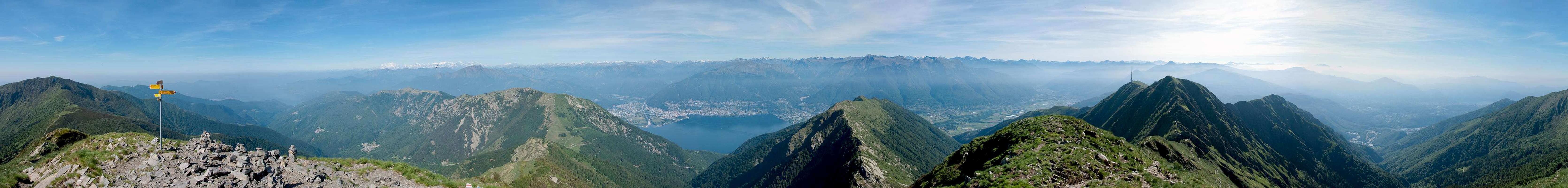
 On La Traversata between Monte Magno and Poncione di Breno On La Traversata between Monte Magno and Poncione di Breno |
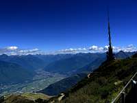
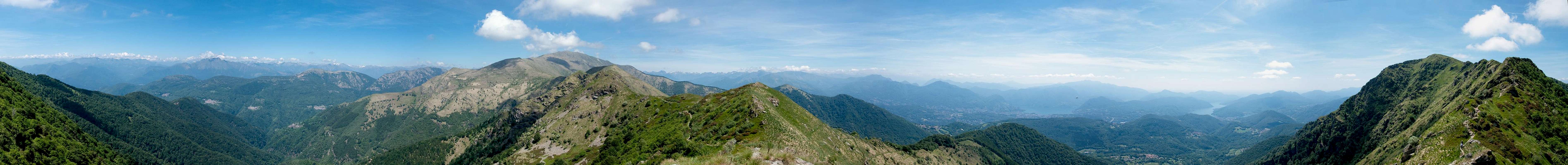
La Traversata, the ridge traverse on the western ridgeline between Lago Maggiore and Lago Lugano is one of the classic hikes of Tessin / Ticino and even of all of Switzerland. Between Monte Tamaro in the north and Monte Lema in the south it touches eight summits and offers a grand view across the Ticino lakes as well as a huge part of the alpine main ridge between Monte Rosa and the Bernina Group. Both starting points can be reached by cable-car and are connected by a bus service at the base. In consequence you'll find La Traversata very crowded. The eight summits are
- Monte Tamaro (1961m)
- Monte Gradiccioli (1935m)
- Monte Pola (1741m)
- Monte Magno ((1636m)
- Monte Magino (1589m)
- Monte Zottone (1567m)
- Poncione di Breno (1653m)
- Monte Lema (1620m)
The ridge traverse is a hike - there are no difficult sections. Reaching some of the summits, which lie besides the official route, requires some scrambling and easy climbing skills but is not neccassary - strictly speaking. None of the summits reach more than 2000m, so that the traverse can be done very early in the season. In winter it is quite obviously a very popular ski and snowshoe tour. The one way hike takes about 4 1/2 hours and the return trip will take a whole day. When started from the road saddle Alpe di Neggia, the shortest access to Monte Tamaro, you will take similar times but the traverse gets more difficult and scales more elevation. Also, this alternative should only be done after all the snow on the Tamaro north face has melted.
Getting There
 The first part of a Traversata between Alpe di Foppa and Monte Gradiccioli
Trailheads and endpoints of La Traversata are the cable cars to Monte Lema from Miglieglia and to Alpe Foppa from Rivera. Both starting points are located to the east of the ridge close to motorway A2.
- For the Rivera trailhead leave at the exit Rivera and follow the signs to the cable-car.
- For Miglieglia leave to motorway at the exit Lugano Nord but follow the signs to Breno. In Breno follow the signs to Miglieglia and the cable-car to Monte Lema.
Route Description
 Monte Gradiccioli from Passo Agario
- General:
- Start altitude: 1530m (Alpe di Foppa), 1390m (Alpe di Neggia)
- Summit altitude: 1961m
- Prevailing exposure: N, later E and W
- Type: Hike
- Protection: None
- Start altitude: 1530m (Alpe di Foppa), 1390m (Alpe di Neggia)
- Effort: 2 - Elevation gain: 920m one way
- Power: 2 - Easy, return trip very strenuous
- Psyche: 1 - No exposure
- Difficulty: 1 - Easy
- Orientation: 1 - Marked paths
There are two alternatives to get to Monte Tamaro, the first summit of La Traversata. One is described here, as it is considered part of La Traversatta, the other is described here: West Ridge from Alpe di Neggia.
 |  |  |
La Traversata starts at the upper cable-car station at Alpe di Foppa (rather Corte di Sopra). There you should first visit the church Santa Maria degli Angeli by Mario Botta, a striking piece of modern architecture, before you set out onto the first stage of the traverse. This at first follows a narrow road towards the Manera Radio Tower, which is based on a shoulder of Motto Rotondo. There you also will find the Capanna Tamaro Hut.
 |  |  |
From Manera a narrow hiking path takes you into the north face of Motto Rotondo, avoiding the summit and rejoining the ridge in the saddle, which separates Motto Rotondo from Monte Tamaro. Another path joins in this saddle, coming up from Alpe Duragno and Rivera beneath. Together, they head along Tamaro's east ridge straight for the summit. There is a four way intersection right beneath the top with one path leading through the Tamaro north face in the direction of Alpe di Neggia, the other avoiding the summit and heading for La Traversata directly. For the best views of the tour, however, stay on the ridge and head for the broad summit plateau of Monte Tamaro (1961m).
  |
Descending the Tamaro south ridge you will understand why there is a shortcut from the east ridge, avoiding the summit. It is very steep and leads into the saddle Bassa di Indemini very quickly. From there a slight ascend leads to Alpe Canigiolo and onwards to Basso di Montoia. Here the regular route heads onward across the west slopes of Monte Gradiccioli while another (unmarked) path stays on the ridge towards the mountain. The final ascent of the Gradiccioli north ridge is steep and rocky, one of the more difficult and exposed sections of La Traversata.
 |  |  |
From Monte Gradiccioli follow its broad south ridge to where the regular route rejoins it. Together they descend to Monte Pola, which is little more than a slight bump on the ridge. From there a steep path heads down to Passo Agario, an important crossroads between the Swiss and Italian parts of Malcantone. The international border between the two countries comes up from Lago Maggiore here and stays within 1km to the west of the La Traversata Route from here on.
 |  |  |
After the pass a quick series of three summits is passed: Monte Magno (1636m) is avoided and passed to its east. The next summit, Monte Magino (1589m) is traversed while Monte Zottone is passed to the west. You can reach the tops as well, but since the risge is quite rocky and narrow in this section it requires a bit of scrambling and bushwhacking.
 |
The next section is arguably the nicest part of the traverse. You follow the ridge southwards, heading for Poncione di Breno. The ridge is still narrow and leads across several fore-summits of the Poncione, always staying on top. Some of the summits are rather steep, there is a protected section to one of them. With several ups and downs it leads to the summit. Again, like on Monte Gradiccioli, the regular path avoids the summit itself but you can reach it pathlessly.
 |  |
From Poncione di Breno (1653m) you gradually descend into Forca d'Arasio across Piano del Poncione. From the saddle a steep path leads up to the cable-car station on Monte Lema (1620m), from where you can reach the summit in a further ten minutes.