
-
 4220 Hits
-
 75.81% Score
-
 6 Votes
|
|
Route |
|---|---|
|
|
46.10387°N / 8.86599°E |
|
|
Download GPX » View Route on Map |
|
|
Hiking |
|
|
Spring, Summer, Fall |
|
|
Less than two hours |
|
|
Hike |
|
|
Overview
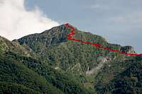
 Monte Tamaro seen from the route near Tamaretto Monte Tamaro seen from the route near Tamaretto |
Monte Tamaro is easily one of the most popular mountains in Ticino, thanks to the cable-car to Alpe Foppa, which stops about 300m beneath the summit to the west of it. So the regular route is a matter of less than an hour, walking among the crowds which head for the top or the famed traverse of La Traversata which takes them to another cable-car at Monte Lema in the south.
Another, also popular, route starts at the saddle, which separates Monte Tamaro from Monte Gambarogno at Alpe di Neggia and which follows the west ridge of the mountain, staying on the northern side of the ridge, almost all the way. The final ascent follows the short and steep north ridge.
In character route is little more than a hike, even a short one, as you need less than two hours to scale the elevation difference of some 600m. It is long enough, however, to prevent you from completing La Traversata thereafter, if you intend to return to your starting point (a good idea since bus service from Monte Lema to Alpe di Neggia requires changing buses at least twice.
Getting There
 A whole stone cairn family awaits you on the summit of Monte Tamaro
Alpe di Neggia can be reached from Locarno or Bellinzona by taking B13 to Quartino. From There drive through Magadino to Vira. Here the road to Alpe di Neggia turns off to the left and takes you in many switchbacks to the saddle.
Alternatively there is the option to take the bus from Magadino which runs three times a day across the saddle to the village of Indemini.
Route Description
 Alpe di Neggia, a saddle with a view
- Start altitude: 1395m
- Summit altitude: 1962m
- Prevailing exposure: N
- Type: Hike
nbsp; - Protection: None
In the saddle there are signs to Monte Tamaro. Cross a short alpine meadow to reach the base of the ascent, which quickly takes you to the edge of the forest, where the route vanishes beneath the tree canopy. The first part is rather steep before the trail lies back. It stays close to the ridge in this section, always on the northern side, but there is an alternative path on the southern one as well.
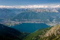
After half an hour you reach Tamaretto, a western side summit of Tamaro on which there are abandoned Swiss military barracks, which offer a sweet view across the northernmost part of Lago Maggiore to the Ticino Alps beyond.
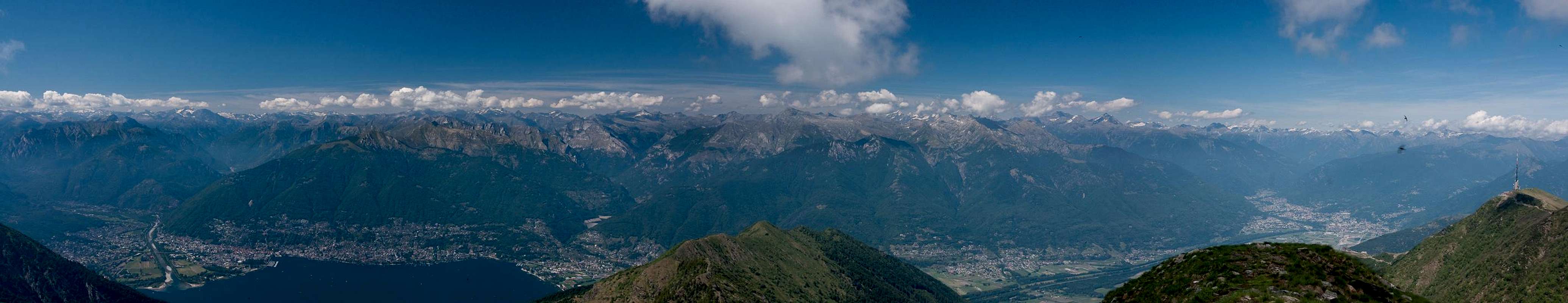
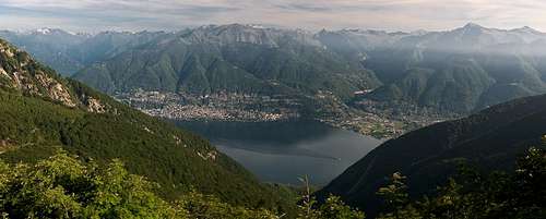 Lago Maggiore seen from Tamaretto
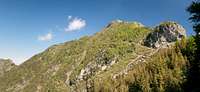
From the barracks on Tamaretto the trail heads back to the northern side of the ridge and winds towards a slightly pronounced saddle, which separates Tamaretto from Monte Tamaro proper. The ridge itself now turns steep and ends in a rocky buttress. The route again heads to the northern side where it steadily rises, passing the buttress to the left.
This traverse ends in a path intersection. Here a path turns off to the left, heading for the lower north ridge of Tamaro and its side summit Poncione del Mocello. Our route leads straight ahead (eastward) and quickly leads to another intersection. Here we turn right onto the upper north ridge of Tamaro.
 |  |  |
(Instead you can also take the eastward bound trail which heads through the north face of the mountain in the direction of Alpe Foppa. From there you can return along the easier east ridge towards the summit.)
  |
The remainder of the route is short but steep. A good number of switchbacks lead you almost directly to the summit, where there is a summit cross with a big base, a good place to sit down and take in the vista.
Gabriele Roth - Aug 27, 2013 9:24 am - Voted 10/10
season ...I've been there in april, with snow the route is a little tricky and a little dangerous in the higher part ... iceaxe needed ! normally on the N side of the mountain there's snow up to the beginning or mid june ..