
|
|
Route |
|---|---|
|
|
44.18390°N / 71.3913°W |
|
|
Mountaineering, Ice Climbing |
|
|
Winter |
|
|
Most of a day |
|
|
Steep Snow, WI 1-2 |
|
|
III |
|
|
Overview
Landslide is one of several gully climbs on the West slope of Mount Webster. This is the closest climb to the plowed parking lot at the bridge, and is a fine long moderate mountaineering outing.This route has also seen ski descents.
Getting There
To reach Landslide Gully, you must first find your way to Crawford Notch State Park in New Hampshire. The park is located on U.S. Highway 302, in northern New Hampshire, between Bretton Woods and Bartlett (a 30 minute drive North of North Conway).There is a large plowed parking lot with a walking bridge crossing the Saco River directly across from the Willey House site on 302. This is 2.6 miles South of the Notch, and 14.3 miles north of Bartlett, NH. Park here, and proceed East across the bridge. After the bridge a head straight East into the nearest gully, which is Landslide.
Route Description
 Topo
Topo Streambed Climbing in the Lower Gully
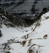 Snow Climbing High on the Route
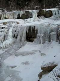 The Pillars Mid-Route
This route starts with several hundred feet of streambed climbing. This part can be a steep rocky hike, a low angle ice scramble or a snow climb.
As you reach the headwall of the route, you'll come to a nice pitch of easy ice slabs. Above here will be several options to overcome the steepest part of the route. There are a couple steep water ice pillars that can be tackled directly, or avoided on the right or left where you'll find steep snow (and trees on the left).
Above here several more pitches of snow lead to the top of the gully where there are several options to top out, all look of similar technical difficulty.
Either bushwhack through steep snow and firs straight East to join the AT, or descend the route. It is about 3 miles down the AT back to the highway, where it is a short hike back north to the parking lot.
Essential Gear
- Crampons- Ice axe; may take an ice tool or two tools if you prefer
- 60 meter dry rope(s) - longer ropes will give you more opportunities in finding belays if you want to belay. Consider 2 ropes and rapping the gully descent.
- Light ice rack + a couple pieces of small rock gear up to 1.5"
- Several Slings
- Helmet
- Full winter clothing (you are in the White Mountains here and the weather can be pretty mean, even if the route is moderate).
Obviously, this can be scaled down if you elect to not rope up.
External Links
Youtube Video - Skiing Landslide GullyPics from a Ski of Lower Landslide
Great Photo at neice.com
Area Conditions Report Page - neclimbs.com