|
|
Route |
|---|---|
|
|
4.65813°N / 75.32982°W |
|
|
Basic Snow/Glacier Climb |
|
|
A few days |
|
|
PD |
|
|
Introduction and Route Diagram
This is the recommended route up Nevado Tolima from Las Latas. La Caneleta has become very dangerous since the glacier has receded. As an added bonus, the route descibed on this page also avoids the crevassed areas.
Approach
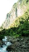
Most climbers will start the approach to the trailhead in Bogotá. From Bogotá, you must travel to Ibague. Ibague can be reached by bus or plane from Bogotá. We took the Pullman bus, for about $7 a person in 1998-1999. From Ibague, you can either hire a vehicle to El Silencio or take public transport. If you are in a group (5-6 people), it is economical to hire a vehicle (about $25 in 1998-1999); if alone or with only another person, you will probably want to use public transport. To use public transport, locate the local bus (rather than long distance) station in Ibague. It is (or was) at Carrera 1, Numero 12-13. Take a bus to La Juntas (one or two hours, in 1998-1999, it cost about $1). From there, the only transport to El Silencio is the milk truck (lechero). It currently leaves La Juntas at 10:30 AM, and cost $2-3. The climb starts at El Silencio.Note: No matter if you take public transport, or hire a vehicle, make sure to check out the incredibly impressive gorge on the left side of the road between Las Juntas and El Silencio. This is one of the most incredible gorges I've seen in the world, so don't miss it!
Route Description
Once at El Silenio, sign the climbing register at the entrance gate. El Silencio is at 2580 meters (8464 feet). Follow the trail through the forest and pretty grasslands and in to the glacial gorge. This gorge is very spectacular and the trail follows it to El Rancho. There are several stream crossings along the way. El Rancho (2690 meters/8825 feet) has some really nice hot springs. There is a very basic rufugio here as well. I would consider soaking in them on the way back from the mountain, rather than on the way to the mountain, because they are so nice that you may want to soak for a few days and never leave to climb the mountain!The trail splits three ways at El Rancho. The path on the left heads to a nice waterfall. The trail straight ahead leads to other peak in Los Nevados as well as the heavily crevassed and difficult West Face of Nevado Tolima. The tail you want is the one heading to the right. The trail climbs very steeply to Las Cuevas, and can be very slippery in places. It is quite strenuous The trail passes through a really nice jungle/rainforest (another pic) and has fine views of the spectacular gorge below. You will pass another nice waterfall along the way.
Las Cuevas (3800 meters/12,467 feet) has a very basic refugio, but a tent is recommended. The refugio sleeps six, and was dilapidated but usable. It may not last much longer, so I would certainly bring a tent. There is water available here.
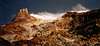
From Las Cuevas, the trail heads uphill through the Paramo and to Las Latas. There are also places to camp between Las Cuevas and Las Latas, but there is no water in the dry season between these two campsites. There are nice views of Tolima along the way, assuming the weather is good. Las Latas is a rather rocky campsite (another photo) at about 4600 meters (15,091 feet), complete with a large wooden cross. There are fine views of Nevado Tolima from Las Latas, and of the valleys below (another photo). There is water available here, but it comes from glacier melt and after the stream flows through volcanic ash. Its the worst tasting water I've had in my life! You may want to pack some up from Las Cuevas, or strain it before filtering it. The water is better in the moring before the afternoon sun speeds up melting, and is just tolerable.
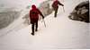
From Las Latas, headed directly up to the right through the rock ribs (see route diagram) and towards the summit of Tolima. There is some steep scrambling of up to class-3 in difficulty. At a convienient place, cross over the black lava ridge to the gully just to the east of the lava ridge. Follow this gully all the way to the snowline/glacier. Continue up the snow/glacier to the crater rim and to the summit. The glacier isn't that steep (up to 35-40 degrees at its steepest part). By using this route, you should avoid crossing any crevasses. Crevasses exist on almost any other route. Take a rope just in case however. Use caution in the gully above Las Latas, and its better just to stay completely away. It's best to stay on one side or the other and on high ground while following the gully. The reason for this is rockfall danger. Some huge bus sized rocks come crashing down from the volcanic plug known as Cerro Negro, and some of them make it into this gully. Don't even try to pass under Cerro Negro to try and reach the summit of Tolima because a few climbers have been killed by rockfall here. The route described above is fairly easy (for a glaciated mountain) and fairly safe.
For acclimatization, four days are recommended for this route (one day to Las Cuevas, one day to Las Latas, one day to summit and back to Las Cuevas, and one day out). If you are already acclimatized, you could do it in three long days. You may want to spen an additional night at El Rancho so you can soak in those great hot springs.