Background
I had decided the Thursday before that I would make a winter conditions solo attempt on a 4,000 meter peak – a first for me.
Mt. Sniktau seemed to fit the bill. An added bonus would be a high trailhead (
Loveland Pass) that would allow me to be home in time to catch the NCAA tournament games that afternoon and evening.
I left my home in northern Colorado Springs at about 5:00am and headed to
Loveland Pass. My goal was to pass through the Denver area before the ski day trippers hit Interstate 70. I arrived at
Loveland Pass a few minutes before 7:00am to find a few other vehicles already parked – it looked like a small party was heading over to attempt
Grizzly Peak. I headed out from the parking lot a few minutes after 7:00am with a thin cloud layer covering the entire area.
The Trip
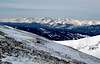
![Views to south from Mt. Sniktau ridge]() Torrey's Peak and Grizzly Peak
Torrey's Peak and Grizzly Peak
The
Continental Divide extends from the
Loveland Pass parking lot at 11,992’ up
the ridge east-north-east to
Point 12,915’ along the Clear Creek County/ Summit
County Line. This ridge is the first portion of the
Mt. Sniktau southwest ridge
route. The snow on the ridge was relatively compacted with a few areas here and
there where I either punched through 6”-12” or encountered loose powder. I could
see a party of three ahead of me on the ridge but it became apparent they were
angling south towards
Grizzly Peak –I now knew I would likely have
Mt. Sniktau all
to myself. Once I was above any avalanche danger I skirted northwest of
Point 12,915’ and attained the
Mt. Sniktau spur ridge that heads north from the
Continental Divide ridge.
![Late March conditions of the Mt. Sniktau ridge]() Mt. Sniktau SW Ridge
Mt. Sniktau SW Ridge
Leaving the
Continental Divide behind I first descended slightly to the Point 12,915
/ Point 13,152’
saddle at about 12,800’. At this time I first started hearing the
avalanche crews at either A-basin or Loveland ski areas setting off their concussion
grenades. Once I had figured out what these noises were I began the gradual climb
to
Point 13,152’. On the climb to the summit of
Point 13,152’ it sunk in just how great
the views were from the ridge – particularly the
view of
Torrey’s Peak.
![Upper Clear Creek Valley from Mt. Sniktau]() Upper Clear Creek Valley and I-70
Upper Clear Creek Valley and I-70
I then turned my attention to
Mt. Sniktau. It was only about a half-mile away but I
would first have to loose nearly 150’ to the Point 13,152’/ Mt. Sniktau
saddle. The
cornice on the east side of this saddle was quite impressive in the early morning light.
It didn’t take long to reach the summit of
Mt. Sniktau but it did take a while for me to
leave – I enjoyed soaking in all of the phenomenal views and having them all to
myself. I found myself wondering if the drivers looking up from
Interstate 70 below
realized that someone was looking back down at them – probably not. They were too
busy speeding to the Summit and Eagle County ski areas.
![Mosquito and Tenmile Range from Mt. Sniktau]() Mosquitos & Tenmile Ranges
Mosquitos & Tenmile Ranges
After over a half-hour on the summit I headed back to
Loveland Pass. Upon arriving it
was clear that my decision to get an early start was a good one. Between the
backcountry skiers/ boarders and all of the tourists stopping to take pictures
the place was a zoo. Vehicles coming and going, tractor-trailers avoiding the
Eisenhower tunnel, swearing, radios…….you get the point. I had expected this so
it didn’t lessen the great experience I had just had.
Overall this was a great introduction to winter conditions. I had a great time –
although it would have been nice to share the experience. The key is to hit this one
early to beat all of the day tripper traffic.


Comments
Post a Comment