Synopsis
Amy and I did a long hike in the Latir Peak Wilderness (
Carson National Forest) starting from Cabresto Lake (~9160'). This wilderness is located in the northern
Sangre de Cristo Mountains of New Mexico. We hiked up the
Lake Fork Trail (#82) and then turned left onto the Bull Creek Trail (#85), doing the Latir Loop in the clockwise direction. Along the way, we strayed from the main loop several times to summit 6 ranked 12ers: PT 12170 ("
Bull Creek Peak"), PT 12456 ("
Cabresto Sur Este"),
Cabresto Pk (12448'),
Venado Pk (12734'),
Virsylvia Pk (12594'), and
Latir Pk (12708'). (We had to re-climb Venado after climbing Virsylvia.) We returned to the TH via Heart Lake, making for an ~18 mile RT with ~5700' of elevation climbed. Our car-to-car time was 10.5 hours, and we had perfect weather for the long committing day above treeline. We encountered nothing exceeding class 1+ terrain.
Directions to Cabresto Lake
From the town of Questa, NM, go east on Route 38. In ~0.7 miles, turn left onto Kiowa Rd (signed for Cabresto Lake) which eventually becomes Forest Service Road 138. One mile later, at a T-intersection and stop sign, turn right (again following sign for Cabresto Lake). Another 2 miles later, the road transitions to gravel and you arrive at another stop sign. Turn right and continue on FS 138 for 3.4 miles to a sign and left turn for FS 134A and Cabresto Lake. Hi-clearance 4WD is recommended for FS 134A. After 2.2 miles on FS 134A you will reach a good sized parking lot and Cabresto Lake. The TH as well as picnic tables and outhouses are located here.
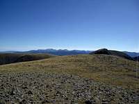
Heading up, and the first three summits
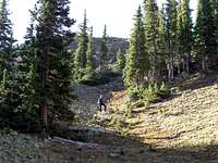
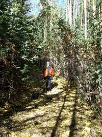
We started out at 7am and hiked up the Lake Fork Trail along the creek, which was flowing pretty well for so late in the season. There were many small healthy side streams coming down across the trail. After about an hour, we reached the junction with the Bull Creek Trail, and we decided to take it so that we would climb the later higher peaks after we had already consumed most of our food and water. The Bull Creek Trail was easy to follow. Even where it got faint through a meadow, there were cairns marking the way. We took a small side path down to a pretty unnamed lake around 11340'. Around 11600', I started looking for a good way up to the 11860' saddle between PTs 12170 and 12456. We took a steep grassy slope that avoided the steep talus and reached the saddle around 9:20am. From there it was an easy walk to the summit of PT 12170 ("Bull Creek Peak"), a ranked NM 12er. This was the first of 6 planned summits for the day, so there was still a long way to go!
![Unnamed lake at 11340]() Unnamed lake at ~11340'. Unnamed lake at ~11340'. | ![Heading toward saddle between PTs 12456 and 12170]() Amy heading up steep grass toward the saddle. Amy heading up steep grass toward the saddle. | ![Hiking toward PT 12170 with PT 12456 behind]() Hiking toward "Bull Creek Pk". Hiking toward "Bull Creek Pk". |
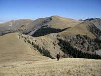
We returned to the saddle and then started the ~600' climb to PT 12456 ("Cabresto Sur Este"). This was also easy steep hiking with just a few short sections of scree. We made it to the summit about 1/2 hour after leaving the summit of PT 12170. There was a good view of Pinabete Peak, with its NE-facing avy chute, from here. From here it was a pleasant stroll down to a saddle and then over to Cabresto Pk (12448'), which we reached around 10:35am. We could see down the Rito del Medio drainage to Questa Dome, a premier granite feature known for its climbing routes, and also Ute Mountain to the NW rising above the plains. To the north there were good views of Venado and Virsylvia, our next two summit objectives. We signed the summit register (entries dating from 1967!) and took a short snack break. Just as we were about to depart, a solo climber from Taos reached the summit from the NE ridge. He had climbed up from the Rito del Medio drainage. We chatted for a bit and then departed around 11am for the long stroll over to Venado Pk (12734'), the highest peak in the Latir Peak Wilderness.
![Latirs]() Hiking toward "Cabresto Sur Este." Hiking toward "Cabresto Sur Este." | ![Pinabete Peak]() Pinabete Pk from "Cabresto Sur Este." Pinabete Pk from "Cabresto Sur Este." | ![Amy on Cabresto Pk]() Amy on Cabresto Pk summit. Amy on Cabresto Pk summit. |
Venado, Virsylvia, and Latir Peaks
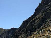
From the saddle between Cabresto and Venado Pks, we picked up a trail and skirted above the highest trees and headed toward the upper reaches of Virgin Canyon. We left the trail shortly before it reached the next saddle and climbed the grass slopes directly toward the summit of Venado Pk, which we reached at 12:08pm. We signed the register and continued NW toward Virsylvia. The out-and-back excursion to Virsylvia is about 1.5 miles RT with ~900' of total climbing required. It looked a bit daunting after we'd been at it for over 5 hours with ~4400' under our belts already. We saw some mountain goats on the steep cliffs near the saddle between the two peaks. We skirted below some minor highpoints and reached the summit of Virsylvia around 12:45pm. There were spectacular colors from the fall foliage on some south facing slopes just to the north, and we could see the Culebra and Blanca groups to the north. Again, we didn't linger long and headed back toward Venado, not looking forward to the ~500' climb from the saddle, where we stopped for a short snack break. We got back to the summit of Venado at 1:30pm, our second time on its summit that day.
![Cabresto Pk]() Cabresto Pk from upper Virgin Canyon. Cabresto Pk from upper Virgin Canyon. | ![Mountain goat]() Mountain goat near Venado/Virsylvia saddle. Mountain goat near Venado/Virsylvia saddle. | ![Amy reclimbing Venado Pk]() Re-climbing Venado Pk. Re-climbing Venado Pk. |
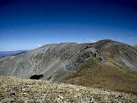
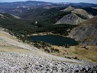
From there we headed down Venado's NE ridge, passed another solo climber heading up, and picked up a trail heading toward the Latir Mesa. Soon we saw the other solo climber whom we had seen on Cabresto Peak. He had climbed Latir and now was headed toward Venado before heading down the Rito del Medio drainage to his car. It was a short walk over to Latir Peak, which had two high points vying to be the true summit. It was about 2:30pm now. We (and my altimeter) actually think the southern one is slightly higher than the northern one, which is recognized as the true summit. From the Latir Peak ridge, we could see down to the beautiful Latir Lakes, each one occupying a slightly higher forested bench. The highest lake (also the largest) is at 11893'.
![Latir Pk from Venado Pk]() Latir Pk from just below Venado Pk. Latir Pk from just below Venado Pk. | ![Looking south from Latir Pk]() Looking south from Latir Pk. Looking south from Latir Pk. | ![Latir Lakes]() Latir Lakes. Latir Lakes. |
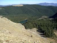
The long hike out
We headed SE along the fantastic Latir Mesa and had another short snack break at a rock pile windshelter at one of the minor highpoints on the Latir Mesa. And then we followed widely spaced cairns (no real trail) to reach a spot where a trail materializes and zigzags down toward Heart Lake.
![Heart Lake from Latir Mesa]() Heart Lake from the edge of Latir Mesa. Heart Lake from the edge of Latir Mesa. | ![Trail to Latir Mesa]() Looking back up toward the rim of Latir Mesa. Looking back up toward the rim of Latir Mesa. |
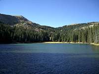
We made a quick descent down the good trail and stopped briefly just before 4pm to get a view of Heart Lake. From here, we had nothing but reaching the TH and then a nice meal at
Joseph's Table in Taos in mind. It was about 5 miles back, and it took us 1.5 hours. Along the way were some beautiful fall colors, with fallen yellow aspen leaves carpeting the trail and the forest floor.
![Heart Lake]() Heart Lake. Heart Lake. | ![Heart Lake trail covered by leaves]() Fallen yellow aspen leaves carpeting the trail. Fallen yellow aspen leaves carpeting the trail. |
This was probably our last big remote outing for awhile since Amy is now in her 7th month of pregnancy. It was a worthy day to close a chapter in our lives, and we look forward to starting a new one as a party of three.
Time splits
7am: departed Cabresto Lake TH
9:25am: summit of 12170 ("Bull Creek Pk")
10:05am: summit of 12456 ("Cabresto Sur Este")
10:35am: summit of Cabresto Pk (12448')
12:08pm: summit of Venado Pk (12734')
12:45pm: summit of Virsylvia Pk (12594')
1:30pm: summit of Venado Pk (again)
2:35pm: summit of Latir Pk (12708')
3:55pm: shore of Heart Lake
5:30pm: back at TH
References and external links
1. Kai Huschke,
50 Hikes in Northern New Mexico (Countryman Press, Woodstock, VT, 2007), pp. 151-156.
2. Topo map, "Latir Peak and Wheeler Peak Wildernesses," U.S. Forest Service.
3.
Lists of John
4.
Carson National Forest


Comments
Post a Comment