-
 2546 Hits
-
 0% Score
-
 0 Votes
|
|
Route |
|---|---|
|
|
41.10865°N / 111.90596°W |
|
|
Download GPX » View Route on Map |
|
|
Hiking |
|
|
Spring |
|
|
Most of a day |
|
|
Class 3 |
|
|
Northern shortcut to Great Western Trail
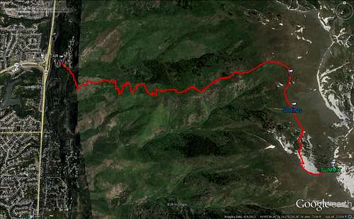
Set GPS to 3195 Layton Ridge Drive, Layton UT. Layton Ridge Drive sort of goes up the mountain where route 193 ends. However, you have to access Layton Ridge drive via route 89 by turning off (east) south of 193. Head up Layton Ridge Drive and drive through two switchbacks as you head up the hill. As you round the second 180 degree turn, look to the left. There are two parking areas labeled "BST parking Layton City". Walk downhill on Layton Ridge Drive a short distance and look for the labeled trailhead on the south side of the road. Note - don't park at the cul-de-sac way up the hill unless you want to risk a ticket.
Start hiking up the trail. In about 5 minutes, you will come to a big intersection with a fire road. Hike to the metal gate crossing the fire road. In a very short distance, you will cross a creek. Immediately look to the left for a trail. This is right after the creek. Really look for this trail right after the creek because you don't want to miss it. There are other trails going up after which eventually connect, but you will waste time if you go on one of these routes.
Go up this trail. In 0.5 miles you will come to a four-way intersection. Look for the cairn pile downhill. This is your turning point. You want to turn left and head uphill. If you miss this turn and continue straight on the trail, you will still intersect the GW trail eventually- but you will add some unnecessary mileage.
At 1.09 miles from the parking area, you will hit the Great Western Trail. Turn left and follow the Great Western trail. Yes, turn left. It is confusing- trust me. You may want to set a waypoint on your GPS or leave a marker here. It is easy to miss this turn when you are coming back down the trail (returning).
There is a spring 5.5 miles from the parking area. Turn left at the campsite with the iron stove. (See Great Western Trail directions for all trail details).
From the parking area to the top of Layton Peak 5.5 miles, 3942' elevation gain. Our max elevation showed 9552' and we did it in 3 hrs 32 minutes of moving time.