Introduction
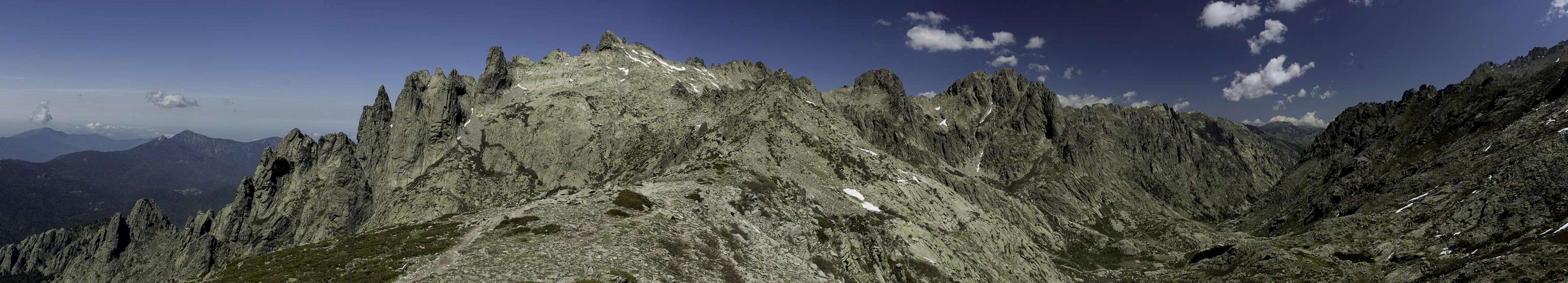
![Lac de Capitello]() The granite scenery at Lac de Capitello The granite scenery at Lac de Capitello |
! They call it
L'Ile de la Beauté - the island of eauty. They call it
La Montagne dans la Mèr - the mounntain in the sea. The names are fully deserved: there are some 50 2000ers on the island and if you happen to visit the island in late spring or early summer you'llbe impressed by the natural scenery. Most of the island is made up from granite - either the solid grey one you also get elsewhere, or the red tafoni granite, which forms grotesque sculptures with holes, windows, caves and overhangs. Sometimes you'll find both forms very close to each other but usually you'ge to
Porto on the west coast or
Bavella in the south to admire
Tafonis. And go to the high mountains of
Haute Corse for the rock solid grey granite.
It certainly might be disputed but to me the heart of
Corsica beats in its centre in and around
Corte. The town used to be the island's capital during independance and most locals still feel strongly in favour of the town. It lies close to the northern mountains of
Haute Corse and thus is a perfect place to start your endeavours. To the west of
Corte two narrow valley lead into the mountains,
Gorges de Tavignano in the north and
Gorges de la Restonica in the south. Both are wonderful hiking grounds but
La Restonica offers more than hiking.
![Gorge de la Restonica]() Looking out of Gorges de la Restonica during the ascent to Lac de Melo
Looking out of Gorges de la Restonica during the ascent to Lac de Melo is roughly 15km long and can be driven by car. In the lower part near
Pont de Timozzo you can either hike up to the
Plateau d'Alzo a large plain used by shepherds or you can hike up the
Timozzo Valley to
Lavu del'Oriente and
Monte Rotondo, the island's second highest mountain. Or - for a small fee - you can drive towards the end of the valley at
Bergerie de Grotelle Where lots of climbing options await you. As well as the popular hikes to two glacier carved lakes:
Lac de Melo and
Lac de Capitello.
What to do on day four?
![Pic Lombarduccio]() Pic Lombarduccio seen from the south
Pic Lombarduccio seen from the south
During our first stay on
Corsica we had stayed on the west coast near the
Golfe de Lisgia and had realized that the most interesting parts of the island required drives of several hours along long and (especially) winding roads. Thus in 2012 we decided to move a bit closer and spend two weeks in
Corte in the northern centre of the island. We had rented what we thought was a holiday apartment but what turned out to be a residential condo in a high rise. The appartment was ok but cut and furnished in a modern French taste, which sometimes can be hard to digest for us regular German folks. No chairs - only bar stools and - more irritating - no door to close the bathroom. It was the fourth day of the vacation and we had managed to getting used to this.
The first three days had been spent in lower
Restonica Gorge with the hike to the
Plateau d'Alzo and the class IV climb to
Le Forcelle (an assortment of granite towers), with a hike among the
Aiguiles de Bavella where we imagine d to marvel at
Tafoni structures in the fog and a hike / climb to
Punta dell'Oriente just across
Col de Vizzavona. Again we had admired the wonderful granite and were ready for more. Judith suggested to return to
Gorge de la Restoniza to hike to
Lac de Melo and
Lac de Capitello, a must-see according to our guidebook.
I was lukewarm about this very popular hike and expected masses of people but it would be a Wednesday, so better go there now and not later over a weekend. In addition we lived only 15km to the north-east of the trailhead so we would be among the first to arrive there and might be able to outrun any contenders. The tour was estimated to take 3h 30min but there were additional options with several passes and an additional lake or two. And
Punta alle Porte might turn out to become our summit to bag at 2313m.
The start ...
![At Lac de Melo]() At Lac de Melo
At Lac de Melo
... turned out as expected. We got up early and started from Corte around 6:30 driving the narrow Restonica road in less than half an hour. A piece of bad luck placed us behind a van, which slowly moved through the valley only to stop and block the road. It turned out to be the vehicle with which the fees were collected. So we also got to be the first to pay a few Euros that day. A few km later we rolled into the large parking lot at
Bergerie de Grotelle where we parked beside the only other car - a camper with two American climbers who just got themselves ready for their own outing.
If you start from the parking lot you feel dwarved by Pic Lombarduccio high above your head. While hiking farther into the valley the views of the multi-pillared mountain change dramatically. We hiked along the young
Rivière de la Restoniza which forms a lot of wonderful cascades jumping down from the lakes above. Some way inside the valley we had to decide between two parallel trails to
Lac de Melo. We decided on the more difficult (accordding to our guidebook) "via ferrata", which in the end turned out to be the easier one of the two routes. There were a few ladders to negotiate terrain steps, maybe a cable or two but we quickly and easily gained height and quite suddenly came upon our first lake of the day:
Lac de Melo.
They say it is "a gem", a
dark eye among the granite peaks and with the backdrop of
Poine de Sept Lacs,
El Capitello and
Pic de Lombarduccio it truly is a wonderful place to stay. We were the second ones to arrive here (a group of three had passed us on the normal route) and we quickly passed through to get to higher terrain.
Lac de Campitello
![Capitello and Pic Lombarduccio]() Punta Capitello and Pic Lombarduccio
Punta Capitello and Pic Lombarduccio
If you hike from
Lac de Melo to
Lac de Capitello you have to negotiate a huge granite step. There is a steep but very well marked trail which leaves no option to go wrong. You quickly rise above
Lac de Melo which from this angle reveals itself to be almost circular. Beyond, Corsica's second highest mountain,
Monte Rotondo starts to loom.
The higher you get, the more impressive the view and finally you reach the top of the step, the overflow of
Lac de Campitello. If
Lac de Melo impresses by its tranquility,
Lac de Campitello impresses by its surroundings. Directly beyond the lake vertical walls with overhangs rise for several hundred metres. A remote climbers paradise!
Pointe des Sept Lacs,
Capu a I Sorbi,
Il Capitello and
Pic Lombarduccio form the cirque above the lake - a huge circle of granite!
It was only 9:00 so we had to decide how to proceed from here. Descending back to base was out of the question. We decided to scramble up to a col on the southern ridge to trekking trail
GR20. We thought it was
Brêche de Capitello but it turned out to be an unnamed saddle. There was still snow in the steep couloir which led to the col and more than once we wondered whether we should be going on without any proper equipment. I stamped down steps into the snow so that Judith could follow easily and we blocked out the thought of slipping here.
![Lac de Capitellu]() Lac de Capitello
Lac de Capitello
Finally we managed to get to the col. While here on the south side the snow had melted, there was still plenty of the stuff on the wind protected path towards
Punta alle Porte so that we decided not to risk the ascent. This decision was supported when we saw GR20 trekkers descend from the mountain through a snow filled chimney only protected by a loose chain. No risk today.
The traverse
![Lac de Capitello with Capu a Chiostru (2295m) and Pic Lombarduccio (2261m)]() Looking down the ascent couloir to Lac di Capitello
Looking down the ascent couloir to Lac di Capitello
Instead we decided to traverse left onto
GR20 east. But before we started we admired the views in front of us. Looking south we saw several ridgelines which culminate in the pyramid of
Monte d’Oro. Looking north, there’s the couloir we scrambled up with
Pic Lombarduccio above
Lac di Capitello. To the west we saw the leaning towers of
Le Casete while to the east our own section of
GR20 headed towards
Punta Muzzella.
So we turned left and descended a ridge towards the saddle
Bocca a Soglia where another route from
Lac de Melo joined. Still it was early, 10:45, and another detour had to be planned. The guidebook suggested a variation, following
GR20 further on towards another lake,
Lac de Rinoso, and also towards two saddles,
Col de Rinoso and
Bocca Muzzella. From there an alternative descent would take us back to our car at
Bergerie de Grotelle.
So we set out on the path, first heading north-east and while we did we realized we had to cross half a dozen hanging snowfields. Doubtlessly there had been other people before us but not today. Warm weather the day before had cancelled any footsteps so that we had to decide for the best route ourselves. Some of the traverses were long and steep and we took deep breaths after we had managed to get to the far side of the last of these snowfields.
Looking across the upper Restonica Basin |
Now the path turned fully east and we had to scramble up a steep, rocky slope to
Col de Rinoso. Clouds started to roll in and the higher we got the darker they turned. We completely missed
Lac de Rinoso and paraded up towards
Bocca Muzzella across a large but flat-angled snowfield. Up in the saddle it was windy and cold as clouds had obscured the sun. Still we decided to have lunch but the wind drained out the last of our body heat. Though we had intended to climb either
A Maniccia to the north or
Punta Muzzella to the south after a look at the darkening sky we quickly agreed to rather go back down.
Racing the clouds
![Punta Muzzella]() Punta Muzzella seen from Bocca Muzzella
Punta Muzzella seen from Bocca Muzzella
Now, fleeing a storm is never fun and with descending clouds views got worse and worse. We either would have the snowfields to traverse or descend an unknown valley towards our trailhead. We opted for the known path with the only unknown stretch between
Bocca a Soglia and
Lac di Melo – a popular hike and mist likely easy to find and least difficult.
Descending, we finally spotted
Lac de Rinoso in a nook behind
Col de Rinoso. The lake was partly covered with ice which nicely fitted the doomsday weather pattern above. The wonderful pillars to the west above
Lac de Melo and
Lac de Capitello started to vanish in clouds and everything looked and felt icily cold.
Lac de Melo – still on full display – turned even darker than before – a mysterious dark blue.
Beyond
Col de Rinoso the clouds somewhat lifted while temperatures rose back to sweatshirt level. We traversed the snowfields – much easier on the return since we had our own footprints to guide us. Back in
Bocca a Soglia the sun reappeared as we started the long descent to
Lac de Melo. We met some freely grazing horses, said hello but passed them without stopping to caress them, like we would have done usually. A narrow canyon and some large granite slabs later we ended up on the western shore of the lake, where we decided to take a break and eat our last food – two apples.
Scavengers
![Chaffinch]() Chaffinch (Fringilla coelebs), stretching to get some of the apple booty
Chaffinch (Fringilla coelebs), stretching to get some of the apple booty
Being used to hiking in the Alps we are familiar with the local feathered scavengers, the
Alpine Choughs, which you find close to any popular summit or near any mountain hut. Still we were surprised to see them here as well, flash-mobbing us and our apples on the shore of
Lac de Melo. Never the patient types they hated to wait and inspected all of our equipment which we had placed around our resting place. After finding nothing we received longing stares and a flurry of wings after throwing them our apple cores. Favourite of mine among them was a
chaffinch, which stretched to look whether he should join the fray. He didn’t and I felt bad that he didn’t get any booty.
Now the last part of the journey started – the much trodden trail towards
Bergerie de Grotelle. So far we had only met an occasional hiker but now a steady flow of tourists came the other way. The path turned out to be very rocky and we would have been glad if we had decided on the ferrata (we came up on) instead. Still, we had some good views, there was a wonderfully veiled waterfall coming down the
Vallee de Rinoso (our intended route) and finally we ended up at the parking lot at
Bergerie de Grotelle. 15km by car and we were back in our apartment, taking showers in an open bathroom ...
Comments
No comments posted yet.


 The granite scenery at Lac de Capitello