Got up in my cousin’s apartment in Tehran (elevation 1450 m, 4800 ft) at 1:00 a.m. I had gone to bed at 11:00 p.m. and had not fallen asleep. Called my guide Salim, packed my last items, went outside and sat in the alley under the trees. There was a near full moon.
Salim and the driver came at 2:30 a.m. We took the freeways to eastern Tehran. Around 20-30 years ago, they began planting pine trees on some of the otherwise barren hills around the city of Tehran to create a green belt around it. Many of these growths have now turned into mature forests that help clean Tehran’s polluted air. A few months ago I had read (in an Iranian newspaper on the internet) about a plan to build a freeway through one of these forested areas. This had enraged the Iranian environmentalists. Unfortunately, the only other alternative was to tear down entire blocks of homes in a neighborhood. In the end, of course, the trees lost and construction began through the forest (Click here to see pictures and read (in Farsi) a report by an environmental NGO whose website I often visit).
We then got on the Haraz Road which connects Tehran to the town of Amol on the Caspian Sea Coast via the Haraz River Valley. From eastern Tehran, the road crossed a series of hills, then headed east on a plain at the southern base of the Alborz Mountains to reach the town of Ab-Ali (2050 m, 6700 ft, and 60 Km from Tehran). When I was a child, only a few villages existed between Tehran and Ab-Ali. It now appeared that urban sprawl had turned many of those areas into suburbs of Tehran and the road from Tehran to Ab-Ali had been changed to a 4 lane divided highway.
After Ab-Ali, the road made a series of turns and twists going up the slopes of the Alborz Mountains to reach the bottom of the Ab-Ali ski area (2450 m, 8000 ft). Ab-Ali is a small old ski resort. One of the first mechanical ski lifts in Iran was installed here in 1953 (click to read about the history of skiing in Iran). Low elevation (and therefore a shorter ski season) along with low vertical drop (250 m, 800 ft) make Ab-Ali a less desirable ski area than the much larger and higher Dizin ski resort. I still remember from my childhood how the more affluent skiers in Tehran used to snub Ab-Ali which was frequented by people of lower socioeconomic backgrounds, some of whom used to go to the area to just slide down its nearby slopes in nothing more than old tires.
The road then continued up the mountains until it reached the Emamzadeh Hashem Pass (2700 m, 8850 ft). The slopes had no trees and were only covered by small thorny plants. Historically, this portion of the road has been very susceptible to winter avalanches so a long tunnel is being constructed at the base of the mountain to bypass the high pass. Apparently, during the construction, an underground water table found its way into the tunnel causing a massive flood (click here to see pictures and read (in Farsi) the critical report by the same environmental NGO that I mentioned earlier).
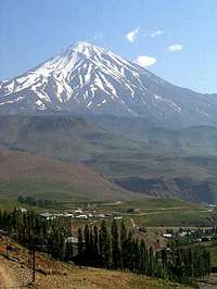
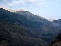
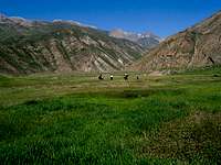
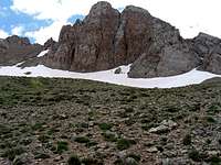
I could see the nearby mountains in the bright moonlight. I knew that Mt. Damavand (5671 m, 18606 ft) would soon come into view and was very eager to see it in the light of the moon but it soon became cloudy.
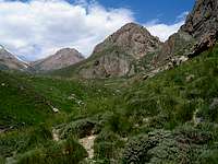
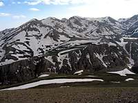
North of the pass, the road made a series of switchbacks and went down to a fairly open area where Mt. Damavand comes into view. At that hour, however, it was dark and cloudy so nothing could be seen.
Damavand from Haraz Rd
We then reached the village of Poloor (2200 m, 7200 ft) which sits on the banks of the Haraz River at the foot of Mt. Damavand. After Poloor, the road followed the Haraz River at the bottom of the Haraz Valley which is a deep canyon that penetrates into the heart of the Alborz Mountains right next to Mt. Damavand. As we went north, the elevation steadily dropped (100 Km after Poloor the road reaches zero elevation on the Caspian Sea Coast).
It began to lighten up. The roaring Haraz River was always in good view. On both sides of the river, steep mountain slopes went up into the clouds. They were doing maintenance work in one of the longer tunnels on the road (midnight to 6 a.m.) so the traffic was one way in the tunnel and we ended up waiting there for approximately15 minutes. That gave me a chance to get out and stretch a little.
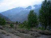
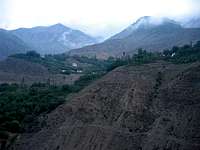
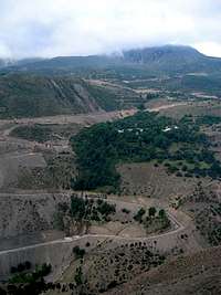
Rd to Nomar
Rd to Nomar
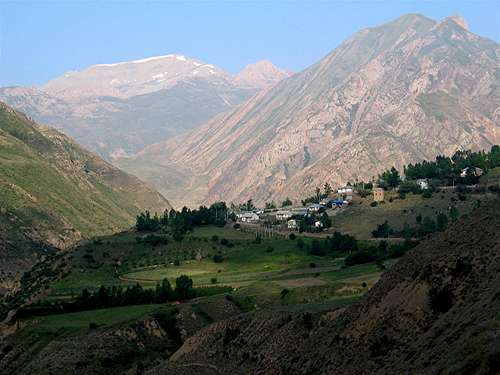
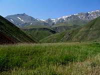
Near the village of Panjab (850 m, 2800 ft), we turned west onto a dirt road that went up a side valley known as the Nomarestagh River Valley. The road was wide and smooth but went up in elevation fairly steeply. Bushes and small trees came to cover most of the slopes. These were not part of the Caspian Rain Forests but seemed to be an independent ecosystem that thrived in that valley. The mountains went up to merge into the clouds. I could see groups of houses and lone houses scattered all over the slopes. I was sure that some of the higher houses must have had superb views of the surrounding mountains. From far away, it was hard to say if the lone houses far up the slopes belonged to the locals or were expensive vacation homes.
Rd to Nomar
Rd to Nomar
The driver was a talkative and funny guy who seemed to be in his upper 40s. He had served in the Iran-Iraq war (1980-88) and had volunteered for dangerous duties such as digging trenches on the front lines. Back in the 1980s, I too had been of draft age but I had left Iran because I was not (and am still not) a fighter. When I actually come face to face with a person like that driver, however, I realize how much I owe them. If it had not been for the bravery of people like that driver who fought against all odds, I now would probably not have been able to take climbing trips to Iran (to say the least!). It is very ironic that when Saddam Hussein attacked Iran, many countries continued to give him aid and support even when he used chemical weapons against Iranian soldiers. These same countries now seem to be very concerned about the spread of the “Weapons of Mass Destruction”. Try to explain that to a person like that driver!
On the road, we saw a sign for a shrine with a long Arabic (and not Farsi) name: “Emamzadeh Abdulmanaaf”. (Emam refers to the 12 descendents of the prophet who are considered saints/leaders in Shia Islam. “Emamzadeh” refers to a descendent of an Emam). The driver was making sarcastic comments about religion in general and these Emamzadehs which seem to appear all over Iran. He said: “You want me to believe that 1400 years ago when the Arabs invaded the Persian Empire and brought Islam to Iran, one of their descendents found his way from (what is now) Saudi Arabia all the way to this remote valley and died in this very same spot creating this Emamzadeh?” He was saying that many of these Emamzadehs might have been ancient Zoroastrian holy sites which have now become Islamic. He then went on to say how in the old days charlatans used to go to villages playing magical tricks and convincing the locals that they had divine powers. When they died, their graves became holy sites.
Otagh Posht
The clouds began to break and the first rays of the morning sun came to shine on the tops of the mountains that towered above us. To the south, I could see a couple of impressive peaks that had no snow but were covered with forest and green grass. These must have been the “Otagh Posht” Peaks (3500 m, 11500 ft). The village of Nomar, which is the last village up the valley, soon came into view. I could see the Kaoon Peak (4075 m, 13369 ft) rising behind the village.
Otagh Posht
Nomar Village & Kaoon Peak
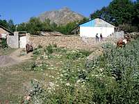
After 25 Km on the dirt road, we reached Nomar (2150 m, 7000 ft) at 7:00 a.m. The village seemed to house no more than two to three dozen families, most of whom stayed there only in summer. My guide Salim had earlier contacted a local man and arranged to rent a mule to carry our load to where we hoped to set our first camp. The area has many 4000 m peaks, some of which I hoped to climb during the next few days. When planning this trip months ago, I had looked at my maps again and again and had come up with various itineraries which allowed us to climb as many peaks as possible with minimal number of changes in the location of overnight camping spots. Nothing seemed to have worked to my satisfaction. In the end, I had decided to just get in the area and do whatever I could (My 2004 and 2005 plans had been much more extensive than what I had actually been able to achieve). For the first day, the plan was to go to the Lehra Pass (3650 m, 12000 ft) or maybe even beyond it.
We were supposed to meet the mule-man at 8:00 a.m. We parked in an “empty lot” near the village grocery store and had breakfast in our vehicle. Salim asked the guy in the grocery store to call the mule-man. I thought it was quite interesting that both the grocer and the mule-man had cell phones. That was a perfect example of a “leap in technology”. I am sure the village had gone from no phone at all directly to cell phones.
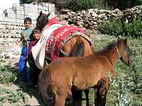
After a while, a boy who was riding a horse came and told us to follow him to the mule-man’s house. We drove up an alley to reach the mule-man’s house and then waited there for him to come. The mule-man had three sons and they seemed to be happy to have their pictures taken by me. The mule-man finally came and invited us into his house but we told him we better get going. He then brought Salim, the driver and I each a glass of hot milk. I thought that it was quite possible that the milk was not a commercially pasteurized product. Maybe he had milked his own cow. Was I to drink it and risk getting diarrhea on the first day of the trip? How was I to politely get myself out of that situation? As I was brain storming to come up with an answer, I heard Salim say that he had lactose intolerance and could not drink milk. I thought “You Bastard” you stole what I wanted to say. In the end I drank the milk and nothing happened.
The mule-man brought two mules (or horses or whatever they were). One of them had a very cute foal which came with us all the way to the Lehra Saddle. The foal was afraid of me and did not allow me to pet it. Watching that young and playful creature running around the beautiful meadows was a real pleasure. I noticed how he kept venturing away from his mother to explore the world on his own. He would then suddenly realize that he had fallen far behind his mother and would frantically run toward her.
A two-track seemed to continue up the valley a few more kilometers beyond the village so the driver agreed to drive us a little further. The mule-man got in the vehicle with us and two of his sons rode the mules in front of us. The valley had a wide and flat bottom. The river ran on one side of the valley floor. We soon reached a good size ditch on the two-track. Salim kept telling the driver that his four wheel drive vehicle could easily overcome the ditch but the driver was hesitant to go further saying if he was to get stuck there, we would probably abandon him and it would cost him lots of money to have someone tow his vehicle back to a town where it could be fixed. In the end, he found another way around the ditch.
From two-track
After around 3.5 Km, we reached the end of the two-track (2250 m, 7350 ft) where there was a foot bridge over the river. We loaded our backpacks onto the mules and said good bye to the driver and the mule-man’s younger son. The older son (who was probably 10-12 years old) came with us. We crossed the bridge and started our hike at 8:30 a.m. The boy rode his mule all the way to the top. The mule-man rode his mule intermittently and offered Salim & I to ride it too but we said that we preferred to hike. I stopped often to film and take pictures so I kept falling behind.
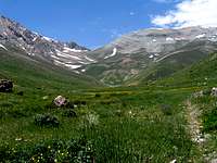
We got on an established trail that followed the stream uphill. Green thorny plants and flowers covered the ground. To the south, a series of snowy peaks had come into view. These were the Lehra Peaks. My map shows (depending on how you count them) 5 peaks (3 prominent ones) all in the 3800 m range. I had considered bagging one of the Lehra Peaks on the first day of the trip if time allowed.
Lehra Peak
Daryook Plain
Daryook Plain
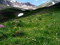
We soon reached the Daryook Plain (2350 m, 7700 ft) which was a fairly large and flat plain that was covered with tall green grass. Streams from at least three different valleys seemed to converge at that spot. There were a couple of day hikers there (we did not see anyone after that). We then had to cross the stream again but there were no bridges so we rode the mules.
View of Daryook
Lehra Peaks
Lehra Peaks
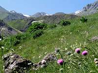
The trail went up a slope and we got a good view of the Daryook Plain. The vegetation became very lush. Green grasses and flowers carpeted the slopes. We were probably in an environmentally protected zone where sheep herding was not allowed. I was wondering if that was the reason why it became so lush. The Lehra Peaks were now appearing as rocky summits that rose above the green slopes. I was absolutely loving it there. It looked so beautiful. We also went by a couple of mineral warm water springs that smelled mildly of sulfur.
Lehra Peaks
Lehra Peaks
Chehel Cheshmeh
Chehel Cheshmeh
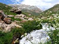
At around 2800 m (9200 ft), we reached a place called “Chehel Cheshmeh” (Forty Springs) where water ran down the slopes over a large area. That was of course a very inviting place. We sat at a dry spot that was otherwise surrounded by running water and had a snack.
Chehel Cheshmeh (Forty Springs)
Kaoon
Siyaroo
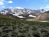
As we moved on, the Kaoon Peak (4075 m, 13369 ft) came into view again. A couple of rocky peaks appeared to the northeast of Kaoon. One of them must have been the Siyaroo Peak (3783 m, 12411 ft).
Kaoon
Kaoon
Lehra Peak
Lehra Peak
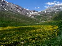
We then reached an open flat area (2900 m, 9500 ft) that was covered with green grass and large fields of beautiful yellow flowers. The Lehra Saddle (3650 m, 12000 ft) which sits between the Kaoon and Lehra Peaks finally came to view there. I was getting tired and we still had 2500 vertical feet to climb.
Lehra Pass
Siyaroo from flat area
Lehra Pass
We traveled the length of the flat area and then followed the trail up the slopes toward the Lehra Saddle. A type of plant known as “Gavan”, which I have seen in many parts of the Alborz Mountains, appeared all over the place. The plant is dome-like, is a few feet in diameter and might be a foot or so tall. It is basically a half ball of thorns but its surface is covered by flowers that are usually purple.
Gavan
Lehra Peaks
Lehra Peak & Pass
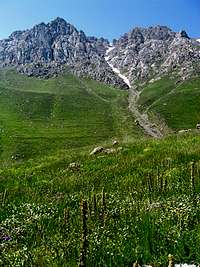
Patches of snow began to appear at an elevation of 3000 m (9850 ft). It became partly to mostly cloudy. The rocky and snowy north faces of the Lehra Peaks could be seen to our south. Kaoon Peak, which was just a big pile of gravel, loomed to our northwest. The lush green grasses were gradually replaced by thorny plants. We sat at a place a few hundred vertical meters below the Lehra Saddle and had lunch (cans of tuna fish and chicken with bread and tea). These locals seem to be addicted to tea. The mule-man was saying he would not feel refreshed unless he drank at least two glasses of tea.
North face of Lehra Peaks
I was eager to reach the Lehra Saddle and see Dokhaharan (4338 m, 14232 ft) and the other high peaks of the area. On summitpost.org, there had been an abandoned page about the twin summits of the Dokhaharan Peaks. The page contained only a few sentences and four pictures, one of which was supposedly taken from the Lehra Saddle (I have now adopted that page and added much more info and many more pictures to it). Those were the only pictures that I had ever seen of Dokhaharan and their nearby Mountains.
Once I reached the Lehra Saddle (3650 m, 12000 ft), the view that I had been so anxiously awaiting finally appeared. I was just awe-stricken by the rugged majesty of the scene. To the southwest, I could see the Dokhaharan, Chapakro & Takhte Khers Peaks while directly to the south, the five peaks known as the Sesang Peaks were in good view. Huge amounts of snow seemed to still remain on those mountains. I stood there taking pictures, filming and just absorbing it all.
Dokhaharan
Sesang
I suddenly realized that Salim and the mule-man who were a few hundred meters in front of me were yelling for me. I told them to keep going but they wanted to talk to me so I had to cut my sight seeing short and walk down to where they were. At the time we were thinking of hiking down the other side of the Lehra Pass to set up our base camp on the banks of the Sesang River (3470 m, 11400 ft) but the mule-man was saying that the saddle was the perfect spot for us to camp because we were right at the base of the Kaoon & Lehra Peaks. I thought that he was probably right. If we camped there, we could easily bag one of the Lehra peaks on the same day (It was 1:45 p.m. and we had come 14.5 Km, 9 miles from the Nomar village).
Salim & I took our backpack off of the mules and said goodbye to the mule-man and his son. We then set our tent at a spot under the Lehra saddle where there was a stream of water that came from underneath a big patch of snow. From our camp, we only had views of some of the eastern Sesang Peaks, took a nap from 3 to 4 p.m.
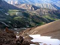
We then decided to head for the Lehra Peaks which are basically high points that rise on the crest of a ridgeline that eventually connects to Mt. Damavand’s northwestern flank. I would classify only three of those high points as “individual summits”. West to east, these are: Point 3890 m, Point 3894 m & Point 3886 m. Earlier today, we had seen their rocky/snowy and difficult northern slopes. From the saddle, however, it seemed like we could access their very easy southern slopes. None of them were in view from the saddle.
We left our camp at 4:20 p.m. and headed east on easy dirt slopes until the first Lehra Peak (3890 m, 12762 ft) came to view. A huge rocky tower seemed to form the summit of the mountain. As we went higher, it became apparent that a spot to the east of the tower was a little higher than the top of the tower so we did not even go to the tower. Reached the summit at 5:05 p.m. (1.25 Km, 0.8 miles from the saddle).
Lehra Tower
Lehra Tower
On the summit, the nearly perfect cone of Mt. Damavand (5671 m, 18606 ft) came into view to the southeast. The very top of it was hidden in clouds. The distance between us and the summit of Damavand was only 13.3 Km (8.3 miles). Damavand, of course, is the absolute king of the Alborz Mountains. Its great size and height dwarf all the other mountains around it. Compared to Damavand, everything else appears as mere hills in the background. I came to see Damavand again and again during the next 5 days and I kept thinking of it as the guardian of that little piece of paradise that is also known as the Alborz Mountains.
Mt. Damavand from the summit of the first Lehra Peak
Vararoo
Valley we hiked
I now had better views of the 4000 m peaks of the Dokhaharan Massif to the south and southwest. I could also see the Vararoo Peak (3994 m, 13104 m) to the south. I had considered including Vararoo in our climbing plans over the next few days but it now became apparent that it was too far away. To the north, steep rocky slopes went down to the bottom of the green valley that we had hiked up earlier today.
Sesang
Dokhaharan
We then hiked back. Just before reaching the tent, the sun came out and I got great views of the Sesang Peaks in the yellow rays of the evening sun.
Sesang
I sat outside the tent and began to write my diary while Salim went inside to cook. Once the sun went down, it became very cold so I went inside. We ate soup and a spaghetti meal and soon went to sleep.
Parents refers to a larger category under which an object falls. For example, theAconcagua mountain page has the 'Aconcagua Group' and the 'Seven Summits' asparents and is a parent itself to many routes, photos, and Trip Reports.


Comments
Post a Comment