
-
 25148 Hits
-
 89.77% Score
-
 30 Votes
|
|
Area/Range |
|---|---|
|
|
35.29551°N / 24.06487°E |
|
|
Hiking, Mountaineering, Scrambling, Canyoneering, Skiing |
|
|
Spring, Summer, Fall, Winter |
|
|
8048 ft / 2453 m |
|
|
1 - Overview
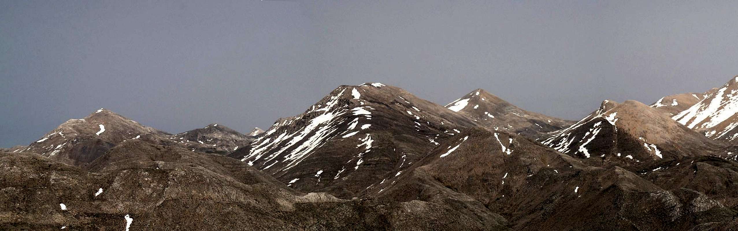
 The Levka Ori seen across the Samaria Gorge from Volakias The Levka Ori seen across the Samaria Gorge from Volakias |
Λευκα Ορη – the Greek name for Crete’s largest mountain range can be transcribed in several ways. On most maps you will find Lefka Ori, sometimes Levka Ori or if Greeks transcribe it, they will say Leuka Ori. I opted for the middle ground for the name of this page on SP.
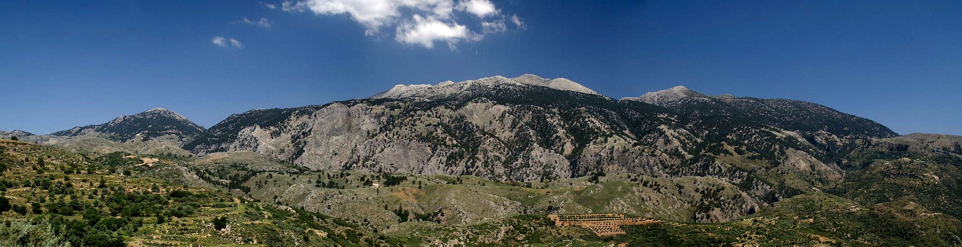
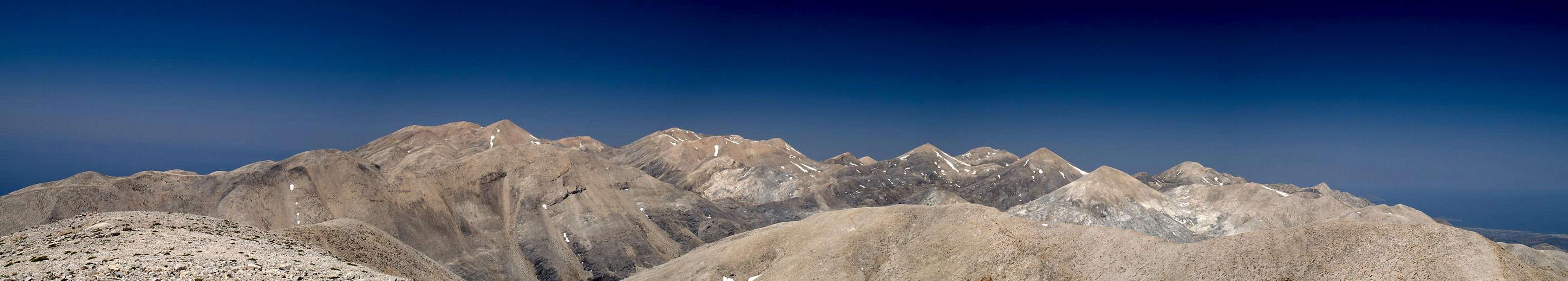
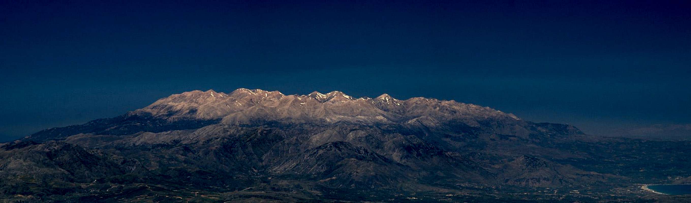
Levka Ori – the White Mountains – named like that since the range is the only one on Crete to be covered with snow until late in spring. Moreover, being built from pale limestone, its peaks glisten in the hot Cretan sun even without a snow cover so that the name is really well deserved. The range is Crete’s largest one, one of the largest mountain ranges of Greece. To some accounts it has 54 summits above 2000m. However, there are much less named peaks that tall, most of which have multiple summits thus accounting for the big number. The highest mountain is Pachnes / Παχνες, at 2453m Crete’s second highest one, only beaten by Psiloritis / Ψηλορειτις, which reaches (2456m).
Crete’s mountain ranges are made up from limestone – and the Levka Ori are no exception. Everywhere on the island you find karst phenomena and again – in the Levka Ori they are most pronounced. Wind and rain have leveled much of the range so that summits appear like rounded hills presiding above large high plateaus. The whole area has been hollowed out from the inside and you’ll finde lots of caves, crevices, ravines and gorges in the area. The most common phenomenon is the doline, a collapse zone, where underground structures have given way to crater-like depressions, which nowadays are filled with vegetation of all kinds. The most impressive of these are the orphrys orchids and the endemic arum species.
Probably the White Mountains are best known for their gorges – the four most important ones cut through the range in its southern part. The Samaria Gorge draws most visitors, being the longest of European Gorges and a natural line of separation between the main part of the range and its western subgroup. The Aradena Gorge runs though the far south of the Levka Ori while the Agia Irini Gorge and the Imbros Gorges serve as western and eastern boundaries of the range. The southern boundary is the coast (with very impressive cliffs) while the northern one is a bit fuzzy and can be envisioned as the last line of habitations surrounding the range.
Two branches of the European long distance trekking trail E4 run through the range. The coastal one follows the shoreline and can be extreme in terms of heat, difficulty and exposure. The Alpine one, which wriggles its way between the high summits is unmarked in its central part, which poses serious problems in orientation. Like any karst mountain range the Levka Ori are somewhat “featureless”, with no significant landmarks to guide you. Crossing the plateaus can mean large detours because of crevices which cut through the ground or dolines opening up before you. On lower elevations thorny bushes add to the problem. Crossing the Levka Ori in foggy conditions definitely is no good idea unless you are equipped with good guiding material and/or a GPS receiver.
2 - Levka Ori on SP
Though a compact range the Levka Ori have been divided into five subgroup for submission here at SP. All groups are identified by their location and by the highest summit within their boundaries. The westernmost group, beyond the Samaria Gorge, sometimes is not considered part of the range anymore but since it contains two of the most visited 2000ers of the area which can serve as examples for the karst phenomena of the whole range they have been added here.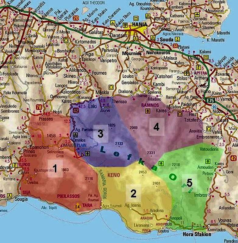
 |
Together with the map posted above the following list is supposed to give you an overview over the mountains submitted to SP and where you will find them on this page. The map is interactive so that clicking the numbers will direct you to the section on this page. The list below contains mountains and canyons. The canyons are located at the back end of the listing for the respective range.
- Western Range (Volakias)
- Main Range (Pachnes)
- North-Western Range (Melindaou)
- Northern Range (Grias Soros)
- Eastern Range (Kastro)
3 - Western Range (Volakias)
 |
The western range is separated from the bulk of the Levka Ori by the Samaria Gorge and the Omalos Plain. Sometimes not considered part of the White Mountains due to this separation it nevertheless shows the same karst phenomena as the central Levka Ori. Two of its summits, Gingilos and Volakias, are the most visited mountains on Crete, thanks to the perfect location of the Xyloskalo trailhead beneath their east slopes. The subgroup spreads between the Agia Irini and Samaria Gorges and possesses several villages on its outskirts. The E4-branch, which runs along the coast between the two gorges is the most extreme part of the whole treck.
- Kaimeni / Καυμενη (1398m)
- Tourli / Τουρλι (1458m)
- Psilafi / Ψηλαφι (1984m)
![]()
- Gingilos / Γινγιλος (2080m)
![]()
- Volakias / Βολακιας (2116m)
![]()
- Katsaromoura / Κατσαρομουρα (1694m)
- Toumba / Τουπα (1139m)
- Ochro / Οχρο (807m)


4 - Main Range (Pachnes)
 |
In its north the Samaria Gorge bends eastward in a wide circle, separating the southern from the northern summits of the Levka Ori Range. The southern ones are the highest summits of the whole range, Pachnes and Troharis, located close to each other in the middle of the range. Reaching them is far from easy, mainly because of the very long access routes, making them some of the least climbed mountains on the whole island.
To the south of these main summits the subgroup quickly drops towards a large plateau, the fertile plain of Anopolis, Aradena and Agios Ioanis. It stretches foar towards the sea, where it suddenly drops almost vertically towards the small bays and beaches of southern Crete. Not surprisingly this part of the range also is cut through by profound canyons, the Aradena Gorge being the longest and most impressive one.
- Kouvara / Κουβαρα (1186m)
- Psiristra / Ψιριστρα (1766m)
- Korifi Avlimonakou / Κορυφη Αβλιμονακου (1858m)
- Papakefala / Παπακεφαλα (1020m)
- Zaranokefala / Ζαρανοκεφαλα (2140m)
- Pachnes / Παχνες (2453m)
![]()
- Troharis / Τροχαρης (2410m)
![]()
- Kerdokefala / Κερδοκεφαλα (1720m)


5 - North-Western Range (Melindaou)
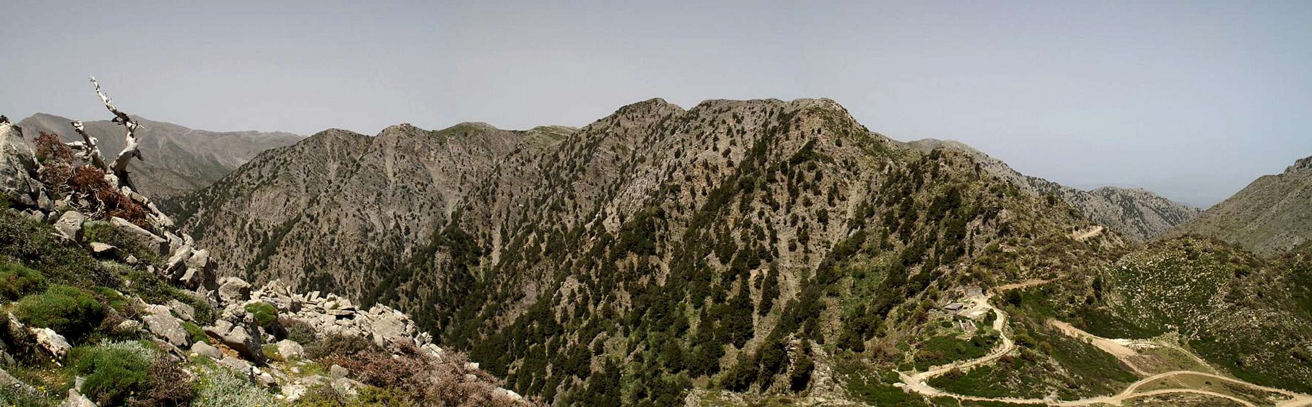 |
The north-western subgroup, the highest mountain of which is Melindaou at its south-eastern end, is the “tamest” one of the subgroups. Except for its highpoint and the neighbouring mountains, which all tower above the eastern branch of the Samaria Gorge, the summits are lower and covered with dense vegetation. Apart from the ridge Psari – Mavri – Melindaou only Koukoule is climbed regularly since there is a direct trail from Omalos to the Kallergi Hut. Still the subgroup is visited rather often since the Alpine branch of E4 runs straight through it.
- Koukoule / Κουκουλε (1629m)
- Psari / Πσαρη (1810m)
- Mavri / Μαυρι (1828m)
- Melindaou / Μελινταου (2133m)
![]()
- Kaloros / Καλορος (1925m)
- Agavani / Αγαβανη (1552m)
- Konstantinou / Κωνσταντινου (809m)
- Xirokefalia / Ξηροκεφαλια (860m)

6 - Northern Range (Grias Soros)
 |
Formed like a triangular wedge the northern subrange probably is the most photographed one of the Levka Ori. It can be seen from almost anywhere on the northern coast of the island where the tourist towns and beaches are located. Its summits are often covered with snow late into spring, which serves as an explanation for the range’s name – the White mountain. However, the highest summits, Agio Pnevma and Grias Soros, are hidden from view behind the lower Mavri and Spahi. Again, the alpine branch of E4 runs through this subgroup and it is here where the trail is unmarked and orientation is most difficult. Moreover the cols beneath the highest summits are very lonesome and only the Katsiveli Hut can serve as a base.
On the group’s northern outskirts the Volakias Hut can be found which serves as base for climbs of the northernmost 2000ers Spahi and Mavri. However, these paths are also unmarked and orientation is difficult as well.
- Xerakokefala / Ξερακοκεφαλα (1238m)
- Anginares / Αγγιναρες (1115m)
- Halassi / Χαλασσι (1221m)
![]()
- Mavri / Μαυρη (2069m)
- Spahi / Σπαδι (2046m)
![]()
- Ornio / Ορνιο (2153m)
![]()
- Agio Pnevma / Αγιο Πνευμα (2254m)
- Grias Soros / Γριας Σωρος (2331m)
![]()
- Anthropolithos / Ανθροπολιθος (2096m)
- Lines / Λινες (2093m)


7 - Eastern Range (Kastro)
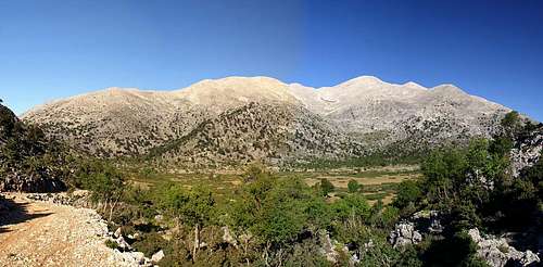 The eastern range of the Levka Ori with Kastro to the right
The eastern part of the Levka Ori reaches down to civilization again. While its highest mountains, Kastro and Kakovoli are still located very far inside the range its southern and eastern parts are either inhabited or used for farming, goat and sheep grazing by the local shepherds. Here you can find some of the most beautiful high plateaus, all circular, surrounded by hills and covered with all kinds of greenery. In the south the range drops into the Lybian Sea near Chora Skafion, the “capital” of Crete’s south.
- Korda / Κορδα (1612m)
- Agriokefala / Αγριοκεφαλα (1478m)
- Agrimokefala / Αγριμοκεφαλα (1340m)
- Kastro / Καστρο (2218m)
![]()
- Kakovoli / Κακοβολι (2214m)
![]()
- Skoutsio Korifi / Σκουτσιο Κορυφη (1893m)
![]()
- Vigla / Βιγλα (1415m)
- Kastri / Καστρι (846m)


8 - Getting There
 |
8.1 - By Plane
There are two international airports, both in the north of the island. One is at Chania in the west, the other is at Heraklion in the centre.
8.2 - By Ferry
There are myriads of ferries in Greece, which connect the many islands of the country. Consequently there are many ferry harbours and Crete is no exception. However, most of the smaller harbours only cater for transportation to the other islands while the major lines to the mainland are reserved to two harbours, Souda near Chania and Heraklion. Both serve connections to Peiraias and Thessaloniki.
8.3 - By Bus and Car
All of the villages on the outskirts of the Levka Ori can be reached by bus. However, except for the lines which connect Chania with Omalos and Chora Skafion bus transfer is rather sporadic. The Omalos and Chora Skafion lines run about once an hour and many tour organizers also serve the two villages.
With a car you can reach all trailheads in all villages though, especially in the north, roads signs can be a bit confusing. Again, the roads to Omalos and Chora Skafion serve as the best itineraries as well as the western route from Chania to Sougia.
9 - Accommodation
You can quite easily find hotel rooms and apartments everywhere on the coasts. All European travel companies offer accommodation so a visit to your nearest travel office will find you some. In the mountain villages there always are inns and if everything fails you can pitch a tent.9.1 - Camping
There are abundant campgrounds along the coast and on many of the beaches you can pitch your tent. The tourist beaches in the north and the beaches in the vicinity of tourist towns are mostly off-limits but there is many a cove which you can use. In the mountains you will often find cattle (goat and sheep) fences which you should respect. There is many a green meadow in one of the plains but you should be aware that you’ll be woken up by goats. Again, in the vicinity of villages, rather ask the locals if you can use their land. Any place within the natural park Fysikon Parko Samarias, which encompasses the Samaria Gorge and the surrounding mountains, is off limits for camping
9.2 - Mountian Huts
There are four mountain huts in the Levka Ori, maintained by EOS, the Greek Alpine Club. The ones close to habitation are generally open most times of the year while the remote ones can be closed as late as May.
| Refuge / Hut | Height |
| Kallergi Hut | 1600m |
| Volika Hut | 1260m |
| Katsiveli Hut | 1970m |
| Tavri Hut | 1200m |
10 - Red Tape
 Ophrys Mammosa
There is not much red tape on Crete. There is a National Park, Fysikon Parko Samarias, which encompasses the Samaria Gorge and its surroundings where over night accommodation is strictly forbidden (even in the huts in the area). You will find that you have to pay entry fees for the most popular locations (again the Samaria Gorge but also the Agia Irini Gorge) but apart from that there are no / few limitations.
On the other hand there are a lot of rare endemic flowers on the island. I'm not aware of any restrictions concerning them but you might take care not to pluck any of them. The mountains around the Samaria gorge are home to the last specimen of the Golden Eagle and Bearded Vulture, which you might see soar above the gorge. Their eyries are located in the steep faces of the mountains above the upper Samaria Gorge but rather far away from the regular climbing routes. Still, take care not to disturb them, especially in the first half of the year when thy raise their little ones.
More information on the park Fysikon Parko Samarias
11 - Weather Conditions
The weather sites on the web only carry information for the cities on the north coast, which are 2000m lower than the mountains of the Levka Ori. Consequently temperatures will be lower by some 15° C on the summits. Also, especially in winter and spring, the White Mountains are covered in clouds while the coast is clear. On a day like this don't venture in the range - orientation is difficult enough without clouds. The nearest weather link I could find was at Souda near Chania on the north coast of the island, some 60km to the north:12 - Maps & Books
There are quite a number of maps and books out there, which deal with the island of Crete and naturally I don’t know them all. This is the list of maps and books which I used and I appreciate it very much if you can add to it12.1 - Maps
Unfortunately there are no topographic maps of Crete. The best maps I could find are scaled 1:100000 and contain the main hiking routes on the island. In one case the map showed wrong paths and roads (exchanged them) but in general they were quite useful.
- Kreta / Crete / ΚΡΗΤΗ Western Part
Touring Map
1:100000
Harms Verlag
ISBN: 3-927468-16-9
12.2 - Books
Since there are no good topographical maps of Crete you should take care to get a good guidebook. The ones I used have good tour suggestions though the descriptions often are somewhat shortish. In one case the maps were wrong but since the above map also showed wrong paths (as well as other maps I saw later) I attribute this to a general problem with the cartography of this specific area. Moreover, the books were issued in 2002 and thus paths might have changed meanwhile. The books are available in German and English.
- Crete: The White Mountains - A Walker's and Trekker's Guidebook
Lorraine Wilson
Cicerone Press
ISBN: 9781852842987
- Kreta West / Crete West
Gert Hirner / Jakob Murböck (translation: Gill Round)
Rother Verlag
ISBN:
3-7633-4221-4 (German)
3-7633-4803-9 (English)
afariz - May 21, 2009 9:10 am - Voted 9/10
correctionDears, in the part Ares&Ranges, Levka Ori, there is in an article describing this mountains. In the part 8.3 - By Bus and Car - there is a mistake in last words of this paragraph. You write there about connection in western part of Crete (leading to trailheads into mountains) from the Chania city to Souda, but I think, the name of Souda is not right, I suppose, the right name should be Sougia!! Souda is actualy the harbour of Chania and doesn't have any context with the subject of this part (8.3) of the article, whereas Sougia is the village on the southern coast to which runs a road roughly following western borders of Levka Ori.
Gangolf Haub - May 23, 2009 12:27 pm - Hasn't voted
Re: correctionOf course you are right. And I even started one of my hikes in Sougia! Not sure how this could have happened :o)