
-
 8292 Hits
-
 81.18% Score
-
 13 Votes
|
|
Mountain/Rock |
|---|---|
|
|
35.32759°N / 23.98212°E |
|
|
Hiking, Scrambling |
|
|
Spring, Summer, Fall, Winter |
|
|
5938 ft / 1810 m |
|
|
Overview
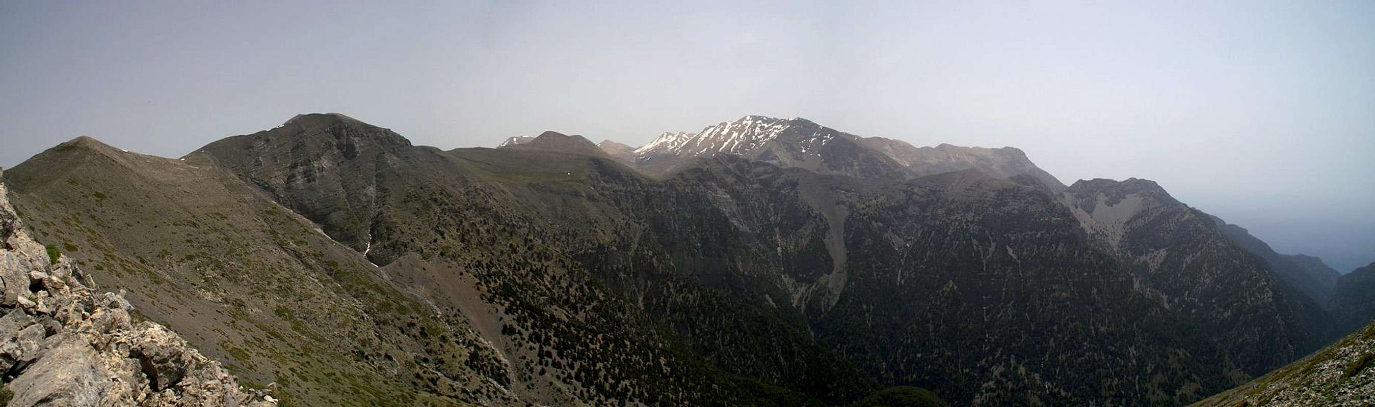
 Volakias and Gingilos seen across the Psari Summit Volakias and Gingilos seen across the Psari Summit |
Psari - or Πσαρη as it is known in its original language, is one of the mountains of the Melindaou subgroup of the Levka Ori Range, the White Mountains of Crete. It is the first summit of a long ridge, which culminates in Melindao, the highest mountain of its subgroup. Also, Psari is located high above Europe's longest canyon, the Samaria Gorge, which takes a bend eastward at its base. Like the other mountains in the southern Melindaou group, it is located quite central in the mountain range and thus offers great views all around.
Psari is a typical Karst mountain. Made up from limestone, you find lots of cave-like depressions on its slopes and the south face, which towers above the upper Samaria Gorge, offers lots of roosting places for the few golden eagles and bearded vultures which remain in the range. One of the two Melindaou ascent routes run across the Psari summit. It climbs the Psari north ridge, an exposed scramble directly above the Samaria Gorge with great views towards Gingilos and Volakias in the west. In the lower part of this route a cave has collapsed recently to create a new doline, which is pretty hard to negotiate. The remainder of the route is simply very steep until you reach the summit.
The best trailhead for the climb of Psari is Xyloskalo, the entry to the Samaria Gorge. From there you can reach the base of the mountain by a long and winding dirt road, which is only used by local shepherds. Except for the wintertime the central Levka Ori Range is very dry, with only few plants surviving the early days of spring. High on the ridge, near the Psari summit, however, you can find spring crocuses until late in May. On the lower slopes you can find the endemic Allium subhirsutum, a beautiful species of wild leek/garlic.
Summit View
  |
Getting There
 High plateau underneath Koukoule
The most reasonable starting point for a climb of Psahi is Xyloskalo, the parking lot at the entry to the Samaria Gorge. The lot is located at the southern end of the Omalos plain and can be easily reached from Chania, the main city of the north-west of Crete. The road leads through Fournes, from which it climbs to Lakki and onwards to Omalos. At all parts of the road signs lead to either Omalos or to the Samaria Gorge.
Red Tape
 Allium subhirsutum
Psari is located in a pocket just outside the northern boundary of the natural park Fysikon Parko Samarias, which encompasses the Samaria Gorge and the surrounding mountains. Staying in the park over night is not allowed and you have to return to the hotels in Omalos or to the Kallergi hut on the eastern side of the gorge. The mountains around the Samaria Gorge are home to the last specimen of the Golden Eagle and Bearded Vulture, which you might see soar above the gorge. Their eyries are located in the steep faces of the mountains above the upper Samaria Gorge but rather far away from the regular climbing routes. Still, take care not to disturb them, especially in the first half of the year when thy raise their little ones.
More information on the park
Accommodation
 Kallergi Hut
You can quite easily find hotel rooms and apartments everywhere on the coasts. All European travel companies offer accommodation so a visit to your nearest travel office will find you some. The closest possible hotel is at Omalos, a one hour hike from Xyloskalo, the trailhead. On the eastern side of the gorge there is the Kallergi Hut, also about an hour away from Xyloskalo and on the route to Psari.
Weather Conditions
The weather sites on the web only carry information for the cities on the north coast, which are roughly 2000m lower than the mountain top of Psari. Consequently temperatures will be lower by some 15° C on the summit. Also, especially in winter and spring, the White Mountains are often covered in clouds while the coast is clear. On a day like this don't venture in the range - orientation is difficult enough without clouds. The nearest weather link I could find was at Souda near Chania on the north coast of the island, some 60km to the north:Maps & Books
There are quite a number of maps and books out there, which deal with the island of Crete and naturally I don’t know them all. This is the list of maps and books which I used and I appreciate it very much if you can add to itMaps
Unfortunately there are no topographic maps of Crete. The best map I could find is scaled 1:100000 and contains the main hiking routes on the island. In one case the map showed wrong paths and roads (exchanged them) but in general they were quite useful.
- Kreta / Crete / ΚΡΗΤΗ Western Part
Touring Map
1:100000
Harms Verlag
ISBN: 3-927468-16-9
Books
Since there are no good topographical maps of Crete you should take care to get a good guidebook. The one I used have good tour suggestions though the descriptions often are somewhat shortish.
- Kreta West / Crete West
Gert Hirner / Jakob Murböck (translation: Gill Round)
Rother Verlag
ISBN:
3-7633-4221-4 (German)
3-7633-4803-9 (English)