
|
|
Route |
|---|---|
|
|
34.12250°N / 116.9225°W |
|
|
Hiking |
|
|
Spring |
|
|
Half a day |
|
|
Class 2 |
|
|
Overview
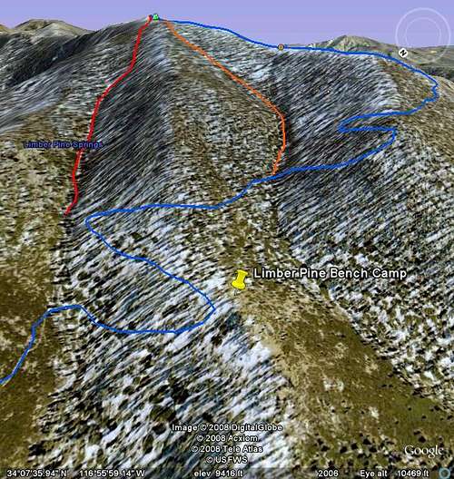
This route follows the same trail as the San Bernardino Peak Trail up to Limber Pine Bench Camp. From here, its off trail. From Limber Pine Bench Camp to San Bernardino Peak its about around 2.5 miles by following the San Bernardino Peak Trail. Roundtrip using this trail, its about 16 miles to the peak and back. However, with the Limber Pine Creek Route, its cuts off a few miles. After reaching Limber Pine Bench Camp, continue until you reach the first switchback. There will be a distinct drainage coming down from the mountain. This is where Limber Pine Spring is at and it is also the drainage for this creek. From here, just head up the drainage towards the peak. At around 10,000ft, the drainage begins loosing its appearance. However, keep heading upwards and eventually, the terrain will gradually begin to level out and San Bernardino Peak will come into viewAlso, there is another variation-
There are two main drainage's that drain the north side of San Bernardino Peak. The first being Limber Pine Drainage and another one that is just south of Limber Pine Drainage. When at Limber Pine Bench camp, when looking up towards the peak, there are to distinct drainage's that appear immediately in front of you. Limber Pine Drainage is the one to the north and the other one is to the south. The second one I will call "the alternate drainage". Both of these drainage's cut off about 4 miles off the regular trail and add some off trail excitement. Each drainage (when taking heading off trail from where the San Bernardino Peak crosses them) are around .60 one way.
Getting There
Getting there is the same as the Agelus Oaks tail head on the main page. The only difference is after Limber Pine Bench Camp.Route Description
There are nothing technical about this two routes. They can be steep in some places however it is still hikable. It would be better for a winter climb as the snow would make it a little easier to climb.Essential Gear
Summer-Boots, map, water (lots of it if there isn't snow on the ground), and common sense.Winter- crampons and an ice axe would come in handy. Snowshoes might be necessary depending upon when you choose to hike this peak. Know the weather and the conditions of the snow. I saw avalanche debris in the drainage so keep that in mind.
Always check with the rangers about current conditions on the peak.
External Links
San Gorgonio Ranger District34701 Mill Creek Rd., Mentone, CA 92359
(909) 794-1123 or fax (909) 794-1125.
San Gorgonio Ranger District