
|
|
Route |
|---|---|
|
|
38.42300°N / 106.225°W |
|
|
hike, scramble |
|
|
Most of a day |
|
|
class 2 |
|
|
Overview
 Pass of the Buffalo
Round trip distance: 9-11 miles
Elevation gain: 3700'
The trail along the Little Cochetopa Creek is lightly used but in fine condition, complete with an excellent wooden bridge to aid crossing well up the creek. It offers a quiet and scenic alternative to the routes departing from Marshall Pass.
Cochetopa is a Ute word which means "pass of the buffalo."
Getting to the Trailhead
From U.S. Highway 50, two miles west of Poncha Springs, turn south onto County Road 210. Drive 5 miles south and west to the Cochetopa Wildlife Management Area. The road is not maintained past that point and the last three miles to trailhead are rough and require a high clearance vehicle.Route Description
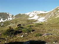
 Landmark on the Little Cochetopa
 North of the Pass
Follow the Little Cochetopa trail west as it crosses the creek twice, the second time on an excellent footbridge. The north side of Mount Ouray passes by in review on your left, offering many photo opportunities. The trail is good until it reaches an old log cabin, and even a ways beyond that. You are headed toward a saddle (either of two saddles, depending on snow conditions) on a north-south ridge that is just over a mile west of Ouray’s summit. Once you reach the ridge, follow it south then east to Ouray’s summit.
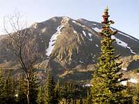 Ouray passing by in review
 West ridge to summit
For your descent, consider a more direct route down the north side of Mount Ouray. Drop off the summit to the north for the first quarter mile. Then follow the ridge line that curves to the northeast. Do not leave the ridge until you reach the first real saddle, at about 11,700’. Any other exit point will subject you to some very steep rock faces, excessive bushwhacking, or both. Descend the large boulder field as far as possible before diving into the trees. Walk straight north through the trees until you reach the creek. If you aim just right you may hit the trail’s lower creek crossing just below the ponds. Otherwise, follow the creek down until you find a suitable crossing, and then join the trail on the other side.
Variation
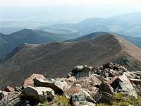 Northeast ridge
For a shorter route (4.5 vs. 5.5 miles one way), leave the Little Cochetopa Trail at the first creek crossing, just before reaching some ponds. This point is about 106.200 degrees west and 10,350' elevation. Bushwhack straight south until you break through the trees onto a rocky slope. Follow this slope up to a saddle in Ouray's northeast ridge. The saddle is at about 11,700'. From this point, follow the northeast ridge as it curves upward toward Ouray's summit.
This route variation is the the descent route described in the Route Description section, above. Recommended for shorter mileage, but is somewhat more difficult to navigate.