
|
|
Route |
|---|---|
|
|
43.59500°N / 72.847°W |
|
|
Hiking |
|
|
Spring, Summer, Fall, Winter |
|
|
Half a day |
|
|
Moderate Hike/Bushwack |
|
|
Overview
This is a varied terrain hike and bushwack to a summit cannister with some beautiful views from the top of the actual peak and the false peak to the east.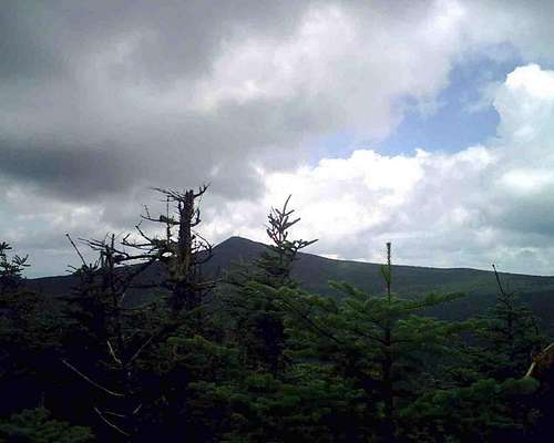 Killington from Mendon Peak
Getting There
Take Route 4 North from Rutland center and turn right onto Wheelerville Road. The turn from Route 4 to Wheelerville is at N43.64813 W72.90346 which is just after the road becomes 2 lanes at 50 MPH. If you make it to Pico you've missed your turn (two turns back). You stay on Wheelerville for close to 4 miles before reaching a sharp bend in the road with a turnoff to the left, this is the trail head. Please note that Wheelerville is an unpaved road. Do not head up the buckland trail (to the left of the parking area), as you pull into the parking area the trail head which consists of a closed gate will be to your right.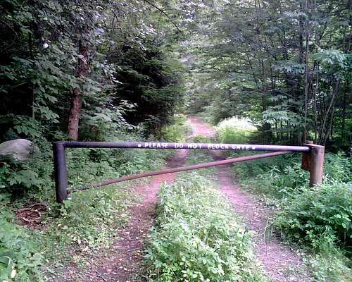 Trail Head
Route Description
 East Peak View
The total route is ~4 miles one way with some twisting in the bushwack. The 1st 3.2 miles are along the logging road. Until you reach the 4th stream crossing the route stays relatively flat gaining only 1000' in 3 miles and meandering back and forth along the Eddy Brook. There are 4 brook crossings (3 across Eddy Brook) and none are particularly difficult though the first may require you to pull off your boots due to water height. Spring melt out may make them more difficult.
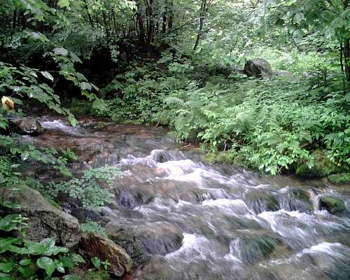 1st Crossing of Eddy Brook
After the 4th stream crossing the pitch of the route changes greatly and over the next mile+ (including bushwack) you will gain an additional 1000' of elevation (450' of gain in the woods during the .5 mile bushwack). There will be 2 hairpin turns back to back in the road with 2 cairns (the second at ~3300' elevation, the first at ~3050'). Turn right into the woods at the second cairn and travel due west (magnetic) which will bring you out onto the eastern false peak where you need to locate a herd path that will lead to the west peak. A peak cannister is attached high on a tree which is ~15' down a well defined side path off the herd path. Return route is reverse of the above. You can also continue up the logging road until it intersects with the LT/AT and touch Killington Peak (returning via buckland trail which drops you at the same parking area).
 2nd Cair and Bushwack Point
Essential Gear
Hiking poles, gators or long pants for the bushwack and appropriate footwear, topo maps, a compass and GPS if you have one (with spare batteries). Think waterproof if it has rained recently, the bushwack will soak you through and protect any electronics you may have in case, dry bag or ziplock as well as maps. For winter consider snowshoes/crampons and an ice axe to self arrest if needed. Due to the bushwack please be sure to have a plan to return, even 30' into the woods makes finding a trail difficult if you're disoriented. Topo and Waypoints
External Links
Some useful material for develping this route can be located at:Good Hike Description
Trip Report
Additional Tips/Notes/Waypoints
Please note that blowdowns, moved cairns, new cairns, weather and changing logging roads make this difficult to describe. Please post any relevant information in summit logs. Also be aware that the herd path described is easy to miss. On my trip between the east and west peak I took the wrong path and wound up at a nice exposed overlook before swinging back in, on the way back I found a remarkably easy, direct herd path. The woods are also strewn with these and they may meander but they do tend towards the peaks so use them and save yourself some effort. Also beware, there were at least a dozen fresh sites of Moose scat on the trail and they will charge you so be careful to make your presence known.One other point, for the return trip be sure that you don't miss the last water crossing, the trail appears to go straight but you need to take what appears to be a side trail to the right and over the brook (your first corssing on the way out).
Valuable waypoints:
Parking/Trail Head N43.61949 W72.87704
cairn1 N43.59728 W72.83682
cairn2 N43.59613 W72.83716
crossing1 N43.60818 W72.85798
crossing2 N43.60645 W72.84999
crossing3 N43.60140 W72.83496
crossing4 N43.59938 W72.83795
House N43.61171 W72.87245
peak cannister N43.59524 W72.84642
 Blow Down