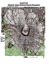
Introduction
If you think you know a mountain by getting to its summit, think again. You can
climb Mt.St.Helens from the south and look into the crater and the lava dome, but hiking the Loowit Trail will give you a new appreciation for the mountain, the landscape that was changed in May 1980, and how it has evolved since the eruption and devastation. This hike involves something over 6000 vertical feet of elevation change, and takes you completely around the mountain.
The trail is named for the Native American name for Mt.St.Helens, a woman in a love triangle legend, the keeper of fire.
Day 1 - Windy Ridge to June Lake
![Mt.St.Helens from the East]() Plains of Abraham near Pumice Butte
Plains of Abraham near Pumice ButteIn late August 2011 eight members of
OSAT circled Mt.St.Helens on the 35-mile Loowit Trail. We circumambulated the volcano in a clockwise direction, beginning at the
Windy Ridge trailhead above Spirit Lake, northeast of the mountain. The mountain was obscured by low overcast as we started out on the first couple of miles of the Truman Trail, which are actually the closed extension of Forest Service Road 99 hugging the southeast side of Windy Ridge.
![Descending Lava Field toward June Lake]() Descending toward June Lake
Descending toward June LakeAnother mile of hiking on the Windy Trail across the barren landscape brought us to the Loowit Trail, which circles Mt.St.Helens at elevations between 4000 and 4900 feet, with excursions down to 3000-3200 feet for our two camps. As we turned south to circle the east side of the mountain, the trail climbed for about a mile to the highest elevation of the entire trip, Windy Pass. From here we could see across the Plains of Abraham, a couple of miles of flat area dominating the east side of the mountain. The hiking was deceptively easy, as this is the only extensive flat section on the entire circuit. The late LaNina-year snows made for late wildflowers, and we were greeted throughout our first day by gardens of flowers. Particularly memorable were several acres in bloom at the base of Pumice Butte, where we had our first lunch at the top of a waterfall dropping into Ape Canyon. Here we also encountered the first five of about twenty hikers we were to encounter during our three-day trip. Two were on bikes, taking the route from Ape Canyon to Windy Ridge via the Abraham Trail that cuts off the steep Windy Pass section of the Loowit. Three hikers were circling the mountain counter-clockwise in two days, so we looked forward to some trail intel from them when we passed the following day.
Happily the skies cleared as we had lunch. The afternoon took us across the Muddy River and Pine Creek Lahars, which gave us our first taste of gully crossings that would be typical on the west and north sides of the mountain. The last of these brought us to the crossing of the Worm Flows lava field, and several miles of up and down hiking with occasional stands of small trees and hanging meadows of wild flowers among the lava. We stopped to rest at a point where both
Mt. Adams and
Mt. Hood were visible, and recounted one of the versions of
Native American legends about the three mountains, known as Pahto, Wy'east, and Loowit. Eventually the trail descended the lava into the old growth forest at the southeast corner of our trip, and we turned off the Loowit for the quick, steep descent to June Lake. Our first camp was between the lake and the lava flows. We were delighted to find the lake fed by a pair of 70 foot waterfalls, one free-falling and one horsetail. We set up our camp, had a hearty dinner, followed by a meeting. As our meeting drew to a close, dark clouds appeared in the west, and we prepared for showers overnight.
Day 2 - June Lake to South Toutle River
![Crossing Lava Field on Loowit Trail]() "Trail" across lava field
"Trail" across lava fieldThe next morning we awoke to overcast skies. I was disappointed to find that the gently ascending side trail on the map from June Lake to Swift Creek is actually a winter ski route across the lava field, with no apparent trail, so we had to hike back up the steep ¼ mile to the Loowit Trail to continue our circuit. The trail quickly re-entered the lower Worm Flows, and at times disappeared entirely among the jumble of rough aa lava, where we were forced to simply boulder hop as we headed from one wood post, plastic pipe pole, or stone cairn to the next. Happily the skies cleared again, this time a bit earlier than the on the first day, and we were soon looking up the familiar south side of St.Helens. A little more than a mile from June Lake we came to the scattered woods along Swift Creek, and passed Chocolate Falls, which were running clear this morning, evidently due to the recent rain. This is where winter and spring climbers often camp. After following the creek for a short section, we left the
Monitor Ridge/Swift Creek climbing route and headed toward the ridge. All of us save one of us, that is! He kept his head down, and stuck to the spring climbing route! Eventually he came to a clearing where he could see far enough ahead that he knew he’d made a wrong turn. In the meantime we had stopped to wait for him, and shortly we all began the 1-1/2-mile, 1000-foot climb up Monitor Ridge through forests and small meadows.
![Blue Lake Wash - Mt. St. Helens west side]() Blue Lake Wash on west side of Mt.St.Helens
Blue Lake Wash on west side of Mt.St.HelensMost of the rest of this day was spent at 4500-5000 feet elevation. After crossing the
summer climbing route (Ptarmigan Trail), we entered the longest and most difficult of the lava flows on the entire trip. Posts, poles, and cairns pointed the way some of the time, but elsewhere conflicting cairns would take part of our group one way and others another. A slip or tumbling loose boulder here with a three-day pack could spell disaster, so we picked our way carefully across the flow. After a mile, we saw we were through the worst of it, and stopped high on the last lava ridge for lunch, looking out to the south where Mt.Hood peeked out among the clouds.
![Northeast shoulder of Mt.St.Helens from South Toutle River Gorge]()
Continuing up the southwest side of St.Helens, the trail crosses thin stands of short timber, occasional meadows with wild flowers, a few lahars and gullies, and one final lava flow. At one point we stopped after descending a couple of hundred feet, thinking perhaps we had missed the trail. Happily the group circling the mountain in the opposite direction showed up, and we realized we were on a major detour trail not shown on the map. The trail continues down the south side of the deep Blue Lake Wash, eventually crossing to the other side where the elevation must be regained to meet up with the original trail. After another mile the path re-enters the eruption impact zone and begins a long 2-mile, 1400 foot descent of Crescent Ridge, initially with views to the north across the South Fork Toutle River to
Johnston Ridge and its Observatory, but also crossing back into old growth forest.
The river crossing provided the most excitement of the day, with one of our number slipping into the swift current. Climbing out of the deep gorge cut by the river through the 1980 mudflow, we made camp above the river and settled down for a night under the stars. NOTE: Although the textual description of the Restricted Zone is "...between South Fork Toutle River and Windy Pass", close examination of
the map indicates the zone does not extend all the way to the river west of where the trail currently crosses the river, which is about 1/4 mile west of the crossing indicated on topo maps.
Day 3 - South Toutle River to Windy Ridge
![Mt.St.Helens from the North in the Blast Zone]() Lunch below The Breach
Lunch below The BreachOur third day was under clear skies, perfect for experiencing the blast zone and surrounding terrain. We began with a hike out of the deep South Toutle River Gorge, crossing a wide open ash slope and re-gaining the 1400 feet lost the previous afternoon. Atop the gorge broad meadows stretch across to Studebaker Ridge. We found plentiful good, clear water in one of the forks of Studebaker Creek, then as we rounded a corner near the north fork of the creek, we were greeted by a herd of 120-150 elk above us. They eventually moved to the top of the ridge, and then down across our trail to the east side of the ridge. Seeing this many animals travelling together was certainly a highlight of the trip we will long remember.
![Loowit Falls]() OSAT team at Loowit Falls
OSAT team at Loowit FallsThe open country now provided a broad vista of the devastation zone to the north of St. Helens, as the trail continued east in a slow descent. Although shrubs and young trees dot the landscape, the lack of forest for 7-8 miles north of the mountain remains as a lesson in the power that was unleashed in May 1980. The landslide debris flow climbs the ridges on the north side of the Toutle, and the logs which have been floating in
Spirit Lake for 30 years washed down from the slopes of
Coldwater Peak and
Mount Margaret leave one wondering at the thought of a 3-mile long lake sloshing hundreds of feet up the opposite hillside when the largest landslide in recorded history rushed into other end of it.
Crossing the still near-lifeless debris flow at the Breach of the crater, we came to our second stream crossing of note. The stream that tumbles over Loowit Falls was flowing swift and strong through its ravine. While most of us searched upstream and down for a crossing point, Erika and Autumn simply changed from boots to sandals and walked across. We ate lunch at a trail intersection below The Breach, before starting back up a mile of trail to the
Loowit Falls side-trail. The falls hide behind cliffs and ridges as the trail gains elevation, with only a portion of the top of the falls visible. We dropped our packs at the upper intersection and hiked up the short trail to the overlook where the falls plunge about 200 feet into a deep gorge less than 2 miles from the crater’s breach. Thinking this was the last highlight of the trip, we headed further east on the trail, only to be surprised by the lush willows and vivid pink Lewis monkey flowers at a spring emerging from the pumice hillside, a mile below its presumed source at the Forsyth Glacier. We took our time filling water bottles for the last time in this little paradise among the barren slopes.
Soon we returned to the intersection where we began our circumambulation, and headed back on the final three miles of trail and road to the Windy Ridge Viewpoint and trailhead. We reveled in the experience of having hiked completely around this most famous volcano. The hike encompassed more vertical elevation than a climb to the summit, and gave us an appreciation for the entire mountain in a way a climb to the summit cannot.
Participants: Rik A, Nancy and Jeff S, Autumn C, Erik and Erika N, Kelly P, and Jacob S
Red Tape
The Loowit Trail lies entirely within the USFS-administered
Mount St. Helens National Volcanic Monument.
A
Northwest Forest Pass (or suitable equivalent) is required to park at trailheads for trails approaching the Loowit Trail.
Camping, bicycling, off-trail travel, fires, and pets are all prohibited in the
Restricted Zone (see map), which runs across the entire north side of Mt.St.Helens from the South Fork Toutle River to Windy Pass. It appears that back-country camping is permitted on the north side of the South Toutle crossing downriver (west) from the trail crossing. Back country bikers travel the east side of the mountain from Ape Canyon to Windy Ridge including a section of the Loowit across the Plains of Abraham, but are to use the Abraham Trail in lieu of Windy Pass.
Please vote!
![Rik on Andrews Thumb]() Random spire on the 7500 ft traverse to Mt. Gilbert - Mt Adams in the background Photo credit: Andrew
Random spire on the 7500 ft traverse to Mt. Gilbert - Mt Adams in the background Photo credit: Andrew
The neat thing about web resource such as SummitPost.org is they are so easy to edit in response to comments or suggestions. Please
return to the top of the page and provide a page score on the pages you visit. You may also send a quick note to the authors with ideas on how to improve their descriptions!
Thanks -- Keep Climbing Mountains, and Don't Slip!

 Plains of Abraham near Pumice Butte
 Descending toward June Lake
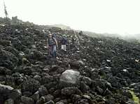 "Trail" across lava field
 Blue Lake Wash on west side of Mt.St.Helens
 Lunch below The Breach
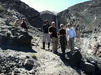 OSAT team at Loowit Falls
 Spirit Lake and Mt.Rainier in the distance
 Random spire on the 7500 ft traverse to Mt. Gilbert - Mt Adams in the background Photo credit: Andrew
Comments
Post a Comment