
-
 2437 Hits
-
 79.04% Score
-
 10 Votes
|
|
Route |
|---|---|
|
|
44.51141°N / 14.49732°E |
|
|
Download GPX » View Route on Map |
|
|
Hiking |
|
|
Spring, Summer, Fall, Winter |
|
|
Most of a day |
|
|
Easy hike |
|
|
Overview
This is a typical hike along the coast of one of the beautiful Adriatic islands. Not really a mountain hike, even if you'll need to overcome some good 300 m of elevation. But there's quite some distance (you can shorten or prolongate the tour by your needs) and extremely beautiful nature. Combine it with some swimming and sunbathing and you will spend a perfect outing!Getting There
Mali Lošinj, Kvarner, Croatia. See the parent page of Kvarner area how to get there!Route Details
It's an easy round hiking tour (T2), on which you will overcome some 24 kilometers and make some 310 m of elevation difference. Altogether count on some 7 hours, with stops, swimming etc., considerably more. You don't need any special gear, but good shoes are recommended (also sport shoes can do) and be sure to have enough to drink. In some coves you'll need suits for swimming, in most of others you are free to move around also naked.You start the hike in the center of Mali Lošinj.
Route Description

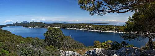
Vela Straža view
To see the route on map, activate the GPX file in the header!
From the center of Mali Lošinj we go along the bay coast towards the NW. You pass the road, deterring towards Čikat bay, but on the next crossroads it's worth deterring from the coast. You go some 100 m towards Čikat, but then deter right again and follow the marked path on the panoramic Vela Straža summit, 62 m.
![Losinj bay from Vela Straza]()
Lošinj bay from the summit of Vela Straža
From Vela Straža you descend again towards the NW (keeping left), so that you reach the coast of Lošinj bay again. Then simply continue around the peninsula tip and follow the coast southwards. You pass Zlatna uvala (cove), Srebrna uvala and then around Čikat peninsula enter the bay of Čikat.
![Cvanguski cove]()
Cvanguski coveFrom Čikat you keep following the coast. On the Madona peninsula there's a small church and a restaurant. Then you continue into Veli Žal (cove) - a big hotel there - and then continue past Borik, Porta Šešura to Cunguski cove. There the broad path, appropriate also for biking, turns into a narrow, marked path, suitable only for hiking.
The following coves are more solitary, on the beashes and on the path you will meet less people (depending on the season). Mala Draga, Vela Draga, Sunfarni and Krivica are all true marvels. From the shady Krivica you could continue towards the SE and start your return in any of the following coves. But the recommendation here is to ascend the main ridge by deterring from the coast in Krivica.
![Losinj path]()
Ascent pathA nice path goes up through dry walls, more or less in the northern direction. It is well marked. After gaining good 200 m of altitude you reach the asphalt road which goes from Mali Lošinj just by the top of the ridge. The church of Sv. Ivan is just some 150 m to the left. Nice place and great views around from there!
From Sv. Ivan you tahe the marked path down into Veli Lošinj town. It descends by the once more cultivated country directly into the picturesque port.
From Veli Lošinj you best follow the coast path (lungo mare) towards Mali Lošinj. You pass two north oriented coves and finally reach the first houses of Mali Lošinj. The center of the town is of course on the other side of the hill.
From the center of Mali Lošinj we go along the bay coast towards the NW. You pass the road, deterring towards Čikat bay, but on the next crossroads it's worth deterring from the coast. You go some 100 m towards Čikat, but then deter right again and follow the marked path on the panoramic Vela Straža summit, 62 m.
Lošinj bay from the summit of Vela Straža
From Vela Straža you descend again towards the NW (keeping left), so that you reach the coast of Lošinj bay again. Then simply continue around the peninsula tip and follow the coast southwards. You pass Zlatna uvala (cove), Srebrna uvala and then around Čikat peninsula enter the bay of Čikat.

Cvanguski cove
The following coves are more solitary, on the beashes and on the path you will meet less people (depending on the season). Mala Draga, Vela Draga, Sunfarni and Krivica are all true marvels. From the shady Krivica you could continue towards the SE and start your return in any of the following coves. But the recommendation here is to ascend the main ridge by deterring from the coast in Krivica.
 Uvala Krivica |  The scenery |  Afternoon in Krivica |

Ascent path
 Sv. Ivan panorama |  Veli Losinj |
From Sv. Ivan you tahe the marked path down into Veli Lošinj town. It descends by the once more cultivated country directly into the picturesque port.
From Veli Lošinj you best follow the coast path (lungo mare) towards Mali Lošinj. You pass two north oriented coves and finally reach the first houses of Mali Lošinj. The center of the town is of course on the other side of the hill.