
-
 16047 Hits
-
 93.1% Score
-
 41 Votes
|
|
Area/Range |
|---|---|
|
|
45.05560°N / 14.36390°E |
|
|
Hiking |
|
|
Spring, Summer, Fall, Winter |
|
|
2125 ft / 648 m |
|
|
Introduction
|
|
What's New On This Page?
The aim of this page is to give a geographical overview of Kvarner region, stress a few mountaineering highlights and give a few other general logistics info about the area. |
|
Kvarner And Its Islands
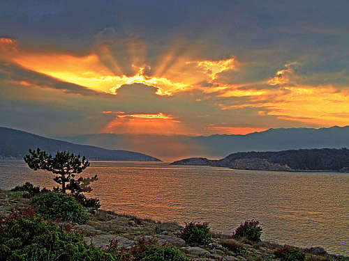
OverviewYou might think that good 600 m of altitude don't make a mountain. Yes, true, the Kvarner mountains are not high, nor can they impress with high rocky walls. What is most beautifu, there are nice views over the sea landscape, beautiful nature and archaic towns and villages of these islands. 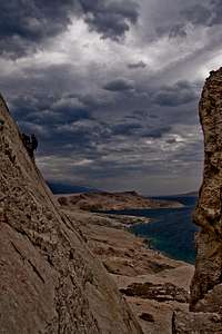 morceaux - climbing on Pag morceaux - climbing on PagKvarner is the largest bay of Adriatic sea, lying between Istra penninsula and the rest of Balcans. Both continental coasts are hilly. On Istra there's the Učka chain and on the eastern side there are Kapela and Velebit mountains. As this coast of Adriatic is slowly sinking (from the anciant Roman times the coast is more than a meter deeper), Kvarner islands are actually rests of mountain chains, thus having the same NW-SE direction as their continental counterparts. At the end of Kvarner bay a big Rijeka town stands and also the coast towards Crikvenica and Novi Vinodolski is much populated. South of Senj the coast under Velebit is much less inhabited. Also on islands there are some flourishing towns, but generally nature there is quite well preserved. The biggest Kvarner islands and their mountains are the following:
And there are some more islands, where hardly anyone goes, let alone mountaineering:
What To Do There? Branko - Goli otok Branko - Goli otokOn Kvarner islands people are coming to enjoy beautiful beaches and the sea. I can't help myself, but I allways have a feeling that locals are thinking that everyone who is not discovering this area in a natural way, meaning - with a boat, is completely crazy. Let alone to walk-up those bare limestone hills! But ok, some people have sailing in their genes, some have walking. And, there's not only summer time in Kvarner. The |
 Koromačno bay
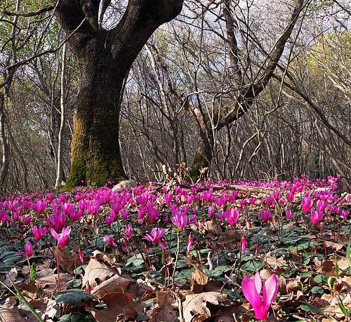
The most beautiful seasons for hiking are spring and autumn, even winter if you know when to avoid bura wind. All described hikes are quite easy. Even if terrain can be also steep and overgrown, there are no majod dangers on the paths. Due to rough rocks it's always good to have good trekking shoes and poles. Hikes can also be hot, and there's no water on those hills, so have in mind to take enough drinks with you. For climbing on Kvarner mountains some nice crags are arranged, for example: crags on Osoršćica, Pag climbing area, etc. And there's one more great option - cycling. With an ordinary bike or with a mountain bike you have almost endless opportunities for great tours. Some islands (like Cres) are quite strenuous, others are more easy. And what's most beautiful - you can take your bike on any ship or ferry and thus make great round tours, jumping from an island to another island.
Island Krk

Overview & Access
By their area, Krk and Cres are the biggest islands on Adriatic. The NW part of Krk is gently undulated with quite flat coastal areas. The SE part is however high and rugged, suitable for hiking. There are two mountain streaks, encircling the valley of Baška. The island is easily reachable. From the mainland south of Rijeka a mighty bridge is overarching the sea channel. On the other, W side, a ferry line is connecting Valbiska on Krk with Merag on Cres.
The N And W Coast
 Spring in Punat woods
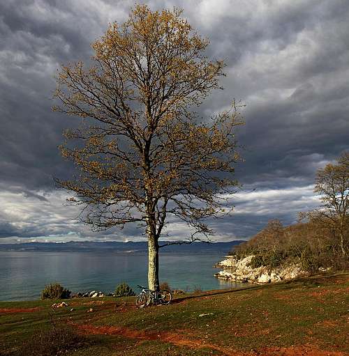 St. Martin bay
The N area has some industry, but also nice tourist destinations. The coast between Njivice and Malinska is nice for cycling. On the south, Malinska bay ends with Porat (small monastery there), beyond which nice forrests are criss-crossed with narrow roads, suitable for biking. On the coast there are nice bays, like St. Martin cove, where once a monastery stood. A few hundresd meters from the coast there is a panoramic Fumat hill, hosting a big cross. The N part of Krk is more populated (tourist areas of Soline and Klimno, Šilo peninsula). In the interior there is on almost 300 m the worth visiting old town of Dobrinj. Many marked hiking trails around can be combined with biking. On the SW coast there's the old Krk town and the nearby tourist landmark of Punat bay with a small Košljun island, hosting a monastery.
 St. Juraj bay
 Sršćica bay
Vrbnik
Vrbnik is one of the most picturesque old towns of Krk. For hikers it's a gate to the SE mountains. After a stroll through its narrow streets we can continue the hike along the coast towards SE, or we can try to reach the bay of Potovošće by car. From there a good marked path goes along the coast, passes Sv. Juraj bay and then over a saddle reaches the nice Sršćica bay. 1 h 30 min till there. From above Sršćica the path continues on Vinca pasture, then further up on Mali Hlam, and back down to Vrbnik.
Baška Valley
From the central Krk you reach Baška valley over the Malmašuta (Treskavac) saddle, 319 m. Hikes over the streaks on both sides of the valley can be combined by a bike descent, if you leave bikes on the saddle. The valley and the town of Baška are interesting in historical sense and worth a stroll.
Diviška Streak
 Mala luka from Corinthia
This plateau-like massif stretches from Vrbnik town towards the SE. The NE walls are almost impassable, from the other side many shepherts path reach up there. Exceptionally interesting is the pond below Diviška, divided by dry stone walls! From the summit of Diviška towards the NE the misterious Trget (also Triget) canyon descends. That's the narrowest gorge of Croatia. Up to 300 m high walls are on some places only 2 m apart. Passing it requires easy climbing of UIAA II degree. Towards the SE a much more kind Vrženica gorge descends. A nice hike connects Baška with the bays of Vela luka / Mala luka. From Bunculuka camp we best continue by the coast and then follow up in easy climbing the canyon of Vrženica, until reaching the direct upper path. On the crossroads we turn right, ascend the ridge and continue to Vela luka bay. Don't stop there, but go also up to the walls of ancient Corinthia fotrtess. From there we have a nice view also to Mala luka bay and its archeologic site. Then continue to Baška by the direct path (or take a boat).
Obzova Streak
 Baška from Bag summit
 Bracol coves
The highest streak of Krk rises on the SW side of Baška valley. Most of its hikes finisk on the panoramic summit of Obzova, which can be reached from Baška valley, from Malmašuta saddle, from the west or from the south. See the page of Obzova for all details! Nice is also the hike from Baška to Bracol, the southernmost end og Krk. We start in Zarok, S of Baška, from where a nice path brings us on the saddle below Bag, 185 m. Great views on Baška bay from there! On the other side the path descends across the slopes, passes above the ruins of St. Nikolaj church and finally descends to the coves of Bracol.
Island Cres
Overview & Access
Cres is a very diverse island - long with indented coast. Its highest and most interesing part for hiking is on the north. But there are also a few fine hikes on the west, around Lubenice village. There are two main approaches on Cres. One ferry comes from Brestova on Istria to Porozina, the other one from Valbiska on Krk island to Merag on the eastern coast. And you can also get to Cres town with a usual ship. With Lošinj, the island even more in the outer sea, Cres is connected by a good road.
Sis, Gorice And Beli Area
 On the summit of Sis
The road from Porozina (ferry) ascends across the western slopes of Cres to the altitude of 400 m and then descends a bit on the panoramic Križići saddle, 371 m. From there we have only a short 45 min ascent on the nearby Sis, 639 m, and some 20 more minutes by the main ridge on Gorice, 648 m, the highest summit of Kvarner islands. Nice hiking area is also the ancient town of Beli, NE of Gorice. We can either do one of thematic routes above the town, or even ascend the abandoned Niska village and continue by the main ridge on Gorice. If we had prepared a bike on Križići saddle, the return can be a fast one.
Helm And Lubenice Area
Lubenice is one of the most known villages on Adriatic islands. People have been living there for more than 4000 years. The village is situated high on a rocky ridge, 380 m above a wonderful white sands cove on the western coast. So, a typical hike there starts on top - then we descend to the bay or by the alternative path further to the south into another cove with a nice cave, called Modra špilja (Blue cave).
 Lubenice Lubenice |
 Bay below Lubenice Bay below Lubenice |
 Coast below Lubenice Coast below Lubenice |
We can also reach Lubenice from the south, from the tourist resort of Martinščica, or from Vidovići hamlet, 250 m above it. Nice marked path uses ancient shepherds paths, we pass a few abandoned ponds and finally reach the summit of Helm, 482 m, from where we continue to Lubenice. Nice views from Helm again - not only far around, but also on the nearby Vransko jezero (lake), which lies only 13 m above the sea level, but is 74 m deep.
 Vransko jezero Vransko jezero |
 A pond below Helm A pond below Helm |
 Helm from near Lubenice Helm from near Lubenice |
Finally, you can visit on Cres (on Punta Križa peninsula) also a dual cave, called Jami na sredi. There people lived from paleolithic till late antiquity.
Island Lošinj
Overview & Access
Lošinj is proud to claim mountaineering history since 1887 and it is connected with Osoršćica, the highest summit on the island. Some nice hikes can be done along the coast also on the southern part of island. Lošinj was in the past connected to Cres island, but Ancient Romans cut a channel in Osor town, making it an island. With Cres it is connected by a good road and in Mali Lošinj you can reach with a ship.
Osorščica And The Rest
 Mali Lošinj with Osoršćica
The 588 m high Osoršćica is an impressive mountain in the middle of Adriatic sea, offering a lot of outdoor activities. See more information on its SP page!
On the south of Lošinj, there is a nice hiking area around Veli Lošinj town. We can combine it with biking, for example, we can ascend to Sv. Ivan church, some 250 m, on the main ridge, and then descend to the southern coast and continue along it.
 Biking or hiking? Biking or hiking? |
 Southern Lošinj coast Southern Lošinj coast |
 Sunset at Sv. Ivan Sunset at Sv. Ivan |
 Lošinj path Lošinj path |
Island Rab
Overview & Access
Rab is also a very diverse and nice island, but rarely anyone comes there to do a mountain hike. Its highest summit is the panoramic Kamenjak, 410 m, but there a narrow road reaches. So people do there mostly short walks around. A very nice hiking area is the Lopar peninsula. There are no mountains, but the coast hike is wonderful and can take you a whole day. Finally, the Kalifront peninsula is worth mentioning, mostly for biking tours. Rab can be reached by car, taking a ferry in Jablanac on the mainland.
Kamenjak And Lopar
You can reach Kamenjak and its highest point Straža by a narrow road, or from the neighbourhood of Rab town by a marked path. The summit is a funny stone desert, but with a nice view, especially towards the east (on Velebit mountain) and also down to the flourishing town of Rab.
 Rab town from Kamenjak Rab town from Kamenjak |
 On Kamenjak plateau On Kamenjak plateau |
 Kamenjak stone desert Kamenjak stone desert |
Lopar peninsula is aspecial place, very interesting in a geological, historical and touristical sense. It is best to leave car somewhere between Lopar town and Ciganka bay and then go along the coast in a clockwise direction. The first bay, called Ciganka, is a true pearl and then we slowly continue, partially walking by a shore or even simply crossing shallow bays. You may not visit just all peninsula, use common sense. The walk will take you more than half a day, take enough drink with you.
 Lopar monsters Lopar monsters |
 Lopar monsters Lopar monsters |
 Kamenjak from Lopar Kamenjak from Lopar |
Island Pag
Overview & Access
 Velebit - Pag island
Also Pag island is having many attractive attributes, but less in a mountaineering or hiking sense. Its highest summit is Sv. Vid, 349 m, which is well worth visiting. But it's a short hike only. In recent years the unusual climbing area of Stogaj is getting quite popular. Climbers get attracted by its moonlike appearance and clear sea nearby, On Pag we can reach by a car from the south-east, from near Nin town, using a bridge. But for most of Europeans it's a bit around, so many take a ferry, which connects Prizna on the mainland and the NE coast of Pag.
Sv. Vid And The Rest
The highest summit of Pag is quite a desert landscape, but views around are nice. Routes from three directions ascend on top, leaving bikes on trailheads they can be also combined. See more information on Sveti Vid SP page!


Stogaj climbing area is situated close to Metajna, on the NE peninsula of Pag. See more information about its routes on its the SP page!
 marlenka - climbing on Stogaj marlenka - climbing on Stogaj |
 marlenka - Moon landscape Stogaj marlenka - Moon landscape Stogaj |
 julesblaidd - Stogaj tower julesblaidd - Stogaj tower |
 julesblaidd - wall in Stogaj julesblaidd - wall in Stogaj |
Getting There
Islands Krk and Pag can be reached from the mainland over two big bridges. In addition, the long Pag island can be reached also by a ferry boat from Prizna village. Island Rab can be reached by a ferry boat from Jablanac. In summer (high season) there's also a ferry boat connection Baška (Krk) - Lopar (Rab). Cres can be reached by a ferry boat from Istra (from Brestova) and from Krk (from Valbiska). Along the whole Cres island a good road runs and over a bridge at Osor reaches also Losinj island. On Losinj the road goes till Veli Lošinj. Ferry boats usually go frequently enough. Outside of the main season this can still be every hour, in many cases also every half an hour. You should have in mind that last ferries go usually somewhere around 8 p.m. The biggest ferry boat operator on Kvarner area is Jadrolinija. Using this link choose one of the three uppermost areas and explore itineraries. The ferry boat Jablanac-Rab is served by Rapska plovidba. Here the link to itinerary.
Red Tape
On these mountains there are no restrictions. Camping is generally not allowed outside established camping places, but if you come in the evening and sleep in a tent over the night, nobody will probably bother you. Due to low altitudes, almost all tours can be undertaken in one day.
When To Climb
All the year. In any case do choose a clear day, which will offer you good visibility. Nothing can be more valuable! Usually the best visibility is, when bura wind (north wind) blows. Also, you can choose to climb up early in the morning or late in the afternoon, when it's not so hot. By far the best seasons are spring and autumn.
Camping
All bigger Kvarner islands are turistically well developed. So in neighbouring destinations you will easilly find decent camps. And there's even one official mountain hut! On the north ridge of Osoršćica, there's St. Gaudent hut, standing on the altitude of 274 m. Make sure in Osor town if the hut is opened.