Being a tourist
The mountains of the Cordillera Vilcanota had brought me to Cuzco in the first place, but Machu Picchu is so close, I just had to have a look for myself. And I wasn't disappointed!
![Local flora at Machu Picchu]() Local flora
Local flora
I like hiking, but the famous Inca trail was no option. First of all, you have to book a place far in advance and I prefer to be flexible. Furthermore, you can't do it independently. Mind you, I do understand these precautions. Without it, the trail would be swamped by people and littered everywhere I'm sure. And, finally, it seems to me that the four days of the organised tours make for rather short daily walks.
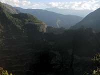
![Machu Picchu from Putucusi]() Machu Picchu from Putucusi
Machu Picchu from Putucusi
So, how to get there? Well, by train to Aguas Calientes, like all the other tourists of course!
Machu Picchu lies at around 2500m on a broad ridge between the small steep hill of Huayna Picchu and the much larger Cerro Machu Picchu. 500m lower, Rio Urubamba flows around the site, and very steep hills line the valley. The train goes as far as Aguas Calientes, aka Machu Picchu village. Right next to the village, even before Machu Picchu itself, lies Putucusi, one of these very steep hills, offering a great view to the ruins - if only I had been there early in the morning instead of the afternoon, then the light would have been great for taking pictures. However, that would have meant staying another day.
![The Cordillera Urubamba from Cerro Machu Picchu]() The Cordillera Urubamba from Cerro Machu Picchu
The Cordillera Urubamba from Cerro Machu Picchu
In 2011, the rules were that up to 400 people were allowed to climb Huayna Picchu; A first group of up to 200 that were waiting in line at 7 am were allowed in, then a second group of 200 at 10 am. I reckoned that, at 7, the line would probably not have 200 people, so I set my alarm early. However, when I woke up just after 4 am, I was too sleepy, so I turned over and dozed off a couple more hours.
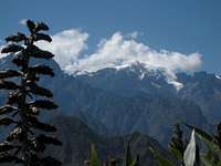
![Nevado Veronica]() Nevado Veronica
Nevado Veronica
It was shortly after 7 when I left Aguas Calientes. Shuttle buses ferry loads of tourists up the 8km road to the entrance to Machu Picchu, but I had decided to walk instead. Partly that's along the road, but there is quite a nice trail for most of the way. The information I could find on how long that trail would take was rather mixed: anywhere from 40 minutes to 1.5 hours is what I read. It turned out to be close to the latter. Makes sense, considering the elevation gain of about 500m. I met only a few fellow hikers on the trail, but I think it's an excellent way to get up there.
So, I was at the ruins around half past eight. I didn't fancy waiting in line for Huayna Picchu, so I headed the other way and took my time hiking up to the summit of Cerro Huayna Picchu, another 5 or 600m. Now, I certainly wasn't the only one, but most visitors seemed to be discouraged by the exercise and were content to wander around on the site itself, or go on a guided tour. Fine by me, that made the hike much more pleasant. Lower on the trail were lots of flowers. Sometimes I had a clear view of Machu Picchu, with its unique location. On the summit, the snowcapped mountains of Salcantay, Pumassillo and Veronica can be seen in the distance.
![Hugging the wall]() Hugging the wall on the trail to the Inca drawbridge
Hugging the wall on the trail to the Inca drawbridge![Closer view of the Inca drawbridge]() Closer view of the Inca drawbridge
Closer view of the Inca drawbridge
After that, I had a look at the Inca drawbridge. It's basically a gap in a trail on a vertical mountain face. With some planks, it's easy to cross, without it, almost impossible, which makes the access to Machu Picchu easy to defend.
![Ancient stone work at Machu Picchu]() Ancient Stone work
Ancient Stone work
To top it off, I wandered around Machu Picchu for a couple of hours, all the time feeling amazed. It's not so much the ancient stone work, or the ruins themselves - it's the setting that makes it so special.
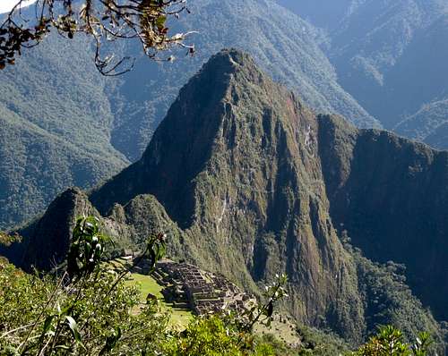
![Machu Picchu]() Machu Picchu from the slopes of Cerro Machu Picchu
Machu Picchu from the slopes of Cerro Machu Picchu
Comments
No comments posted yet.